Harrington, Maine facts for kids
Quick facts for kids
Harrington, Maine
|
|
|---|---|

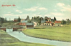
View of Harrington c. 1908
|
|
| Country | United States |
| State | Maine |
| County | Washington |
| Incorporated | 1797 |
| Area | |
| • Total | 50.31 sq mi (130.30 km2) |
| • Land | 21.11 sq mi (54.67 km2) |
| • Water | 29.20 sq mi (75.63 km2) |
| Elevation | 13 ft (4 m) |
| Population
(2020)
|
|
| • Total | 962 |
| • Density | 46/sq mi (17.6/km2) |
| Time zone | UTC-5 (Eastern (EST)) |
| • Summer (DST) | UTC-4 (EDT) |
| ZIP code |
04643
|
| Area code(s) | 207 |
| FIPS code | 23-31530 |
| GNIS feature ID | 0582512 |
Harrington is a town in Washington County, Maine, United States. In 2020, the population was 962 people. Harrington is known as an old village with a history of seafaring and shipbuilding.
Contents
History of Harrington
Originally, this area was called Plantation Number 5. It was one of six townships given out in 1762. This grant came from the Massachusetts General Court, which was like the government at that time.
The first settlers arrived around 1765. By June 17, 1797, 177 people lived there. On that date, it officially became a town and was named Harrington.
Early Industries and Trade
Farmers in Harrington grew crops like wheat and potatoes. The town also became important for its lumber trade. By 1859, Harrington had several mills. These included two sawmills, three mills for making shingles, and two mills for lath (thin strips of wood).
Other businesses in town included a gristmill (for grinding grain) and two brickyards. There was also a tannery, which processed animal hides into leather. Shipbuilding was a major industry, with eighteen different shipbuilders working in the town.
By 1886, Harrington's industries also included a sailmaker. There was also a company that made boots and shoes. Today, the Gallison Memorial Library still serves the community in Harrington.
Geography of Harrington
According to the United States Census Bureau, Harrington covers a total area of about 50.31 square miles (130.30 square kilometers). Of this, about 21.11 square miles (54.67 square kilometers) is land. The remaining 29.20 square miles (75.63 square kilometers) is water.
The town is located at the top of Narraguagus Bay. It is also next to Harrington Bay and Pleasant Bay. These bays are part of the Gulf of Maine. Several waterways flow through Harrington, including Curtis Creek, the Mill River, and the Harrington River.
Harrington is connected by major roads. U.S. Route 1 and U.S. Route 1A both pass through the town. Harrington shares its borders with several other towns. These include Milbridge to the west and Cherryfield to the northwest. To the north is Columbia, and to the east is Addison.
Population Information
| Historical population | |||
|---|---|---|---|
| Census | Pop. | %± | |
| 1800 | 298 | — | |
| 1810 | 469 | 57.4% | |
| 1820 | 732 | 56.1% | |
| 1830 | 1,118 | 52.7% | |
| 1840 | 1,542 | 37.9% | |
| 1850 | 963 | −37.5% | |
| 1860 | 1,130 | 17.3% | |
| 1870 | 1,142 | 1.1% | |
| 1880 | 1,290 | 13.0% | |
| 1890 | 1,150 | −10.9% | |
| 1900 | 1,165 | 1.3% | |
| 1910 | 1,020 | −12.4% | |
| 1920 | 1,024 | 0.4% | |
| 1930 | 865 | −15.5% | |
| 1940 | 918 | 6.1% | |
| 1950 | 853 | −7.1% | |
| 1960 | 717 | −15.9% | |
| 1970 | 553 | −22.9% | |
| 1980 | 859 | 55.3% | |
| 1990 | 893 | 4.0% | |
| 2000 | 882 | −1.2% | |
| 2010 | 1,004 | 13.8% | |
| 2020 | 962 | −4.2% | |
| U.S. Decennial Census | |||
2010 Census Details
In 2010, the census showed that 1,004 people lived in Harrington. There were 419 households and 290 families. The town had about 47.6 people per square mile (18.4 per square kilometer).
Most residents were White (97.5%). A small number of people identified as African American, Native American, or Asian. Some people also identified as being of Hispanic or Latino background.
About 29.1% of households had children under 18 living with them. Most households (54.2%) were married couples living together. The average household had 2.38 people, and the average family had 2.76 people.
The median age in Harrington was 44.9 years. About 21.1% of residents were under 18 years old. About 18.7% were 65 years or older. The population was almost evenly split between males (49.8%) and females (50.2%).
Education in Harrington
- The town is home to Narraguagus High School.
Notable People from Harrington
- Irv Ray – An MLB (Major League Baseball) player for teams like the Boston Beaneaters and Baltimore Orioles.
- Tiffany Strout – A member of the Maine House of Representatives, which is part of the state's government.
See also
 In Spanish: Harrington (Maine) para niños
 | George Robert Carruthers |
 | Patricia Bath |
 | Jan Ernst Matzeliger |
 | Alexander Miles |


