Harrison County, Iowa facts for kids
Quick facts for kids
Harrison County
|
|
|---|---|

|
|

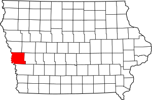
Location within the U.S. state of Iowa
|
|
 Iowa's location within the U.S. |
|
| Country | |
| State | |
| Founded | 1851 |
| Named for | William Henry Harrison |
| Seat | Logan |
| Largest city | Missouri Valley |
| Area | |
| • Total | 702 sq mi (1,820 km2) |
| • Land | 697 sq mi (1,810 km2) |
| • Water | 4.8 sq mi (12 km2) 0.7% |
| Population
(2020)
|
|
| • Total | 14,582 |
| • Estimate
(2023)
|
14,670 |
| • Density | 20.772/sq mi (8.020/km2) |
| Time zone | UTC−6 (Central) |
| • Summer (DST) | UTC−5 (CDT) |
| Congressional district | 4th |
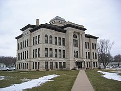
Harrison County is a county in the state of Iowa, USA. It was created in 1851. The county is named after William Henry Harrison, who was the ninth US President.
In 2020, about 14,582 people lived here. The main town, or county seat, is Logan. Harrison County is part of the larger Omaha-Council Bluffs Metropolitan Area. This area includes parts of Nebraska and Iowa.
Contents
Exploring Harrison County's Land
Harrison County covers a total area of about 702 square miles. Most of this area, around 697 square miles, is land. The remaining 4.8 square miles, or 0.7%, is water.
Main Roads in the County
Several important roads run through Harrison County. These highways help people travel easily across the county and to other places.
 Interstate 29
 U.S. Highway 30
 Iowa Highway 37
 Iowa Highway 44
 Iowa Highway 127
 Iowa Highway 183
 Iowa Highway 191
Neighboring Counties
Harrison County shares its borders with several other counties.
- Monona County (to the north)
- Crawford County (to the northeast)
- Shelby County (to the east)
- Pottawattamie County (to the south)
- Washington County, Nebraska (to the southwest)
- Burt County, Nebraska (to the northwest)
Protected Natural Areas
Part of the DeSoto National Wildlife Refuge is located in Harrison County. This refuge is a special place that protects wildlife and their habitats.
Who Lives in Harrison County?
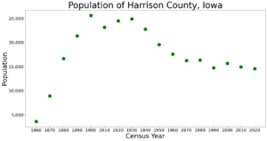
The number of people living in Harrison County has changed over the years.
| Historical population | |||
|---|---|---|---|
| Census | Pop. | %± | |
| 1860 | 3,621 | — | |
| 1870 | 8,931 | 146.6% | |
| 1880 | 16,649 | 86.4% | |
| 1890 | 21,356 | 28.3% | |
| 1900 | 25,597 | 19.9% | |
| 1910 | 23,162 | −9.5% | |
| 1920 | 24,488 | 5.7% | |
| 1930 | 24,897 | 1.7% | |
| 1940 | 22,767 | −8.6% | |
| 1950 | 19,560 | −14.1% | |
| 1960 | 17,600 | −10.0% | |
| 1970 | 16,240 | −7.7% | |
| 1980 | 16,348 | 0.7% | |
| 1990 | 14,730 | −9.9% | |
| 2000 | 15,666 | 6.4% | |
| 2010 | 14,928 | −4.7% | |
| 2020 | 14,582 | −2.3% | |
| 2023 (est.) | 14,670 | −1.7% | |
| U.S. Decennial Census 1790-1960 1900-1990 1990-2000 2010-2018 |
|||
Population in 2020
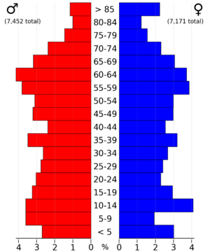
The 2020 census counted 14,582 people in Harrison County. This means there were about 20 people living per square mile. Most people, about 96.78%, said they belonged to one race. About 93.46% were non-Hispanic White. Other groups included Black (0.19%), Hispanic (2.01%), Native American (0.20%), and Asian (0.34%). A small number were Native Hawaiian or Pacific Islander (0.02%). About 3.78% were of another race or more than one race. There were 6,665 homes in the county, and 5,951 of them were lived in.
Towns and Communities
Harrison County has several cities and smaller communities.
Cities in Harrison County
Smaller Communities and Areas
Besides the cities, there are also smaller communities and areas called townships.
Townships in Harrison County
- Allen
- Boyer
- Calhoun
- Cass
- Cincinnati
- Clay
- Douglas
- Harrison
- Jackson
- Jefferson
- La Grange
- Lincoln
- Little Sioux
- Magnolia
- Morgan
- Raglan
- St. Johns
- Taylor
- Union
- Washington
Other Small Towns
These are smaller places that are not officially cities.
- California Junction
- River Sioux
- Orson
- Yorkshire
- Beebeetown
How Big Are the Towns?
Here's a list of the cities and towns in Harrison County, from largest to smallest, based on the 2020 census. † The county seat, which is the main town.
| Rank | City/Town/etc. | Type | Population (2020 Census) |
|---|---|---|---|
| 1 | Missouri Valley | City | 2,678 |
| 2 | Woodbine | City | 1,625 |
| 3 | † Logan | City | 1,397 |
| 4 | Dunlap (partially in Crawford County) | City | 1,038 (1,038 total) |
| 5 | Mondamin | City | 339 |
| 6 | Persia | City | 297 |
| 7 | Modale | City | 273 |
| 8 | Pisgah | City | 249 |
| 9 | Magnolia | City | 190 |
| 10 | Little Sioux | City | 166 |
| 11 | California Junction | CDP | 74 |
| 12 | River Sioux | CDP | 42 |
See also
 In Spanish: Condado de Harrison (Iowa) para niños
 | James B. Knighten |
 | Azellia White |
 | Willa Brown |


