
Henderson, New York facts for kids
Quick facts for kids
Henderson, New York
|
|
|---|---|

Henderson, New York
Location in New York

Henderson, New York
Location in the United States
|
|
| Country | United States |
| State | New York |
| County | Jefferson |
| Government | |
| • Type | Town Council |
| Area | |
| • Total | 52.93 sq mi (137.10 km2) |
| • Land | 41.18 sq mi (106.65 km2) |
| • Water | 11.76 sq mi (30.45 km2) |
| Elevation | 410 ft (125 m) |
| Population
(2010)
|
|
| • Total | 1,360 |
| • Estimate
(2016)
|
1,352 |
| • Density | 32.83/sq mi (12.68/km2) |
| Time zone | UTC-5 (Eastern (EST)) |
| • Summer (DST) | UTC-4 (EDT) |
| ZIP code |
13650 (Henderson), 13651 (Henderson Harbor)
|
| Area code(s) | 315 |
| FIPS code | 36-045-34055 |
| GNIS feature ID | 0979062 |
Henderson is a small town located in Jefferson County, New York, United States. In 2010, about 1,360 people lived here. The town gets its name from William Henderson, who was the first European-American person to own land in this area.
Henderson is in the western part of Jefferson County. It is located southwest of the city of Watertown. The Great Lakes Seaway Trail, a scenic road, passes through the town. This trail follows New York State Route 3 and has a special monument dedicated to its founder, William E. Tyson.
Contents
History of Henderson
Early Native American Life
For a long time, the Onondaga people lived in this area. They were part of the Iroquois Confederacy, a powerful group of Native American tribes. By the 1400s, this confederacy controlled much of upstate and western New York.
During the American Revolutionary War, many Iroquois tribes sided with the British. After Britain lost the war, the United States made the Iroquois give up most of their land in New York. Many tribes then moved to Canada, where the British offered them new lands in what is now Ontario.
European Settlement and Growth
After the war, New York State wanted to encourage people to move to and farm its western lands. So, it sold millions of acres of the former Iroquois lands at very low prices. Some land was even given to soldiers who fought in the war. Wealthy people from New York City also bought large areas of land to sell later.
In 1801, a surveyor named Benjamin Wright mapped out the town into different sections. However, people didn't start settling here until 1802. Most of these early settlers came from New England, where there wasn't much farmland left.
The town of Henderson was officially created in 1806. It was formed from a part of the nearby town of Ellisburg.
Historic Buildings in Henderson
Henderson is home to some historic buildings. The Cyrus Bates House was added to the National Register of Historic Places in 2004. The Norton–Burnham House, which is the birthplace of famous architect Daniel Burnham, was added in 2016.
Famous People from Henderson
Henderson has been home to several notable individuals who achieved great things.
- Joseph Hawkins (1781–1832): He was a United States Representative, meaning he served in the U.S. Congress.
- Charles G. Finney (1792–1875): A well-known Presbyterian minister and speaker. He also worked to end slavery and supported education for both boys and girls. He was the second president of Oberlin College.
- Hiram Barney (1811–1895): A lawyer and a strong supporter of the movement to end slavery.
- Horatio N. Davis (1812–1907): He was a member of the Wisconsin State Senate, helping to make laws for Wisconsin.
- Cyrus H. Wheelock (1813–1894): An early Mormon missionary and someone who wrote hymns (religious songs).
- Mark Hopkins (1813–1878): A very important person in the railroad industry. He was one of the "Big Four" who helped build the Central Pacific Railroad.
- Buel Hutchinson (1826–1903): A politician and lawyer.
- John Watson Foster (1836–1913): He served as the U.S. Secretary of State, a top government position. He was also an ambassador and military officer. He spent his summers in Henderson Harbor.
- Cushman Kellogg Davis (1838–1900): The son of Horatio N. Davis, he became a governor and U.S. senator for Minnesota.
- George Wilbur Peck (1840–1916): He was the governor of Wisconsin and the mayor of Milwaukee. He was also a newspaper publisher and wrote the popular "Peck's Bad Boy" stories.
- Daniel Burnham (1846–1912): A very famous architect and city planner. He designed many well-known buildings, including the Flatiron Building in New York City and Union Station in Washington D.C. He also planned parts of many cities.
- John Foster Dulles (1888–1959): A United States Senator and U.S. Secretary of State. He also spent his summers in Henderson Harbor.
- Allen Dulles (1893–1969): He was the first civilian director of the Central Intelligence Agency (CIA). He also summered in Henderson Harbor.
- Eleanor Lansing Dulles (1895–1996): An author, professor, and government envoy.
- Craig Conroy: A professional ice hockey player who played in two Olympic Games. He is currently an assistant general manager for the Calgary Flames in the National Hockey League.
Geography and Natural Features
Henderson covers a total area of about 137.1 square kilometers (52.9 square miles). Most of this area, about 106.7 square kilometers (41.2 square miles), is land. The rest, about 30.4 square kilometers (11.8 square miles), is water. The western edge of the town is along the beautiful Lake Ontario.
Roads and Highways
- New York State Route 3: This is a main highway that runs north and south through the town.
- New York State Route 178: This highway runs east and west and crosses NY-3 at a place called Aspinwall Corners.
Communities and Places to Visit
Henderson has several small communities and interesting spots:
- Alexander Corners: A small area southwest of Henderson village on NY-3.
- Aspinwall Corners: Located west of Henderson village on NY-3.
- Babbitt Corners: Found in the northeastern part of town on County Road 71.
- Bishop Street: A location west of Butterville.
- Butterville: A small village near the eastern town line on County Road 75.
- Clark Point: A small village right on the shore of Lake Ontario, located on Stony Point.
- Henderson: This is the main village. It used to be an officially recognized village but changed its status in 1992. Now, it's a census-designated place.
- Henderson Harbor: A village on the shore of Henderson Bay. It was once called "Naples."
- Hungerford Corners: A small area west of Henderson village.
- Roberts Corners: A village in the southeastern part of town on NY-178 at County Road 75.
- Scotts Corners: A location near the southern town line on NY-178 at County Road 152.
Lakes, Bays, and Islands
- Association Island: An island located near the northern tip of Stony Point.
- Clark Point: A narrow piece of land that extends into the water, west of Sawyers Bay.
- Crystal Lake: A lake in the southeastern part of town, also known as "Sixtown Pond."
- Gravely Bay: A bay at the western end of Stoney Point.
- Henderson Bay: A part of Lake Ontario in the northwestern area of town, partly surrounded by Stony Point.
- Henderson Pond: A lake southwest of Henderson village.
- Hoveys Island: Located at the northern tip of Stony Point.
- Rays Bay: A bay at the southwestern tip of Stony Point.
- Sawyers Bay: A bay where Stony Point connects to the mainland.
- Sawyer Point: A piece of land east of Sawyer Bay.
- Six Town Point: A location near the northern tip of Stony Point.
- Stony Creek: A stream that flows west through the northern part of Henderson.
- Stony Point: A peninsula that reaches into Lake Ontario in the western part of the town.
State Parks
- Robert G. Wehle State Park: A state park located on Stony Point.
- Westcott Beach State Park: A state park near the northern town line and Lake Ontario.
Population and People
| Historical population | |||
|---|---|---|---|
| Census | Pop. | %± | |
| 1820 | 1,919 | — | |
| 1830 | 2,428 | 26.5% | |
| 1840 | 2,480 | 2.1% | |
| 1850 | 2,239 | −9.7% | |
| 1860 | 2,419 | 8.0% | |
| 1870 | 1,926 | −20.4% | |
| 1880 | 1,842 | −4.4% | |
| 1890 | 1,688 | −8.4% | |
| 1900 | 1,615 | −4.3% | |
| 1910 | 1,485 | −8.0% | |
| 1920 | 1,229 | −17.2% | |
| 1930 | 1,165 | −5.2% | |
| 1940 | 1,163 | −0.2% | |
| 1950 | 1,171 | 0.7% | |
| 1960 | 1,207 | 3.1% | |
| 1970 | 1,364 | 13.0% | |
| 1980 | 1,330 | −2.5% | |
| 1990 | 1,268 | −4.7% | |
| 2000 | 1,377 | 8.6% | |
| 2010 | 1,360 | −1.2% | |
| 2016 (est.) | 1,352 | −0.6% | |
| U.S. Decennial Census | |||
In 2000, there were 1,377 people living in Henderson. These people lived in 577 households, and 406 of these were families. The population density was about 33.3 people per square mile. There were also 1,557 housing units, like houses or apartments.
Most of the people in Henderson (98.69%) were White. A small number were Native American (0.22%) or from other races. About 0.65% of the population was Hispanic or Latino.
About 23.2% of households had children under 18 living with them. Most households (59.3%) were married couples living together. About 23.9% of all households were made up of single individuals.
The average age of people in Henderson was 44 years old. About 20.3% of the population was under 18, and 19.0% were 65 or older.
The average income for a household in the town was $37,019. For families, the average income was $45,357. About 11.1% of the total population lived below the poverty line.
Images for kids
-
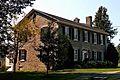
Norton–Burnham House, the birthplace of Daniel Burnham in Henderson

See also
 In Spanish: Henderson (Nueva York) para niños
