History of Brevard County, Florida facts for kids
The History of Brevard County tells the story of people living in this area of Florida for thousands of years, from ancient times to today. Brevard County is located along the Atlantic Ocean coast. Its borders have changed a lot since it was first created. The county is named after Judge Theodore W. Brevard, an early settler and state leader. It was first called St. Lucie County until 1855. The main office for the county has been in Titusville since 1894, but much of the county's work is now done in Viera.
Contents
Ancient Times in Brevard County
First People Arrive
The very first people, called Paleo-Indians, came to the Brevard County area about 12,000 to 10,000 years ago. These people were semi-nomadic, meaning they moved around in small groups. At that time, the Earth was getting warmer after a big ice age. The weather here was different from today, more like Great Britain. Brevard County probably wasn't on the coast back then. Florida's coast was about 100 miles (160 km) wider, and the Indian River was just a low, dry area.
After a few thousand years, by about 3000 B.C., Florida looked more like it does now. The ocean had risen enough to fill the Indian River with salt water.
The Archaic People
Around this time, a new group of settlers appeared. They are known as "the archaic people." These people mainly fished for food. This was different from the Paleoindians, who mostly hunted and gathered. It is believed that these Archaic people were the ancestors of the Native Americans who later met the Europeans.
From Spanish Explorers to Statehood
Native Tribes and Early European Contact
The Ais and Jaega tribes lived in this area when Ponce De Leon likely landed near Melbourne Beach in 1513. There were about 10,000 native people living here then.
In 1565, French sailors from Fort Caroline were shipwrecked near Cape Canaveral. They built a fort from their ship's wood.
Pedro Menéndez de Avilés wrote about the Ais Indians in 1570. He was shipwrecked off Cape Canaveral. He faced hostile natives but managed to escape back to St. Augustine.
In 1605, Alvero Mexia was sent from St. Augustine to the Indian River area. His mission was to make peace with the Ais Indian Nation. He helped create a "Period of Friendship" with the Ais chiefs. He also made a color map of the area.
Challenges for Early Settlers
Many mosquitoes and the danger of Indian attacks kept white settlers away. The Spanish soon left the area. But they left behind European diseases, which were deadly. By 1763, the Spanish took the last 80 native people to Cuba.
Within 200 years, almost all the native people in Florida had died out. Creek Indians from the north moved into the area. These Indians became known as the Seminole. They were in Brevard County sometimes, but usually didn't stay permanently.
Throughout the 1700s, Spain, Great Britain, and France fought for control of Florida. They were more interested in its location than in building settlements. Back then, Florida was seen as a dangerous place. It had venomous snakes, alligators, and panthers. People could also die from malaria or Indian attacks. After being ruled by Spain, France, Britain, and then Spain again, Florida finally became a United States territory.
In 1837, Fort Ann was built on Merritt Island, on the eastern shore of the Indian River. During the building of the Hernández–Capron Trail, General Joseph Hernandez and his soldiers camped near what is now Mims. These early settlements did not last long.
Brevard County: From Statehood to the 1900s
Florida Becomes a State
In 1845, Florida became the 27th state in the United States.
During the 1800s, Florida often changed county names and borders. St. Lucie County was separated from Mosquito County in 1844. St. Lucie County was renamed Brevard County in 1855. It was named after Theodore Washington Brevard, who was Florida's money manager from 1854 to 1860. This "Brevard County" was very different from today's Brevard County. Most of today's Brevard County north of Melbourne was part of Volusia or Orange counties.
The original county seat was at Susannah, which is now Fort Pierce. Later, the southern part of Brevard split off to form a new St. Lucie County in 1905. Over time, Brevard County's borders moved north and east. Parts of Volusia and Orange Counties were added to Brevard, including Titusville, which became the county seat.
Early Settlements and Growth
The first lasting settlement in today's Brevard was near Cape Canaveral in 1848. After a lighthouse was built, a few families moved in. A small, stable community began there. As the danger from Seminole Indian attacks lessened, more people moved to the Indian River area. In the 1850s, a small community grew at Sand Point, which later became Titusville. The American Civil War did not affect Brevard County much, except perhaps slowing down new settlers.
In 1864, the county seat moved to Bassville, which is now in Osceola County. In 1874, it moved to Eau Gallie. Then in 1875, the seat moved to Lake View.
In 1870, the Barber–Mizell feud happened. This was a conflict due to disagreements over the Reconstruction period after the Civil War. It also involved a border dispute with Orange County and cattle taxes.
By the 1880s, cities along the Indian River included Melbourne, Eau Gallie, Titusville, Rockledge, and Cocoa. These cities used water travel more than roads. In 1877, steamboat travel became common.
The area really started to grow when Henry Flagler's Florida East Coast Railroad arrived. The railroad reached Titusville in 1886 and Melbourne in 1894. With the railroad came more settlers and the first tourists.
Brevard County: The 20th Century to Today
The Automobile Age and Space Race
When cars became popular, Brevard County grew even more. Resorts and hotels appeared everywhere. Roads were built, connecting Brevard County to the rest of Florida and the country.
A big land boom started in the 1920s after World War I. Many people moved to Florida, and land prices went very high. But then the Great Depression caused growth to stop for a while. Before World War II, the main jobs in Brevard were commercial fishing, growing citrus, and tourism.
In 1940, the Naval Air Station Banana River (now Patrick Air Force Base) was built. This started a new time for Brevard County. The government paid for building what is now Florida State Road A1A along the ocean. This road gave cars access to the air station.
In the late 1950s, the Long Range Proving Ground opened. This later became the Kennedy Space Center. This completely changed the county. Brevard had been a quiet, rural area. Suddenly, it became the place where rockets launched into space! The economy changed from farming and fishing to high-tech engineering and computers.
In the 1960s, new residents found local shops not very exciting. They drove to Orlando to shop. People worried that new malls would hurt the downtown areas of Cocoa, Melbourne, and Titusville. This did happen, but these downtown areas became lively again in the 2000s.
Controlling Mosquitoes and Building Bridges
Brevard County used to have a lot of mosquitoes, especially in wet areas. This made many parts of the county hard to live in. In 1950, mosquitoes were controlled using DDT, an insecticide. This made much of the county livable, and many people moved in. When DDT became illegal, other safer ways to control mosquitoes were used.
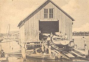
Ferries used to cross the Indian River. In the early 1900s, wooden bridges replaced them. These bridges had gates for boats to pass. In the 1960s, these were replaced by tall steel bridges, allowing boats to pass underneath easily.
In 1982, the Windover Archaeological Site was discovered. This site is very important for understanding ancient life in Florida.
County Seat Changes and Growth Challenges
Brevard County is very long but not wide. People in the southern, more populated part of the county complained about being far from the county seat in Titusville. A trip to Titusville from Palm Bay, the most populated city, was about 50 miles (80 km). There was talk of the southern part of the county breaking away to form its own county. So, the county decided to build a new administration complex in Viera. Viera is near the center of the county. This complex started in 1989. This led to a counter-threat from the Titusville area to form a new county called Playalinda County. The county made some agreements with the northern part of the county. They agreed not to officially move the county seat. However, Viera is now the main place where Brevard County business is done.
In the summer of 1998, some of the worst brush fires ever happened. About 70,000 acres (283 km²) were burned. Before controlled burns were used, county forests and pastures would burn for months during the dry season. From the 1940s to the 1970s, the state took control of burning to prevent uncontrolled fires. In 2006, the state burned a record 72,065 acres (292 km²) in the county.
In 2004, Brevard County was ranked 13th out of 318 large counties in the US for job growth. The county moved up in rankings for "Best Performing" metropolitan areas. This was mainly because of more jobs. The recovery after the 2004 hurricanes also helped with high employment.
In 2005, the Milken Institute ranked Brevard number one for overall job growth among 200 large metropolitan areas.
The county's average home price reached a high in August 2005 at $248,700. New home permits fell in 2007 to 1,894, the lowest since 1982. The average drop in home prices was 50% from 2005 to 2008. In 2000, the average home price was $100,000. After the housing bubble burst, homes were often about the same price. In 2009, average homes sold for $89,400.
In 2009, an expert said that the Brevard housing market would not get better until at least 2011.
Effects of Hurricanes
Hurricane Matthew, which passed east of Brevard in 2016, caused about $38 million in damage.
In 2017, nearly all county residents lost power because of Hurricane Irma. The storm hit the county with tropical storm force on September 10–11, 2017. Most power was back by September 19. Irma caused $157 million in damage. Most residents also lost clean drinking water after the storm. This was because power failures affected water pressure and there were water main breaks.
Population Information
In 1966, the population was 200,700 people. There were 73,624 licensed drivers. About 94,500 people were working, and 1,800 were unemployed.
In 2016, the population was 561,716 people. There were 470,993 licensed drivers. About 255,465 people were working, and 12,981 were unemployed.
Economy
In 1966, the county produced 2,880,000 boxes of oranges. In 2016, it produced 382,000 boxes.
Orange production dropped a lot from 2008–9 to 2016–7. This was mostly due to diseases like canker and citrus greening disease, and hurricane damage. Unless a cure is found for greening, the future for orange production looks difficult.
 | Anna J. Cooper |
 | Mary McLeod Bethune |
 | Lillie Mae Bradford |


