
Hortonville, Wisconsin facts for kids
Quick facts for kids
Hortonville, Wisconsin
|
|
|---|---|
|
Village
|
|
logo
|
|

Location of Hortonville in Outagamie County, Wisconsin.
|
|
| Country | |
| State | |
| County | Outagamie |
| Area | |
| • Total | 3.47 sq mi (8.99 km2) |
| • Land | 3.39 sq mi (8.78 km2) |
| • Water | 0.08 sq mi (0.20 km2) |
| Elevation | 794 ft (242 m) |
| Population
(2010)
|
|
| • Total | 2,711 |
| • Estimate
(2019)
|
2,912 |
| • Density | 858.49/sq mi (331.47/km2) |
| Time zone | UTC-6 (Central (CST)) |
| • Summer (DST) | UTC-5 (CDT) |
| Area code(s) | 920 |
| FIPS code | 55-35850 |
| GNIS feature ID | 1566752 |
| Website | Village Website |
Hortonville is a small village in Outagamie County, Wisconsin, in the United States. In 2010, about 2,711 people lived there.
Hortonville is part of the larger Fox Cities area. It is also part of the Appleton-Oshkosh-Neenah region. This region is the third largest group of cities and towns in Wisconsin.
| Top - 0-9 A B C D E F G H I J K L M N O P Q R S T U V W X Y Z |
History of Hortonville: A Look Back in Time
How Hortonville Began in 1848
In 1848, a man named Alonzo Horton bought a large piece of land. He purchased 1,500 acres from the governor of Wisconsin. This land, which cost only 70 cents per acre, is now the Town of Hortonia and the Village of Hortonville.
Alonzo Horton built the first cabin in the area. He also created Black Otter Lake by building a dam across Black Otter Creek. This lake covers about 75 acres. After planning out the community in 1849, Horton moved west. He was drawn by the California Gold Rush. Later, he helped develop the city of San Diego, California.
Becoming an Official Village and Key Events
Hortonville officially became a village on August 11, 1894. At that time, it had one of the first factories in the world that made matches.
Two movies, Janie (1944) and Janie Gets Married (1947), were said to be set in Hortonville.
During World War II, a camp for German prisoners of war was set up in Hortonville. It was located along County Highway MM on the north side of the village.
A big event happened on March 18, 1974. Teachers at the Hortonville Community School went on strike. This event was reported in news across the country.
In 1981, the Hortonville Community Hall was added to the National Register of Historic Places. It is now known as the Hortonville Opera House.
More recently, in 2023, some Hortonville residents made news. They attended the first game of Caleb Boushley with the Major League Baseball team, the Milwaukee Brewers. Caleb Boushley grew up in Hortonville.
Geography: Exploring Hortonville's Landscape
Hortonville is located at 44.335196 degrees north and -88.638847 degrees west.
The village covers a total area of about 3.55 square miles (9.19 square kilometers). Most of this area, about 3.47 square miles (8.99 square kilometers), is land. The rest, about 0.08 square miles (0.21 square kilometers), is water.
Black Otter Lake: A Local Gem
The community of Hortonville is built along the shores of Black Otter Lake. This lake is about 75 acres (30 hectares) in size. Black Otter Creek flows out of the lake and into the Wolf River. The Wolf River is just north of the village. The total area that drains into the lake is about 16 square miles (41 square kilometers).
Black Otter Lake is the only public lake in Outagamie County. This means many people use it for fun activities. It is especially popular with people who like to fish all year round. You can find many types of fish in the lake. These include bluegill, largemouth bass, black crappie, yellow perch, northern pike, and catfish.
The village takes care of the lake and its surroundings. There are two public boat launches, a kayak launch, and a fishing pier. You can also find three parks along the lake's shores.
Wolf River: A Nearby Natural Feature
The village of Hortonville is about 2 miles (3.2 kilometers) south of the Wolf River. There is a public boat launch called Buchman Access along County M. The Wolf River also forms the border between the Town of Hortonia and the Town of Liberty.
Population: Who Lives in Hortonville?
Hortonville is part of the Appleton-Oshkosh-Neenah Combined Statistical Area. This area includes Appleton (Calumet and Outagamie counties) and Oshkosh-Neenah (Winnebago County). In 2000, the total population of this larger area was 358,365 people.
| Historical population | |||
|---|---|---|---|
| Census | Pop. | %± | |
| 1880 | 311 | — | |
| 1890 | 440 | 41.5% | |
| 1900 | 913 | 107.5% | |
| 1910 | 863 | −5.5% | |
| 1920 | 960 | 11.2% | |
| 1930 | 906 | −5.6% | |
| 1940 | 968 | 6.8% | |
| 1950 | 1,081 | 11.7% | |
| 1960 | 1,366 | 26.4% | |
| 1970 | 1,524 | 11.6% | |
| 1980 | 2,016 | 32.3% | |
| 1990 | 2,029 | 0.6% | |
| 2000 | 2,357 | 16.2% | |
| 2010 | 2,711 | 15.0% | |
| 2019 (est.) | 2,912 | 7.4% | |
| U.S. Decennial Census | |||
Hortonville's Population in 2010
According to the census from 2010, there were 2,711 people living in Hortonville. These people lived in 1,045 households, and 766 of these were families. The village had about 781 people per square mile (301 per square kilometer). There were 1,105 housing units, with about 318 units per square mile (123 per square kilometer).
Most of the people in the village were White (96.9%). A small number were African American (0.2%), Native American (0.2%), or Asian (1.2%). About 0.4% were from other races, and 1.1% were from two or more races. About 1.5% of the population was Hispanic or Latino.
Out of the 1,045 households, 38.8% had children under 18 living with them. About 57.1% were married couples. About 10.6% had a female head of household with no husband. And 5.6% had a male head of household with no wife. About 26.7% were not families. Also, 22.0% of all households were single individuals. About 7.3% had someone living alone who was 65 years old or older. The average household had 2.59 people, and the average family had 3.01 people.
The average age of people in the village was 36.7 years. About 26.9% of residents were under 18. About 7.5% were between 18 and 24. About 29% were from 25 to 44. About 25.2% were from 45 to 64. And 11.4% were 65 years old or older. The village had slightly more females (50.8%) than males (49.2%).
Transportation: Getting Around Hortonville
Roads Connecting Hortonville
|
|
WIS 15 goes east to Greenville and Appleton. It goes west to New London. |
|
|
County M (Nash Street and Olk Street) goes north to WIS 54. It goes south to WIS 96 at Medina. |
|
|
County T goes northwest to New London. It goes south to WIS 96 at Dale. |
|
|
County JJ (Main Street) goes east to Greenville and Kaukauna. |
|
|
County MM (North Crest Street) goes northeast to WIS 76 at Stephensville. |
|
|
County TT goes west to US 45. This highway was changed to go west of the village in 2003. |
|
|
Rustic Road 61 is a 3.5-mile (5.6 km) scenic route. It follows County MM from Hortonville to Stephensville. |
Airports Near Hortonville
- Appleton International Airport (ATW) is about 10 miles (16 km) southeast of Hortonville. This airport offers commercial flights for the village.
- Black Otter Airport (9WI1) is a private airport with a grass runway. It is located just east of Black Otter Lake. You need permission to land here.
Railroad Services
The fox valley and lake superior rail system uses the old Canadian National railway tracks. These tracks are also the former Fox Valley & Western Railroad tracks. They run along the southern edge of the village. There is a freight station near S Nash Street. The railway also has three crossings: one at W Main Street/WIS 15, one at S Lincoln Street, and a third at S Nash Street.
Religion: Churches in Hortonville
The Wisconsin Evangelical Lutheran Synod has a church in Hortonville called Bethlehem Lutheran Church. They opened a new church building in April 2018. Ss. Peter and Paul Catholic Community, a Roman Catholic church, has been in Hortonville since 1897.
Education: Learning in Hortonville
The Hortonville Area School District serves the village and nearby communities. It includes a high school, two middle schools, and three elementary schools. Bethlehem Lutheran School is a Christian school for students from 4K (pre-kindergarten) to 8th grade. It is part of the Wisconsin Evangelical Lutheran Synod.
Parks: Places to Play and Relax
- Alonzo Park is on East Main Street. It has a playground, a covered picnic area, and a grassy walking trail through the woods.
- Miller Park is on West Main Street, near Black Otter Creek. It offers a playground, two tennis courts, and a baseball field.
- Black Otter Park is on West Main Street. It has a covered picnic table and a kayak launch for getting onto Black Otter Lake.
- Commercial Club Park is a private park on County Highway M. It features a playground, a pavilion, a baseball field, and a basketball court.
Points of Interest: What to See and Do
- Black Otter Lake
- Grand View Golf Club
- Wiouwash State Trail
- Wolf River
Notable People: Famous Faces from Hortonville
- Caleb Boushley, a player in Major League Baseball
- Dave Gassner, a professional baseball player
- David Hodgins, a Wisconsin legislator (someone who makes laws)
- Isaac N. McComb, a Wisconsin legislator and doctor
- Charlie Nagreen, who is said to have invented the hamburger
- Gerald Nye, a U.S. Senator from North Dakota
- Alexander B. Whitman, a Wisconsin legislator
Images for kids
-
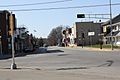
Looking west at downtown Hortonville
-
Looking east at downtown Hortonville
-
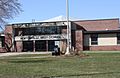
Hortonville High School
-
Welcome sign
-
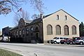
Hortonville Community Hall, a historic building


See also
 In Spanish: Hortonville (Wisconsin) para niños
