
Ins, Switzerland facts for kids
Quick facts for kids
Ins
|
||
|---|---|---|

Swiss Reformed Church in Ins
|
||
|
||

Ins
Location in Switzerland

Ins
Location in Canton of Bern
|
||
| Country | Switzerland | |
| Canton | Bern | |
| District | Seeland | |
| Area | ||
| • Total | 23.87 km2 (9.22 sq mi) | |
| Elevation | 437 m (1,434 ft) | |
| Population
(Dec 2020 )
|
||
| • Total | 3,560 | |
| • Density | 149.14/km2 (386.3/sq mi) | |
| Postal code |
3232
|
|
| Surrounded by | Bas-Vully (FR), Brüttelen, Cudrefin (VD), Erlach, Gampelen, Haut-Vully (FR), Lüscherz, Marin-Epagnier (NE), Müntschemier, Tschugg, Vinelz | |

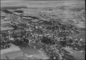
Ins (pronounced eens in German, or an-ett in French) is a town in Switzerland. It is located in the Seeland area of the canton of Bern.
Contents
History of Ins
Ins was first mentioned in old records in the year 1009. Back then, it was called Anestre. Later, in 1179, it was known as Anes.
Ancient Times and Early Settlements
People have lived in the area around Ins since at least the Iron Age. This was a time when people started using iron tools and weapons. On a hill called Schaltenrain, archaeologists have found many ancient graves. These graves include tumuli, which are mounds of earth built over burials. Some of these grave mounds stretch for about 2 kilometers (1.2 miles).
The first big dig was in 1848 by Gustav von Bonstetten. He found many interesting items. The most exciting find was in one mound, which held two "wagon graves" from the 7th century BC. These graves belonged to the Hallstatt culture, an early Iron Age culture. They contained parts of wagons and valuable gold objects. These gold items showed Etruscan influences, meaning they might have come from Italy through trade. Other treasures found included jewelry made of glass, amber, and bronze. An iron sword from the La Tène culture (5th century BC) was also discovered. All these rich finds suggest that Ins was a wealthy and important settlement. It traded a lot with places around the Mediterranean Sea.
Roman Era and Middle Ages
During the Roman era, many settlements were built in the area. They stretched from the Grosses Moos marsh up to the hills covered in vineyards. A Roman road also ran through the marsh. This road connected these settlements to larger Roman towns on the Swiss Plateau.
In the Middle Ages, a castle called Fenis Castle was built on Hasenburg hill, which is now part of Ins. This castle was home to the Counts of Fenis. Later, Ins became part of the Herrschaft of Erlach, which was a type of territory ruled by a lord.
During the Burgundian Wars, the village of Ins became part of Bern. Under Bern's rule, Ins remained an important local center. The old town hall, called the Rathaus, was used as a court until it burned down in 1848.
Churches and Local Life
The village church, St. Mary, was first mentioned in 1228. It was a Romanesque style building. It was likely built on an even older church site. The church was rebuilt in the 16th and 17th centuries. Before the Protestant Reformation in the 16th century, the Cathedral of Bern had special rights over the church.
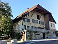
Historically, Ins was surrounded by large vineyards. The nearby Grosses Moos marsh was also important for peat, which was used as fuel. Wealthy landowners built beautiful manor houses in the village during the 17th and 18th centuries. Some of these still stand today, like the Schlössli and Lilienhof.
Geography of Ins
Ins covers an area of about 23.9 square kilometers (9.2 square miles). A large part of this land, about 66.8%, is used for farming. Forests cover about 21.0% of the area. Buildings and roads make up about 9.6% of the land. Rivers and lakes cover 1.6%, and 1.3% is unproductive land.
Ins is located on the southern side of the Schaltenrain hill, which is 592 meters (1,942 feet) high. It also stretches across part of the Grand Marais, a very fertile area with dark soil in the Bernese Seeland. To the south, Ins is bordered by Lake Neuchatel and the Broye Canal. The municipality also includes a small settlement called Witzwil im Moos and several scattered farmhouses.
Even though Ins is a small town, it acts as a hub for the even smaller communities nearby. It is at the end of the Bienne-Täuffelen-Ins (BTI) train line. It also has a bus service that connects it to Erlach.
In 2010, Ins became part of a new administrative area called Verwaltungskreis Seeland.
Coat of Arms of Ins
The coat of arms for Ins shows a golden shield with a red star in the middle. Below the star, there is a blue ploughshare (the blade of a plow) and a blue sickle (a curved blade for cutting crops). These tools are placed over three green hills. This design likely represents the farming history and landscape of the area.
Population and People of Ins
Ins has a population of about 3,700 people. As of 2010, about 15% of the people living in Ins were foreign nationals. Over the past ten years (2000-2010), the population of Ins grew by 16.2%. Most of this growth was due to people moving into the town.
Languages Spoken
Most people in Ins speak German as their main language. In 2000, about 91.1% of the population spoke German. French is the second most common language, spoken by about 3.6% of the people. Albanian is the third most common, spoken by about 1.0%. A small number of people also speak Italian or Romansh.
Age Groups and Families
As of 2008, about 47.8% of the population was male and 52.2% was female. In 2010, children and teenagers (ages 0–19) made up 22.8% of the population. Adults (ages 20–64) made up 60%, and seniors (over 64) made up 17.2%.
In 2000, about one-third of the people in Ins (33.6%) were born there. Another third (33.2%) were born in the same canton of Bern. About 18.9% were born elsewhere in Switzerland, and 11.0% were born outside Switzerland.
Housing in Ins
In 2000, there were 334 households with only one person. There were also 73 households with five or more people. Most apartments (90.9%) were lived in all the time. A small number (5.5%) were used only during certain seasons, and 3.6% were empty. In 2010, 13 new homes were built for every 1000 residents.
The chart below shows how the population of Ins has changed over the years:

Important Heritage Sites in Ins
Several places in Ins are considered very important for their history and culture. These are called heritage sites of national significance. They include:
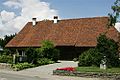
- The Albert Anker house
- The farm house Himmelriich
- The old earthen defenses at Fenis
The entire village of Ins is also part of the Inventory of Swiss Heritage Sites. This means the whole village is protected for its historical value.
-
Albert Anker House
-
Farm House (Himmelriich)
-
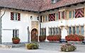
Parish Hall in Ins BE

.jpg)

Economy and Jobs in Ins

In 2011, the unemployment rate in Ins was very low, at 1.51%. This means most people who wanted to work had a job. In 2008, there were 1,487 people working in Ins.
Types of Jobs
Jobs are often grouped into three main types:
- Primary sector: These jobs involve getting raw materials from nature. In Ins, this includes farming and forestry. About 234 people worked in this sector.
- Secondary sector: These jobs involve making things. This includes manufacturing (like factories) and construction (building things). About 231 people worked in this sector.
- Tertiary sector: These jobs involve providing services to people. This is the largest sector in Ins, with 1,022 people working here. Examples include:
- Sales and retail (shops)
- Transportation and storage
- Hotels and restaurants
- Information technology
- Insurance and finance
- Technical and scientific jobs
- Education (teachers)
- Health care (doctors, nurses)
In 2000, many people who lived in Ins worked outside the municipality (832 people). Fewer people came into Ins to work (589 people). This means more people leave Ins for work than come in. About 18.2% of working people used public transportation, and 43.3% used a private car to get to work.
Religion in Ins
Based on the 2000 census, most people in Ins belong to the Swiss Reformed Church (71.8%). About 11.7% were Roman Catholic. Other groups included Orthodox Christians and other Christian churches. A small number of people were Islamic. About 7.4% of the population did not belong to any church.
Education in Ins
In Ins, many people have completed higher levels of education. About 37.9% of the population finished upper secondary education, which is like high school. About 13.5% went on to get a university degree or similar higher education.
School System
The school system in the Canton of Bern works like this:
- One year of optional Kindergarten.
- Six years of Primary school.
- Three years of mandatory lower Secondary school. Students are grouped by their abilities.
- After secondary school, students can continue their education or start an apprenticeship (learning a trade on the job).
During the 2010–11 school year, 625 students attended schools in Ins.
- There were 3 kindergarten classes with 69 students.
- There were 12 primary classes with 244 students.
- There were 12 lower secondary classes with 240 students.
Some students in Ins schools were foreign residents, or spoke a different language at home than the classroom language.
Ins also has a library called Bibliothek Ins. In 2008, it had over 8,500 books and other items. It loaned out almost 34,000 items that year.
Transportation in Ins
Ins has two train stations: Ins and Ins Dorf. The main Ins station is a busy place where different train lines meet. You can catch trains to Bern, La Chaux-de-Fonds, Neuchâtel, Fribourg/Freiburg, and Biel/Bienne. Ins Dorf station is located in the center of Ins and is on the Biel–Täuffelen–Ins line.
Famous Residents of Ins
The famous Swiss painter and illustrator Albert Anker lived in Ins until he passed away in 1910.
See also
 In Spanish: Ins para niños
