Inyokern, California facts for kids
Quick facts for kids
Inyokern
|
|
|---|---|

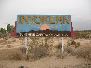
Inyokern entrance sign
|
|
| Nickname(s):
Sunshine Capital of America
|
|

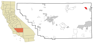
Location in Kern County and the state of California
|
|
| Country | |
| State | |
| County | Kern |
| Area | |
| • Total | 10.918 sq mi (28.279 km2) |
| • Land | 10.917 sq mi (28.276 km2) |
| • Water | 0.001 sq mi (0.003 km2) 0.01% |
| Elevation | 2,434 ft (742 m) |
| Population | |
| • Total | 988 |
| • Density | 90.49/sq mi (34.938/km2) |
| Time zone | UTC-8 (Pacific) |
| • Summer (DST) | UTC-7 (PDT) |
| ZIP code |
93527
|
| Area codes | 442/760 |
| FIPS code | 06-36658 |
| GNIS feature IDs | 243875, 2408430 |
Inyokern is a small community in Kern County, California, United States. It was once called Siding 16 and Magnolia. Its name comes from being close to the border between Inyo and Kern Counties.
Inyokern is about 8 miles (13 km) west of Ridgecrest. It sits at an elevation of 2,434 feet (742 meters). This town is on the western side of the Indian Wells Valley. In 2020, about 988 people lived here.
Inyokern started as a railroad town. It was built along the Southern Pacific railroad line, which is now gone. During World War II, it became home to the Naval Air Weapons Station China Lake. Today, Inyokern Airport serves the area.
Contents
Geography of Inyokern
Inyokern is located at 35°38′49″N 117°48′45″W. It is about 8 miles (13 km) west of Ridgecrest. The town is 2,434 feet (742 meters) above sea level. It lies on the western edge of the Indian Wells Valley. The eastern slopes of the Sierra Nevada mountains rise to the west.
The town is on U.S. Route 395. This is a major road that connects the Inland Empire to Reno, Nevada. You can also reach Los Angeles from Inyokern using U.S. Route 395 and State Route 14.
State Route 178 is another important road. It connects Inyokern to Bakersfield in the west. Bakersfield is the county seat. To the east, State Route 178 leads to Death Valley through Ridgecrest.
The community covers about 10.9 square miles (28.2 square kilometers). Almost all of this area is land.
People of Inyokern
| Historical population | |||
|---|---|---|---|
| Census | Pop. | %± | |
| U.S. Decennial Census | |||
Inyokern is home to a diverse group of people. In 2010, the population was 1,099. Most residents were White, with smaller numbers of African American, Native American, and Asian people. About 10.6% of the population identified as Hispanic or Latino.
The community has a mix of families and individuals. Many people own their homes here. The average household size was about 2.27 people. The average family size was about 3.01 people.
The population includes people of all ages. In 2010, about 20.2% of residents were under 18. About 17.8% were 65 or older. The median age was 48.2 years, meaning half the population was older and half was younger than this age.
Climate and Weather
Inyokern has a high desert climate. This means it has hot days and cool nights. The area is very dry, especially during the summer months.
The average yearly temperature in Inyokern is about 70°F (21°C). Temperatures can change a lot throughout the year. They can go as high as 118°F (48°C) and as low as 8°F (-13°C).
January is the coolest month. The average high is 47°F (8°C) and the average low is 22°F (-6°C). The coldest temperature ever recorded was -12°F (-24°C) in December 1972 and January 1973.
July is the hottest month. The average high is 108°F (42°C) and the average low is 80°F (27°C). The hottest temperature ever recorded was 118°F (48°C) on July 31, 1985.
Inyokern is a desert area. It gets less than 5 inches (127 mm) of rain each year. This includes less than 2 inches (5 cm) of snow.
| Climate data for Inyokern, California | |||||||||||||
|---|---|---|---|---|---|---|---|---|---|---|---|---|---|
| Month | Jan | Feb | Mar | Apr | May | Jun | Jul | Aug | Sep | Oct | Nov | Dec | Year |
| Record high °F (°C) | 80 (27) |
86 (30) |
93 (34) |
100 (38) |
112 (44) |
114 (46) |
119 (48) |
114 (46) |
110 (43) |
105 (41) |
88 (31) |
84 (29) |
119 (48) |
| Mean daily maximum °F (°C) | 59.6 (15.3) |
64.8 (18.2) |
70.3 (21.3) |
77.7 (25.4) |
87.0 (30.6) |
96.7 (35.9) |
102.7 (39.3) |
101.2 (38.4) |
94.2 (34.6) |
83.2 (28.4) |
69.0 (20.6) |
59.7 (15.4) |
80.5 (27.0) |
| Mean daily minimum °F (°C) | 30.8 (−0.7) |
34.6 (1.4) |
38.7 (3.7) |
44.3 (6.8) |
52.9 (11.6) |
60.5 (15.8) |
66.2 (19.0) |
64.6 (18.1) |
58.1 (14.5) |
48.2 (9.0) |
37.3 (2.9) |
30.2 (−1.0) |
47.2 (8.4) |
| Record low °F (°C) | 1 (−17) |
9 (−13) |
15 (−9) |
21 (−6) |
26 (−3) |
38 (3) |
46 (8) |
45 (7) |
35 (2) |
20 (−7) |
14 (−10) |
5 (−15) |
1 (−17) |
| Average precipitation inches (mm) | 0.74 (19) |
0.95 (24) |
0.55 (14) |
0.17 (4.3) |
0.07 (1.8) |
0.02 (0.51) |
0.16 (4.1) |
0.22 (5.6) |
0.20 (5.1) |
0.10 (2.5) |
0.38 (9.7) |
0.59 (15) |
4.15 (105.61) |
| Average snowfall inches (cm) | 0.3 (0.76) |
0.0 (0.0) |
0.1 (0.25) |
0.0 (0.0) |
0.0 (0.0) |
0.0 (0.0) |
0.0 (0.0) |
0.0 (0.0) |
0.0 (0.0) |
0.0 (0.0) |
0.0 (0.0) |
0.2 (0.51) |
0.6 (1.52) |
History of Inyokern
Inyokern began in the mid-1800s as a farming community. It was located in the northern part of the Mojave Desert. The town grew when the Owens Valley aqueduct was being built. The first post office opened in 1910.
The Inyokern Elementary School started in 1913. The original school building was replaced in the mid-1930s. The new building was larger and had a stage and indoor restrooms. This building was torn down in the early 1970s.
In the 1930s, there were several farms around the Indian Wells Valley. They mostly grew alfalfa and raised animals. Community events were held at Inyokern Hall, which is still standing today.
During World War II, the U.S. Navy built the Naval Air Weapons Station China Lake in Inyokern. This is why the local airport has such long runways. Later, the military base moved about 12 miles (19 km) east. The city of Ridgecrest was then built to support the base.
Inyokern Today
Today, Inyokern is a quiet community. Many people who work at the nearby naval base live here because they prefer a more rural lifestyle.
The town has several services and businesses. These include two churches, a post office, a market, and gas stations. There is also a variety store, a hardware store, and a welding shop. You can find a county park, two restaurants, a motel, and some antique shops.
In the 1990s, the old library building was replaced by a Senior Citizen's Center. Inyokern also used to have a local sheriff's office and a road maintenance center.
The town's population grew around 1988 when the naval base expanded. However, it has become smaller since then. Many properties were left empty when the military reduced its size in the 1990s.
The main shopping area along Highway 178 used to be a charming street. It had older buildings made of local rock and bricks. These included a vintage post office, a cafe, and a small Chinese restaurant. This street is sometimes used to film Hollywood western movies. The Inyokern Airport is also a popular place for filming car commercials.
Nature and Wildlife
Inyokern is in a wide, very dry valley. It is at the base of the eastern side of the Sierra Nevada mountains. The tall mountains to the west block rain. This creates a "rain-shadow effect," meaning the area gets less than 3 inches (76 mm) of rain each year.
The plants on the valley floor are mostly Creosote Bush (Larrea tridentata) and Burrobush (Ambrosia dumosa). There are also different kinds of native grasses. In the nearby foothills, you can find pinyon pine trees and Joshua tree forests. Small streams coming down from the mountains also have areas with lots of plants.
The wildlife in the area is varied. In the mountains, you might see black bears, mountain lions, and whitetail deer. On the valley floor, you can find kangaroo rats and the endangered desert tortoise.
A special animal in the area is the Mojave rattlesnake. This snake is common here. It has venom that can paralyze its victim quickly. However, this type of rattlesnake is usually calm, and serious bites are rare. Other animals found on the valley floor include kit foxes, coyotes, bobcats, and roadrunners. Sometimes, bears and mountain lions come down from the Sierra Nevada Mountains looking for food.
Fun Facts and Attractions
Inyokern gets a lot of sunshine! As of 2008, it had the most sunshine of any place in North America. It gets over 355 sunny days every year.
The town is also known for its musical talent. As of 2018, Inyokern was home to both past and current world champion musical saw players.
The Inyokern Airport is a popular spot for filming car commercials. The beautiful Sierra Nevada mountains in the background make it a great setting.
Getting Around
- Inyokern Airport
- Kern Transit (bus service)
- Eastern Sierra Transit (bus service)
Churches
- Bethel Missionary Baptist Church
- Inyokern Baptist Church
- Inyokern Community Methodist Church
Local Media
Inyokern has two local newspapers: The Daily Independent and the News Review. Residents can also listen to local radio stations and watch TV stations from Los Angeles, California.
Radio Stations
- KLOA (1240 AM)
- KZIQ-FM (92.7 FM)
- KLOA-FM (104.9 FM)
- KRAJ (100.9 FM)
Notable People
- Lorien Stern, an artist
See also
 In Spanish: Inyokern para niños
 | Madam C. J. Walker |
 | Janet Emerson Bashen |
 | Annie Turnbo Malone |
 | Maggie L. Walker |


