Jerilderie facts for kids
Quick facts for kids JerilderieNew South Wales |
|||||||||
|---|---|---|---|---|---|---|---|---|---|
| Population | 922 (2021 census) | ||||||||
| • Density | 0.27/km2 (0.70/sq mi) | ||||||||
| Established | 1859 | ||||||||
| Postcode(s) | 2716 | ||||||||
| Area | 3,375.4 km2 (1,303.2 sq mi) | ||||||||
| Time zone | AEST (UTC+10) | ||||||||
| • Summer (DST) | AEDT (UTC+11) | ||||||||
| Location |
|
||||||||
| LGA(s) | Murrumbidgee Council | ||||||||
| Council seat | Coleambally | ||||||||
| Region | Riverina | ||||||||
| County | Urana | ||||||||
| State electorate(s) | Murray | ||||||||
| Federal Division(s) | Farrer | ||||||||
| Website | Jerilderie | ||||||||
|
|||||||||
Jerilderie is a small country town in the Riverina region of New South Wales, Australia. It's part of the Murrumbidgee Council area. In 2021, about 922 people lived there.
You can find Jerilderie along the Newell Highway, about 674 kilometers (419 miles) west-southwest of Sydney. It's also just 45 kilometers (28 miles) north of the Victorian state border.
This town is famous for a visit by the legendary bushranger Ned Kelly and his gang in 1879. During their visit, they robbed the local bank, held people hostage, and even locked the police in their own jail!
Contents
What is Jerilderie Like?
Jerilderie is a busy farming center, especially known for its irrigation systems. A huge amount of Australia's tomatoes come from this area. It's also a top spot for raising Merino sheep.
Farmers in Jerilderie grow many different crops. These include rice, olives, wheat, canola, mung beans, soybeans, onions, liquorice, and grapes. There are also many cattle farms here.
The town has two primary schools: Jerilderie Public School and Jerilderie Catholic School. For fun, there's an 18-hole golf course and three pubs. The local hospital was the first in regional Australia to use solar power. It has been rebuilt into a modern medical center with an emergency room and aged care beds.
Jerilderie also has an Australian rules football team. They play in the Picola & District Football League.
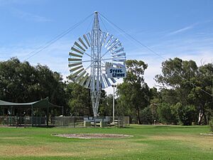
The Unique Steel Wings Windmill
Jerilderie is home to a very rare and unusual windmill. It's located right on National Route 39, a main road connecting Victoria to Queensland.
This windmill was made by the Steel Wings Company in North Sydney between 1907 and 1911. Only six of these special windmills were ever built. They have a steel frame and a fan that spins inside the frame. The whole structure can turn to face the wind.
The Jerilderie Steel Wings windmill was built in 1910. It was brought by train from Sydney and then by bullock wagon to Goolgumbula Station. It helped provide water to the station's buildings and dams through a 43-kilometer (27-mile) channel system.
In 1977, a storm damaged the mill. It was then given to the town as a historical display and placed in Luke Park. This park was named after Thomas Raymond Luke, who helped create the nearby Jerilderie Lake.
In 1989, local community groups like Lions and Apex, along with the Jerilderie Shire Council, worked to fix the windmill. Two people spent about 600 hours to get it working again. Today, it pumps 9 liters (2.4 US gallons) of water per revolution from the Billabong Creek into Jerilderie Lake. The Jerilderie windmill is 17 meters (56 feet) tall and has a 9-meter (30-foot) fan. It's one of only two working examples of this type of windmill in the world.
Famous People from Jerilderie
Ned Kelly's Visit

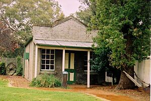
Ned Kelly and his gang visited Jerilderie in 1879. They captured the town's two policemen and locked them in their own jail cell. Then, the gang members put on the police uniforms. They told the townspeople they were police sent from Sydney to protect them from the Kelly Gang!
Later, the gang robbed the local bank, stealing over two thousand pounds. After that, Kelly and his gang went to the Telegraph Office and cut down the telegraph poles. They held 30 people hostage overnight at the Royal Mail Hotel. While there, Ned Kelly wrote his famous Jerilderie Letter. This letter shares Kelly's strong feelings about being innocent and wanting fairness for his family and other poor Irish settlers. It's a very important document because it's the only direct message from the Kelly Gang explaining their actions.
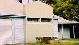
The current Jerilderie Police Station has 19 parts that look like Ned Kelly's famous armor face plate. For example, some walls are made of different colored bricks that form his image.
Sir John Monash
Jerilderie was the childhood home of Sir John Monash. He was a very important military commander. You can even see his picture on the Australian one hundred dollar note. He went to Jerilderie Public School and was the top student. You can see his name on a board in the school's main office. The Sir John Monash Memorial Drive, named in his honor, is just outside town on the way to Finley.
Lord Loudoun
In the early 2000s, a scholar named Dr. Michael Jones made an interesting claim. He said that Queen Elizabeth's right to the throne might not be correct. He believed that King Edward IV, who ruled from 1461 to 1483, was not truly royal. Dr. Jones suggested that the real king should have been The 14th Earl of Loudoun, who lived in Jerilderie from the 1960s.
Billy Brownless
Jerilderie is also where former AFL Geelong player Billy Brownless grew up. He is now a regular on The AFL Footy Show and The Sunday Footy Show. He also co-hosts a popular radio show called The Rush Hour on Triple M in Melbourne.
Jerilderie's History
Before Europeans arrived, the Jerilderie area was home to the Jeithi Aborigines. The name 'Jerilderie' likely comes from their word for 'reedy place'.
The town of Jerilderie began when John Carractacus Powell built a house and store in 1854. He was helped by the Kennedy Family, who owned the Mary's Creek Run station around the town site. In 1859, William Davidson settled in the "Cape" region of Jerilderie. He built a brick kiln, a house, a hotel, and a blacksmith shop.
For a while, Jerilderie had two main settlements about three kilometers apart. Both tried to attract travelers and their business. A Mr. Cadell later opened another store, adding to the competition.
The Post Office opened on 1 October 1862. It was spelled Jereelderie until 1890.
In 1865, the Village of Jerilderie was officially recognized. It covered an area of about 195 acres (79 hectares). As the town grew, especially with the sheep and wool industry, there was a need for local services. So, in 1889, the Jerilderie Municipal Council was formed to manage things like roads and water.
Later, in 1906, the Wunnamurra Shire Council was created for the landholders outside the town. In 1918, these two councils joined together to form the Shire of Jerilderie. In 2016, the Jerilderie Shire became part of the new Murrumbidgee Council.
Climate in Jerilderie
Jerilderie has a cold semi-arid climate. This means it has hot summers with clear skies and cool to cold winters with some clouds. The temperature changes a lot between seasons.
| Climate data for Jerilderie Treatment Works (1914−1975, rainfall 1886−2024); 110 m AMSL; 35.35° S, 145.73° E | |||||||||||||
|---|---|---|---|---|---|---|---|---|---|---|---|---|---|
| Month | Jan | Feb | Mar | Apr | May | Jun | Jul | Aug | Sep | Oct | Nov | Dec | Year |
| Mean daily maximum °C (°F) | 32.9 (91.2) |
32.4 (90.3) |
29.2 (84.6) |
23.6 (74.5) |
18.7 (65.7) |
14.8 (58.6) |
14.2 (57.6) |
16.0 (60.8) |
19.8 (67.6) |
23.5 (74.3) |
27.7 (81.9) |
31.1 (88.0) |
23.7 (74.6) |
| Mean daily minimum °C (°F) | 16.3 (61.3) |
16.3 (61.3) |
14.0 (57.2) |
9.4 (48.9) |
6.1 (43.0) |
3.6 (38.5) |
3.2 (37.8) |
4.1 (39.4) |
6.3 (43.3) |
8.8 (47.8) |
11.8 (53.2) |
14.6 (58.3) |
9.5 (49.2) |
| Average rainfall mm (inches) | 28.7 (1.13) |
26.6 (1.05) |
30.5 (1.20) |
29.1 (1.15) |
37.9 (1.49) |
39.1 (1.54) |
34.6 (1.36) |
37.7 (1.48) |
34.4 (1.35) |
38.9 (1.53) |
32.6 (1.28) |
31.2 (1.23) |
401.0 (15.79) |
| Average rainy days (≥ 0.2 mm) | 3.8 | 3.5 | 4.0 | 4.7 | 6.5 | 8.4 | 8.7 | 8.6 | 6.8 | 6.1 | 4.8 | 4.0 | 69.9 |
| Source 1: Urana Post Office (temperatures and rainy days, 1914–1975) | |||||||||||||
| Source 2: Jerilderie Treatment Works (rainfall, 1886–2024) | |||||||||||||
Heritage Sites
Jerilderie has some places that are listed for their historical importance. One of these is:
- Nowranie Street: Jerilderie railway station
Jerilderie's Railway Line
The Tocumwal railway line used to connect Jerilderie to Narrandera in the north and Tocumwal in the south. This line opened to Jerilderie in 1884. It was later extended to Berrigan in 1896, Finley in 1898, and Tocumwal in 1914. The line south of Jerilderie closed in 1986, and the northern part closed in 1988.
Jerilderie's Population
In the 2016 Census, there were 1,029 people living in Jerilderie. Most people (76.4%) were born in Australia. Also, 82.3% of people spoke only English at home. The most common religions reported were Catholic (34.1%), Anglican (17.4%), and No Religion (15.7%).


