Johnson County, Indiana facts for kids
Quick facts for kids
Johnson County
|
|
|---|---|

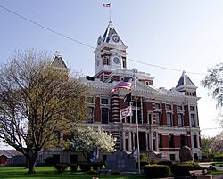
Johnson County courthouse in Franklin, Indiana
|
|

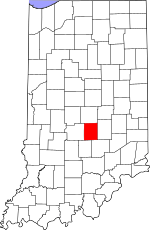
Location within the U.S. state of Indiana
|
|
 Indiana's location within the U.S. |
|
| Country | |
| State | |
| Founded | 1823 |
| Seat | Franklin |
| Largest city | Greenwood |
| Area | |
| • Total | 321.79 sq mi (833.4 km2) |
| • Land | 320.43 sq mi (829.9 km2) |
| • Water | 1.36 sq mi (3.5 km2) 0.42%% |
| Population
(2020)
|
|
| • Total | 161,765 |
| • Estimate
(2023)
|
167,819 |
| • Density | 502.704/sq mi (194.095/km2) |
| Time zone | UTC−5 (Eastern) |
| • Summer (DST) | UTC−4 (EDT) |
| Congressional district | 6th |
| Indiana county number 41 | |
Johnson County is a county located in the state of Indiana, USA. It's found just south of the big city of Indianapolis. In 2020, about 161,765 people called Johnson County home.
The main town, or county seat, where the county government is located, is Franklin. Johnson County is also part of the larger Indianapolis metropolitan area. This means it's connected to the bigger cities of Indianapolis, Carmel, and Anderson.
Contents
Getting Around Johnson County
This section tells you about the ways people travel in and out of Johnson County.
Local Transit
- Access Johnson County is a service that helps people get around the county.
Main Roads
Several important roads run through Johnson County, making it easy to travel to other parts of Indiana.
 Interstate 65
 Interstate 69
 U.S. Route 31
 State Road 44
 State Road 135
 State Road 144
 State Road 252
Airports
For air travel, Johnson County has two smaller airports:
- KHFY - Greenwood Municipal Airport
- 3FK - Franklin Flying Field
Johnson County's Location
Johnson County covers about 321.79 square miles. Most of this area, about 320.43 square miles, is land. The rest, about 1.36 square miles, is water.
Neighboring Counties
Johnson County shares its borders with several other counties:
- Marion County to the north
- Shelby County to the east
- Bartholomew County to the southeast
- Brown County to the southwest
- Morgan County to the west
A Look at Johnson County's Past
Johnson County was officially created in the year 1823. It was named after John Johnson. He was an important judge on the Indiana Supreme Court. He was likely the same John Johnson from Knox County.
Towns and Cities in Johnson County
Johnson County is home to several vibrant cities and towns:
One town that used to exist but is no longer active is Farwest.
Understanding Townships
Counties in Indiana are divided into smaller areas called townships. Johnson County has several townships:
- Blue River
- Clark
- Franklin-Union-Needham (these three joined together in January 2022)
- Hensley
- Nineveh
- Pleasant
- White River
The southern part of Johnson County is also where you'll find Camp Atterbury. This is a large military training base.
Weather in Johnson County
| Weather chart for Franklin, Indiana | |||||||||||||||||||||||||||||||||||||||||||||||
|---|---|---|---|---|---|---|---|---|---|---|---|---|---|---|---|---|---|---|---|---|---|---|---|---|---|---|---|---|---|---|---|---|---|---|---|---|---|---|---|---|---|---|---|---|---|---|---|
| J | F | M | A | M | J | J | A | S | O | N | D | ||||||||||||||||||||||||||||||||||||
|
3.1
36
21
|
2.4
41
24
|
3.7
52
34
|
4.3
64
43
|
4.8
73
54
|
5
82
63
|
4.4
86
66
|
3.2
84
65
|
3.1
78
57
|
3.2
66
46
|
3.5
52
35
|
2.9
40
26
|
||||||||||||||||||||||||||||||||||||
| temperatures in °F precipitation totals in inches source: The Weather Channel |
|||||||||||||||||||||||||||||||||||||||||||||||
|
Metric conversion
|
|||||||||||||||||||||||||||||||||||||||||||||||
The weather in Franklin, a main town in Johnson County, changes throughout the year. In January, the average low temperature is about 21°F (around -6°C). In July, the average high temperature reaches about 86°F (around 30°C).
The coldest temperature ever recorded in Franklin was -22°F (-30°C) in January 1985. The hottest was 104°F (40°C) in June 1988. The town of New Whiteland, Indiana, which is also in Johnson County, holds the record for the coldest temperature ever in Indiana. It reached -36°F (-38°C) on January 19, 1994!
Population of Johnson County
| Historical population | |||
|---|---|---|---|
| Census | Pop. | %± | |
| 1830 | 4,019 | — | |
| 1840 | 9,352 | 132.7% | |
| 1850 | 12,101 | 29.4% | |
| 1860 | 14,854 | 22.8% | |
| 1870 | 18,366 | 23.6% | |
| 1880 | 19,537 | 6.4% | |
| 1890 | 19,561 | 0.1% | |
| 1900 | 20,223 | 3.4% | |
| 1910 | 20,394 | 0.8% | |
| 1920 | 20,739 | 1.7% | |
| 1930 | 21,706 | 4.7% | |
| 1940 | 22,493 | 3.6% | |
| 1950 | 26,183 | 16.4% | |
| 1960 | 43,704 | 66.9% | |
| 1970 | 61,138 | 39.9% | |
| 1980 | 77,240 | 26.3% | |
| 1990 | 88,109 | 14.1% | |
| 2000 | 115,209 | 30.8% | |
| 2010 | 139,654 | 21.2% | |
| 2020 | 161,765 | 15.8% | |
| 2023 (est.) | 167,819 | 20.2% | |
| U.S. Decennial Census 1790–1960 1900–1990 1990–2000 2010–2020 |
|||
Johnson County has grown a lot over the years! In 2010, about 139,654 people lived here. By 2020, the population had grown to 161,765 people. This means more and more families are choosing to live in Johnson County.
Most households in the county are made up of families. Many of these families have children under 18 living with them.
Schools in Johnson County
Johnson County has several school districts that serve its communities. These districts help make sure students get a good education.
- Center Grove Community School Corporation
- Clark-Pleasant Community School Corporation
- Edinburgh Community School Corporation
- Franklin Community School Corporation
- Greenwood Community School Corporation
- Nineveh-Hensley-Jackson United School Corporation
See also
 In Spanish: Condado de Johnson (Indiana) para niños

