
Karioi facts for kids
Quick facts for kids Mount Karioi |
|
|---|---|

Mt. Karioi, Raglan and Whaingaroa Harbour (February 2012)
|
|
| Highest point | |
| Elevation | 756 m (2,480 ft) |
| Naming | |
| English translation | to loiter or idle |
| Language of name | Māori |
| Geography | |

Mount Karioi
Location in New Zealand
|
|
| Topo map | BD32 Raglan |
| Geology | |
| Age of rock | Pliocene |
| Mountain type | Stratovolcano (extinct) |
| Climbing | |
| Easiest route | from Ruapuke Rd |
Mount Karioi is an ancient, extinct volcano located about 8 kilometers southwest of Raglan in New Zealand's Waikato region. It's a huge mountain that forms a beautiful backdrop to many parts of Raglan.
Karioi is about 2.4 million years old. It was the first of a chain of six volcanoes in the area. The biggest one is Mount Pirongia.
For a while, from 1870 to 1889, the area around Mount Karioi was managed by a local board. Later, it became part of the Raglan County Council.
Contents
History and Culture of Mount Karioi
Māori History and Legends

Many iwi (Māori tribes) have strong connections to Karioi. The mountain is important in several Māori legends.
One famous story tells of Karewa, who was the husband of Karioi. He was said to have flirted with Karioi's sister, Pirongia. Because of this, Karewa was turned into a rock in the sea. This rock is now known as Gannet Island.
From Raglan, the shape of Karioi looks like a 'Sleeping Lady' (Wahine Moe).
European Explorers and Settlers
The first Europeans to see Karioi were explorers. On December 28, 1642, Abel Tasman saw a "high mountain east by north of us." He later realized it was part of a long coastline.
Then, on January 11, 1770, Captain Cook sailed past. He described the land as "of moderate height and cloathed with wood and verdure." He named a nearby spot "Woody Head" and the small island offshore "Gannet Island" because of all the birds he saw there.
Later, in the 1850s, European settlers began to arrive. Land was purchased from Māori tribes. In 1854, a large area called the Karioi Block, which included the entire mountain, was bought. A special area of 600 acres was set aside for the Māori owners. The land was bought for a price that was considered fair at the time, given how much of it was mountainous and covered in forest.
Roads were built to help settlers move into the area. One important road, Whaanga Road, goes around the coastal side of Karioi. It was first thought about in 1886 but wasn't fully built until 1953.
Timber mills were also set up around Karioi. They cut down trees like rimu, which were common on the mountain's eastern slopes. However, a big fire in 1928 destroyed a sawmill and much of the forest. The last mills closed in the late 1930s.
Modern Management
Since 1987, the Department of Conservation (DOC) has looked after Karioi. It is now part of Pirongia Forest Park.
Marae Near Karioi
A marae is a traditional Māori meeting place. The closest marae to Mount Karioi is Poihākena, located on the edge of Raglan. To the south, there is also Mōtakotako marae.
Geology of Mount Karioi

Mount Karioi is an extinct volcano. It's the oldest and westernmost volcano in a line of volcanoes in the area. About two million years ago, Karioi was likely an ash cone, possibly even taller than its current height of 756 meters.
The mountain is mostly made of a type of rock called basalt. It also has andesite dikes, which are like walls of rock that pushed through older layers about 2.4 million years ago. The main chemicals in these rocks are silica and alumina.
Te Toto Gorge

Te Toto Gorge has cliffs that are 150 meters high. You can see 15 different lava flows in these cliffs! There are also large crystals of a mineral called augite.
On the north side of the gorge, you can find old Māori stone gardens. There's a steep, unmarked path that leads into the gorge from the road.
Two rare plants, Hebe speciosa and Cook's scurvy grass, have been brought back to Te Toto Gorge.
Vegetation on Mount Karioi
Captain Cook called Karioi "Woody Head" because it was covered in trees. Karioi is special because it has a native rainforest that goes from sea level all the way up to the mountain top. It gets a lot of rain every year, which helps the forest grow.
The original forest in the area had huge trees like totara, matai, rimu, and kahikatea. Much of this forest was cut down or burned in the early 1900s. However, some of it still remains on Karioi.
Since the 1960s, possums have caused a lot of damage. They eat the leaves of big trees, which can kill them. You can still see the bare trunks of trees that possums have killed.

The types of plants on Karioi change as you go higher up the mountain and depending on how much wind they get. For example, near Te Toto Gorge, you'll find kohekohe trees. Higher up, you'll see tawa forest, and closer to the top, kamahi and tāwheowheo.
Even with the damage, Karioi still has many different plant communities. Over 127 native plant species have been found above 300 meters, and 264 below that level. These include many types of ferns like silver fern and kidney fern, and trees like miro and horopito.
In autumn, Karioi is full of interesting fungi, including the bright blue mushroom and the red wax gill fungus.
The weather also affects the plants. Between 550 and 650 meters, there's often a mist line. Many plants reach their upper or lower limit here. Trees become stunted and gnarled because of the clouds and wind. For example, kamahi trees grow tall and straight at lower altitudes but become short and twisted higher up.
Strong, salty winds from the sea also affect what grows where. Some trees, like tawa and rimu, are less common near the coast. Kiekie plants grow in thick tangles in windy spots.
Wildlife on Mount Karioi
Birds
Since the year 2000, the forest on Karioi has gotten healthier. This means more birds like tui, bellbirds, and pigeons are living there. You might even spot a kaka sometimes!
Other birds you can hear are Shining cuckoos, grey warblers, tomtits, and fantails. Traps are set near the cliffs to protect the burrows of grey faced petrels.
Bats (Pekapeka-tou-poto)
The high-pitched squeaks of long-tailed bats have been heard around Karioi.
Lizards (Moko)
Three types of native geckos have been seen on Karioi. Auckland green geckos used to be common before possums arrived. They are bright green and active during the day, but they are very good at hiding in the manuka and kanuka bushes. Forest geckos and Pacific geckos usually live on the ground and are active at night.

Protecting Mount Karioi: Pest Control
Even in the 1950s, people noticed that wild goats were damaging the native plants on Karioi. Since the 1970s, DOC has worked hard to restore Karioi. They do this by reducing the number of introduced animals, like goats and possums. The goal is to help the native plants and animals grow back.
Goats were a big problem because they ate young trees. Now, many trees that were threatened by goats have been saved.
However, possums became a new threat. They love to eat the leaves of trees like northern rata, tree daisy, kohekohe, and kamahi. Many of these trees were killed by possums eating them.
To control possums, most areas of the bush have bait stations. These are linked by pink-marked tracks. Also, poison called 1080 is dropped from the air about every five years. This helps to greatly reduce the possum population. For example, after a drop in 2010, the possum numbers were very low.
A community project called the Karioi Biodiversity Restoration project is also helping. It's a partnership between local groups, DOC, and the community. Volunteers set up and maintain traps for rats, possums, and stoats. By 2020, there were over 2,000 traps and 350 volunteers! In the first three years, they caught hundreds of rats, mice, stoats, possums, and hedgehogs. This work helps protect the native wildlife.
In 2018, a plant disease called myrtle rust was found on some plants, but it has been controlled and is being watched.
Walks and Hikes on Mount Karioi
Beyond Whale Bay, the road becomes unsealed. After crossing Te Toto Gorge, you'll find a car park. A short walk from the car park leads to a viewpoint where you can see the 150-meter-high cliffs of the gorge.
Climbing to the Summit

From the car park, you can climb a DOC track to the 756-meter summit of Karioi. The signs say it takes about 2 hours to reach the 706-meter Lookout and 3 hours to the summit. If you're fit, you can do it in that time, but it's worth taking longer to enjoy the amazing views.
The track is clearly marked, but it gets harder as you go up. There's even a ladder and two chains to help you climb! About halfway up, just before the first chain, there's a great viewpoint.
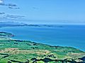
From the lookout, you can see Raglan, the harbor, and the coast stretching north. From the summit, you can see Ruapuke Beach, Aotea and Kāwhia Harbours, and Gannet Island out at sea. On clear days, you might even see Mount Taranaki, which is about 160 kilometers away!
Easier Route from Ruapuke Road
There's an easier way to climb Karioi from Ruapuke Road. This route doesn't have steep drops or chains. The car park is signposted from Ruapuke Road. The track starts on a farm road, then goes up a hill next to a fence and into the bush. The path is clear and marked with orange waymarks.
Tourism on Mount Karioi
In the past, people enjoyed visiting Mount Karioi for its beautiful scenery. A guide from 1915 said that from the summit, you could get a "magnificent view." In 2007, DOC improved the viewing platform at Te Toto Gorge, making it even better for visitors to enjoy the sights.
Images for kids
-
The view south from Karioi summit, to Ruapuke, Taranaki Point on the left, Albatross Point (Honipaka), the Herangi Range and Mount Taranaki

