
Kersal Moor facts for kids
Quick facts for kids Kersal Moor |
|
|---|---|

Kersal Moor, August 2007
|
|
| Highest point | |
| Elevation | 30 ft (9.1 m) to 75 feet (23 m) |
| Geography | |

Kersal Moor
Location in Greater Manchester
|
|
| Location | Kersal, Greater Manchester, England |
| OS grid | SD816021 |
Kersal Moor is a fun outdoor area in Kersal, Greater Manchester, England. It's about eight hectares of open land, like a small moorland. It's surrounded by Moor Lane, Heathlands Road, St. Paul's Churchyard, and Singleton Brook.
This area, first called Karsey or Carsall Moor, used to be much bigger. It even stretched down to the River Irwell. People have found signs that humans lived here way back in the Neolithic period (the New Stone Age). The Romans also used this land.
Kersal Moor was home to the first Manchester Racecourse for horses. It also had the second golf course ever built outside of Scotland! People used the moor for many sports, army training, and big public meetings. One famous meeting was the Great Chartist gathering in 1838. This made a writer named Friedrich Engels call it the "Mons Sacer of Manchester," which means "Sacred Mountain" – a place where common people gathered to protest.
As Manchester and Salford grew with factories and cities in the 1700s and 1800s, Kersal Moor became one of the last natural places. Nature lovers enjoyed exploring it. One person even found the only known examples of a moth species, Euclemensia woodiella, which is now extinct. Today, Kersal Moor is a Site of Biological Importance. In 2007, it became a Local Nature Reserve, which means it's protected for its nature.
Contents
Exploring Kersal Moor's Landscape

Kersal Moor is part of many ridges that formed along the Irwell Valley. These ridges were created when glaciers melted at the end of the last ice age. The ground here is mostly sand mixed with rough gravel.
On top of this sand and gravel, there's a thin layer of soil. This soil supports different plants like mosses, heathers, grasses, ferns, common broom, and gorse. You can also find some trees, mostly oaks, with a few rowan and cherry trees.
The southern part of the moor is higher up. From this high spot, you can see amazing views! You can look across Manchester to the Derbyshire hills in the south. You can also see the Pennines mountains in the north-east and across the Irwell Valley to Salford in the west. The land slopes down to the north, ending with two small, rounded hills. These hills were likely formed by melting ice from the glaciers.
Many footpaths cross the moor. Some of these paths cut through the topsoil, showing the sand and gravel underneath. Singleton Brook, a small stream, runs along the north side of the moor. It marks the border between Salford and Prestwich.
Kersal Moor's Long History
People have found Flint tools like scrapers and knives on the moor. These tools show that humans lived here during the neolithic period, thousands of years ago. The Roman road from Manchester (called Mamucium back then) to Ribchester followed a path close to Kersal Moor. Some people think there might have been a Roman camp on the moor to protect Manchester.
An old historian named John Whitaker wrote about the moor in the 1700s. He said it was once a thick forest of oak trees, where pigs grazed. The small hills on the moor were places where herders would sit and watch their animals. Sadly, the last of these old trees were burned around 1880.
Sports and Games on the Moor

Kersal Moor was home to Manchester's first horse racecourse. The earliest record of horse racing here is from 1687. The racecourse was a large oval shape that went around the west, north, and east sides of the moor.
Horse racing happened regularly on the moor from 1759 until 1846. After that, the races moved to a new course nearby. Today, you can still see part of the old racecourse as a wide, well-used path on the northern side of the moor.
The moor was also used for other sports. In the 1700s and early 1800s, archery was a popular sport. Archers from nearby towns like Broughton and Prestwich practiced their skills on Kersal Moor. A special club for archers, called the "Broughton Archers," was formed in 1830. They used to meet at a pub and later moved to the Turf Tavern on the moor.
In 1818, the Manchester Golf Club started a golf course on the moor. This was only the second golf course ever built outside of Scotland! The course had only five holes, and players had to share the land with other people using the moor. The club was very exclusive. They built a clubhouse by 1825. By 1869, the course grew to nine holes. The club played on the moor until 1862, when they moved to a new course nearby.
Later, the archery ground became the Kersal Cricket Ground in 1847. In 1881, a big tennis tournament was held there. In 1919, Manchester's oldest rugby club, Manchester Football Club, made the ground their home. When they moved in 1968, another team, Salford City F.C., took over. They still use the ground today!
Big Gatherings and Army Use

Kersal Moor was one of the largest open spaces near Manchester. This made it a popular place for army training and big public meetings. Friedrich Engels, a famous writer, called it the Mons Sacer of Manchester. This name came from an ancient Roman hill where common people gathered to protest.
In June 1812, 30,000 soldiers camped on the moor. They were ready to act if needed to stop the Luddites. The Luddites were groups of workers who protested against new machines that they feared would take their jobs. In 1818, coal miners also held a protest meeting on the moor. They wanted better pay because their work was very dangerous.
A famous event happened in 1831. Soldiers from the 60th Rifle Corps were marching across the Broughton Suspension Bridge after an exercise on the moor. As they marched, the bridge began to shake in time with their steps. Before they reached the other side, the bridge collapsed! No one died, but many soldiers were hurt. This incident led the British Army to make a rule: soldiers must "break step" (not march in unison) when crossing a bridge.
In 1848, the army used the moor again. The East Norfolk Regiment camped there. This was because of unrest caused by the Chartist movement.
The Chartists were a group of people who wanted more rights for working-class people. They held a very large meeting on the moor on September 24, 1838. This meeting was meant to show how strong their movement was. Speakers came from all over the country. Some people estimated that 300,000 people attended, making it one of the biggest meetings in Britain at the time!
Even though the Chartist movement didn't immediately succeed, most of their demands were eventually met by Parliament later on.
Nature and Other Activities

Kersal Moor was also a peaceful place for nature lovers. In the 1700s and 1800s, many amateur naturalists and botanists visited the moor. One botanist, Richard Buxton, even wrote a book called A Botanical Guide to Manchester.
In 1829, a person who collected insects, Robert Cribb, found about fifty small yellow and brown moths on a rotting alder tree on the moor. These moths turned out to be a new species! They were named Pancalia woodiella (now Euclemensia woodiella). Sadly, most of these moths were lost or destroyed. The three specimens that are left are thought to be the only ones of this extinct species.
Towards the end of the 1800s, a Mr. Cosmo Melvill wrote an article about the moor. He listed over 240 different plants and flowers he had found there, not including mosses. This shows how rich in nature Kersal Moor was.
In 1848, a famous balloonist named George Gale landed his hot air balloon safely on Kersal Moor. He had flown from Pomona Gardens and released fireworks from high in the sky before landing.
In 1852, Queen Victoria asked an artist named William Wyld to paint a picture of Kersal Moor. The painting, called A view of Manchester from Kersal Moor, shows the moor as a beautiful, peaceful scene overlooking the Castle Irwell racecourse and the busy city of Manchester. This painting is now part of the Royal Collection.
Images for kids
-
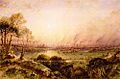
A view of Manchester from Kersal Moor, by William Wyld in 1852.
.jpg)
