
Lady Isle facts for kids
| Gaelic name | Eilean Mhoire |
|---|---|
| OS grid reference | NS27529335 |
| Coordinates | 55°32′N 4°44′W / 55.53°N 4.73°W |
| Physical geography | |
| Island group | Firth of Clyde |
| Area | 2.3 ha |
| Highest elevation | 6 m |
| Administration | |
| Sovereign state | United Kingdom |
| Country | Scotland |
| Council area | South Ayrshire |
| Demographics | |
| Population | 0 |
Lady Isle is a tiny, empty island in the Firth of Clyde, Scotland. Long ago, it had a small church dedicated to Saint Mary. Today, the island is home to a lighthouse and a natural freshwater spring.
Contents
Exploring Lady Isle's Geography
Lady Isle is about 2 miles (3.2 km) southwest of Troon. The island is around 0.6 kilometers long. Its highest point is only 6 meters above sea level. Smaller rocks like Half tide, Scart rocks, and Seal rock are close to Lady Isle. The island is part of the Dundonald area in South Ayrshire.
Lady Isle's Past: A Look at History
Old Maps and What They Show
Maps from long ago help us learn about Lady Isle. A map from 1604-1608 by Timothy Pont shows the island with its current name. It also shows a building, which was probably the old chapel.
Later maps, like one from 1686 by John Adair, called it Mary Isle. This map also clearly showed a chapel on the island. These old maps prove that Lady Isle has been known for a very long time.
Stories from Written Records
Historians believe Lady Isle might be the "Isle of Ayr" mentioned in old writings. In 1299, after a fire in Ayr, a nobleman from Ireland named Thomas Bysset took control of an island. He asked King Edward I of England to let him keep it forever, and the King agreed.
Old records also describe Lady Isle. They say it belongs to the Earl of Dundonald. These writings mention the ruins of an old chapel and a great freshwater spring. They also note that the island had many rabbits and lots of different seabirds and fish.
The island became the property of William Fullarton in 1698. Later, in 1805, the Marquess of Titchfield bought it. When he became the Duke of Portland, Lady Isle was part of his large Fullarton Estate.
Some people think the name "Lady" comes from the Scottish Gaelic word Laidh. This word means 'a ship's course'. This makes sense because Lady Isle has always been important for sailors. In the 1600s, the leaders of Glasgow built two stone pillars on the island. Sailors could line these up to find a safe place to anchor their ships during a storm.
In 1821, someone set fire to the island's grass. This fire destroyed the grazing land for animals. Strong winds then blew much of the island's soil into the sea. The island is still slowly recovering from this event.
Buildings and Features on Lady Isle
Saint Mary's Chapel: A Place of Worship
Lady Isle was once connected to an old church near Adamton called Lady Kirk. A chapel was built on the island and dedicated to the Virgin Mary. John Blair supported this chapel in 1446. Old maps show a religious building in the center of the island. The name Mary Isle also suggests the chapel was for Saint Mary. No signs of this old church remain today. It's likely that stones from the chapel were used to build later structures.
Beacons for Sailors
In the 1770s, the city of Glasgow put up two beacons on Lady Isle. These beacons helped ships find a safe place to anchor. This anchorage was to the east, or closer to shore. Ships that were too big for nearby harbors like Saltcoats, Irvine, or Ayr could anchor safely here.
One of these beacons was later replaced by the lighthouse. The other 18th-century beacon, when lined up with the lighthouse, still helped sailors find their way to a safe spot.
Lady Isle Lighthouse: A Guiding Light
 |
|
| Lady Isle Lighthouse in 2009 | |

Lady Isle Lighthouse
Location in Scotland
|
|
| Location | Lady Isle Troon Ayrshire Scotland United Kingdom |
|---|---|
| Coordinates | 55°31′38″N 4°44′02″W / 55.527180°N 4.733944°W |
| Year first constructed | 1903 |
| Construction | concrete tower |
| Tower shape | cylindrical tower with external spiral stairway |
| Markings / pattern | white tower and lantern, red vertical stripes |
| Height | 15 metres (49 ft) |
| Focal height | 19 metres (62 ft) |
| Range | 11 nautical miles (20 km; 13 mi) |
| Characteristic | Fl (4) W 30s |
| Admiralty number | A4562 |
| NGA number | 4744 |
| ARLHS number | SCO-117 |
Lady Isle has a unique lighthouse built in 1903. It's not a typical round tower. Instead, it's a platform on supports with an outside staircase. The light still helps ships navigate. It is managed by the Northern Lighthouse Board. Sailors need to be careful of rocks around the island, especially to the northeast.
Bird Observatory: A Home for Birds

Lady Isle is owned by the Marquess of Ailsa. For many years, it was a bird sanctuary. The Scottish Society for the Protection of Wild Birds (SSPWB) built and ran a bird observatory and a warden's post here.
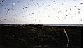
Different types of terns, like Common terns and Arctic terns, used to nest on the island. Roseate terns were also often seen. A sign on the observatory remembers Johnny Warren, an honorary warden who died in 1958. Lady Isle is believed to be Britain's first seabird reserve.
Freshwater Well: A Natural Spring
A freshwater well or spring is found in a rock basin in the middle of the island. This spring might be completely natural, or partly shaped by people. A freshwater supply would have been very important for the old chapel and for animals like sheep and rabbits that lived there.
Trig Point: Measuring the Island's Height
An Ordnance Survey trig point is on the island. It's a concrete pyramid that marks the island's 6-meter height. This trig point helps mapmakers measure distances and heights accurately.
Shipwrecks and Legends
Many shipwrecks are said to be around Lady Isle. One old story tells of a Spanish Armada ship that sank here. A local sorceress, Elcine de Aggart, supposedly used magic to cause the shipwreck. The ship was said to be carrying a golden throne for the King of Spain. People from Troon tried to find the treasure but never succeeded.
A Dutch diver was hired to find the wreck. He supposedly found the golden throne with a giant figure sitting on it. When he tried to grab the figure's hand, he found a cloven hoof instead! He escaped, and no one has tried to salvage the treasure since.
Lady Isle's Wildlife: Flora and Fauna


Lady Isle is home to many birds. Large numbers of gulls and eider ducks nest here. Shags and oystercatchers are often seen. A group of rabbits also lives on the island. Their burrows criss-cross the parts of the island with deeper soil.
Seals are often seen on the island and nearby rocks. One rock is even called Seal Rock. In the past, people tried to stop others from "poaching" the many lobsters found around the island.
Near the freshwater spring, you can find elder bushes. Sea pinks are also very common. As mentioned, a fire in the 1800s caused the island to lose much of its soil. Lady Isle is now a special "Area of Special Protection" for wildlife.
Scottish Wildlife Trust Visit
The Scottish Wildlife Trust once thought about making Lady Isle a nature reserve. However, the number of terns nesting there decreased, so the plan was not carried out. It's thought that fewer terns are breeding in the Clyde area because there are fewer places for them to feed and suitable habitats to nest.
Lady Isle Ship: A "Puffer" Boat
In the late 1950s, a cargo ship named 'Lady Isle' sailed in Scottish waters. This ship was a "VIC" boat, which stands for Victualling Inshore Craft. These were small steam-powered cargo boats, sometimes called "puffers." Many of these ships were built during World War II. The 'Lady Isle' was built in 1942 and later sold in 1949.
Troon Cruising Club Race
The Troon Cruising Club holds an annual Lady Isle race. This race helps raise money for the local RNLI (Royal National Lifeboat Institution) branch in Troon.
Images for kids
-
The island's vegetation; Ailsa Craig in the background.
-
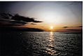
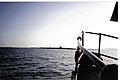
Sunset over the island looking towards the Isle of Arran. The Half tide rock is visible to the right hand side.
-
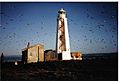
The 1903 lighthouse with Irvine in the background.
-
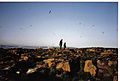
The bird observatory, lighthouse, Trig point and shed, with the 'beacon' in the background.
-
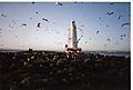
The island with the lighthouse and 'beacon' visible.
-
Looking over the island towards Irvine.
-
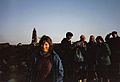
Members of the Scottish Wildlife Trust visiting Lady Isle in 1993.


See also
 In Spanish: Lady Isle para niños
