Lincoln County, Colorado facts for kids
Quick facts for kids
Lincoln County
|
|
|---|---|

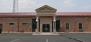
Lincoln County Courthouse in Hugo
|
|

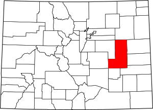
Location within the U.S. state of Colorado
|
|
 Colorado's location within the U.S. |
|
| Country | |
| State | |
| Founded | April 11, 1889 |
| Named for | Abraham Lincoln |
| Seat | Hugo |
| Largest town | Limon |
| Area | |
| • Total | 2,586 sq mi (6,700 km2) |
| • Land | 2,578 sq mi (6,680 km2) |
| • Water | 8.8 sq mi (23 km2) 0.3%% |
| Population
(2020)
|
|
| • Total | 5,675 |
| • Estimate
(2023)
|
5,480 |
| • Density | 2.1945/sq mi (0.84730/km2) |
| Time zone | UTC−7 (Mountain) |
| • Summer (DST) | UTC−6 (MDT) |
| Congressional district | 4th |
Lincoln County is a place in Colorado, a state in the United States. In 2020, about 5,675 people lived there. The main town, or county seat, is Hugo. Lincoln County was named after Abraham Lincoln, a famous U.S. President. It was created in 1889 from parts of Bent and Elbert counties.
Contents
Geography of Lincoln County
Lincoln County is quite large! It covers about 2,586 square miles. Most of this area is land, with only a small part being water.
Rivers and Creeks
The county has several important waterways. In the northern part, you'll find the Arikaree and Republican Rivers. In the southern part, there are creeks like Big Sandy, Rush, and Horse Creeks. Big Sandy and Rush Creeks eventually flow into the Arkansas River.
Neighboring Counties
Lincoln County shares borders with many other counties. These are like its neighbors:
- Washington County - to the north
- Kit Carson County - to the east
- Cheyenne County - to the east
- Crowley County - to the south
- Kiowa County - to the south
- Elbert County - to the west
- El Paso County - to the west
- Arapahoe County - to the northwest
- Pueblo County - to the southwest
Main Roads and Highways
Several major roads run through Lincoln County, making it easy to travel around:
 Interstate 70
 I-70 Bus.
 U.S. Highway 24
 U.S. Highway 40
 U.S. Highway 287
 State Highway 71
 State Highway 94
Population of Lincoln County
The number of people living in Lincoln County has changed over the years. Here's how the population has grown and shrunk:
| Historical population | |||
|---|---|---|---|
| Census | Pop. | %± | |
| 1890 | 689 | — | |
| 1900 | 926 | 34.4% | |
| 1910 | 5,917 | 539.0% | |
| 1920 | 8,273 | 39.8% | |
| 1930 | 7,850 | −5.1% | |
| 1940 | 5,882 | −25.1% | |
| 1950 | 5,909 | 0.5% | |
| 1960 | 5,310 | −10.1% | |
| 1970 | 4,836 | −8.9% | |
| 1980 | 4,663 | −3.6% | |
| 1990 | 4,529 | −2.9% | |
| 2000 | 6,087 | 34.4% | |
| 2010 | 5,467 | −10.2% | |
| 2020 | 5,675 | 3.8% | |
| 2023 (est.) | 5,480 | 0.2% | |
| U.S. Decennial Census 1790-1960 1900-1990 1990-2000 2010-2020 |
|||
In 2000, there were 6,087 people living in Lincoln County. These people lived in about 2,058 homes. Many of these homes, about 55%, were families with married couples. About 33% of homes had children under 18 living there.
The average age of people in the county in 2000 was 38 years old. About 24% of the population was under 18 years old.
Towns and Communities
Lincoln County has several towns and smaller communities where people live.
Towns
Unincorporated Communities
These are smaller places that don't have their own local government like towns do:
The Historic Smoky Hill Trail
A very old path called the Smoky Hill Trail passes through Lincoln County. This trail was used by travelers heading west a long time ago.
Why "Smoky Hill"?
The trail got its name because of how the hills looked. As travelers moved west from places like Kansas and Nebraska, they saw misty or smoky-looking hills. This was especially true for those heading to the Colorado Gold Rush that started in 1858. Gold had been found near Denver, and many people wanted to find their fortune.
The "Starvation Trail"
A part of the Smoky Hill Trail is sometimes called the "starvation trail." This was the hardest part of the journey because there wasn't much water. Even though it was tough for travelers, the Plains Indians who lived there thought it was a great place to hunt. You can still see parts of this old trail today as a two-track road on the flat lands of eastern Colorado.
See also
 In Spanish: Condado de Lincoln (Colorado) para niños
 | Delilah Pierce |
 | Gordon Parks |
 | Augusta Savage |
 | Charles Ethan Porter |

