Lincoln County, Wisconsin facts for kids
Quick facts for kids
Lincoln County
|
|
|---|---|

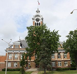
Lincoln County Courthouse
|
|

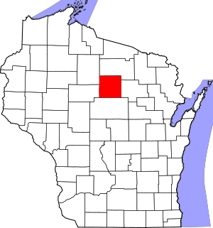
Location within the U.S. state of Wisconsin
|
|
 Wisconsin's location within the U.S. |
|
| Country | |
| State | |
| Founded | 1875 |
| Named for | Abraham Lincoln |
| Seat | Merrill |
| Largest city | Merrill |
| Area | |
| • Total | 907 sq mi (2,350 km2) |
| • Land | 879 sq mi (2,280 km2) |
| • Water | 28 sq mi (70 km2) 3.1%% |
| Population
(2020)
|
|
| • Total | 28,415 |
| • Estimate
(2023)
|
28,405 |
| • Density | 31.329/sq mi (12.096/km2) |
| Time zone | UTC−6 (Central) |
| • Summer (DST) | UTC−5 (CDT) |
| Congressional district | 7th |
Lincoln County is a special area called a county in the state of Wisconsin, USA. It was created in 1875. The county is named after a very famous American president, Abraham Lincoln.
In 2020, about 28,415 people lived in Lincoln County. The main town, or "county seat," where the government offices are, is Merrill.
Contents
Exploring Lincoln County's Location
Lincoln County covers a total area of about 907 square miles. Most of this area, about 879 square miles, is land. The rest, about 28 square miles, is water, like lakes and rivers.
Nearby Counties
Lincoln County shares its borders with several other counties:
- Oneida County is to the north.
- Langlade County is to the east.
- Marathon County is to the south.
- Taylor County is to the west.
- Price County is to the northwest.
Main Roads and Travel
You can get around Lincoln County using several important roads. These are like the main arteries for cars and trucks:
 U.S. Highway 8
 U.S. Highway 51
 Highway 17 (Wisconsin)
 Highway 64 (Wisconsin)
 Highway 86 (Wisconsin)
 Highway 107 (Wisconsin)
Railways and Airports
Trains also travel through Lincoln County on these railway lines:
- Tomahawk Railway
- Watco
If you want to fly, there are two airports in the county:
- KRRL - Merrill Municipal Airport
- KTKV - Tomahawk Regional Airport
Who Lives in Lincoln County?
| Historical population | |||
|---|---|---|---|
| Census | Pop. | %± | |
| 1880 | 2,011 | — | |
| 1890 | 12,008 | 497.1% | |
| 1900 | 16,269 | 35.5% | |
| 1910 | 19,064 | 17.2% | |
| 1920 | 21,084 | 10.6% | |
| 1930 | 21,072 | −0.1% | |
| 1940 | 22,536 | 6.9% | |
| 1950 | 22,235 | −1.3% | |
| 1960 | 22,338 | 0.5% | |
| 1970 | 23,499 | 5.2% | |
| 1980 | 26,555 | 13.0% | |
| 1990 | 26,993 | 1.6% | |
| 2000 | 29,641 | 9.8% | |
| 2010 | 28,743 | −3.0% | |
| 2020 | 28,415 | −1.1% | |
| 2023 (est.) | 28,405 | −1.2% | |
| U.S. Decennial Census 1790–1960 1900–1990 1990–2000 2010 2020 |
|||
In 2020, the population density was about 32 people for every square mile. There were also many homes, about 16,034 housing units.
Most people living in Lincoln County are White (about 94.7%). Smaller groups include Black or African American people (0.6%), Native American people (0.4%), and Asian people (0.4%). Some people are from other backgrounds or a mix of two or more races. About 1.9% of the population is Hispanic or Latino.
Towns and Communities
Lincoln County has several cities, towns, and smaller communities where people live.
Cities
Towns (Smaller Government Areas)
Unincorporated Communities (Smaller Villages or Areas)
- Bloomville
- Bradley
- Bundy
- Clifford (partial)
- Doering
- Dudley
- Dutch Corners
- Gilbert
- Gleason
- Harrison
- Heafford Junction
- Irma
- Jeffris
- McCord (partial)
- Otis
- Pine River
- Spirit Falls
- Tripoli (partial)
- West Kraft
See also
 In Spanish: Condado de Lincoln (Wisconsin) para niños
 | Victor J. Glover |
 | Yvonne Cagle |
 | Jeanette Epps |
 | Bernard A. Harris Jr. |

