
List of districts of Kerala facts for kids
Quick facts for kids Districts of Kerala |
|
|---|---|

Districts of Kerala
|
|
| Category | Districts |
| Location | Kerala |
| Number | 14 districts |
| Populations | Wayanad – 846,637 (lowest); Malappuram – 4,494,998 (highest) |
| Areas | Alappuzha – 1,415 km2 (546 sq mi) (smallest); Idukki – 4,612 km2 (1,781 sq mi) (largest) |
| Government | Government of Kerala |
| Subdivisions | Revenue Divisions of Kerala |
The Indian state of Kerala is divided into 14 districts. Think of districts as big sections of a state. They help the government manage things better. These districts are then split into smaller parts called revenue divisions and taluks.
Idukki is the largest district in Kerala. It covers a huge area of 4,612 square kilometers.
When India became independent, smaller states joined together. On July 1, 1949, the states of Travancore and Cochin formed Travancore-Cochin. However, parts of Malabar stayed with the Madras state. On November 1, 1956, Kerala became a full state. This happened when all the Malayalam-speaking areas in the southwest of India came together.
Kerala has three main regions:
- Northern Kerala includes Kasaragod, Kannur, Wayanad, Kozhikode, and Malappuram.
- Central Kerala has Palakkad, Thrissur, Ernakulam, Idukki, and Kottayam.
- Southern Kerala includes Alappuzha, Pathanamthitta, Kollam, and Thiruvananthapuram.
These regions were once historical kingdoms like Cochin and Travancore. Most districts are named after their biggest town or city. In 1990, some districts got their local names back instead of English ones.
For local management, Kerala has different types of councils. There are 6 city corporations and 87 municipalities for towns. For rural areas, there are 941 village councils (Gram Panchayats), 152 block councils (Block Panchayats), and 14 district councils (District Panchayats).
Contents
How Districts are Managed

Kerala is divided into 14 districts. These districts are further split into 27 revenue divisions, 78 taluks, 152 community development blocks, and 1664 revenue villages.
Each district is led by a District Collector. This person is a high-ranking officer from the Indian Administrative Service (IAS). The State Government of Kerala appoints them. The main office for district management is called the Collectorate.
The District Collector is in charge of collecting taxes and keeping law and order. They work for the state government and also represent the people. Different government departments have offices in each district. Their officers give advice to the Collector.
For local self-governance, there are 941 Gram Panchayats (for villages), 6 corporations (for big cities), and 87 municipalities (for towns).
Taluks and community development blocks are other ways to divide the district. Community development blocks help with rural development. Each block includes several Gram Panchayats.
A taluk includes towns and villages. The Tahsildar is in charge of each taluk. They collect revenue and stay in touch with people in every village. Village officers help the Tahsildar.
A Block Development Officer (BDO) manages each block. The Government of Kerala appoints them. A Gram Panchayat is a group of villages led by a President. A municipality is an urban area led by a Chairperson. In big cities, a municipal corporation is led by a Mayor.
The Superintendent of Police (SP) leads the police in each district. They are part of the Indian Police Service. Districts are further divided into police sub-divisions. These are led by an Assistant or Deputy Superintendent of Police. Below them are police stations, led by an Inspector or Sub-Inspector.
The Kerala High Court is the main court for Kerala. Each district also has its own District & Sessions Court.
History of Districts
When Kerala state was first formed, it had only five districts: Malabar, Thrissur, Kottayam, Kollam, and Thiruvananthapuram.
Here’s how the other districts were added:
- January 1, 1957: The Malabar district was split into three new districts: Kannur, Kozhikode, and Palakkad. This made a total of seven districts.
- August 17, 1957: Alappuzha district was created from parts of Kottayam and Kollam districts. It became the 8th district.
- April 1, 1958: Ernakulam district was formed as the 9th district. It was made from parts of Thrissur and Kottayam districts.
- June 16, 1969: Malappuram district became the 10th district. It was formed from parts of Kozhikode and Palakkad districts.
- January 26, 1972: Idukki district was formed as the 11th district. It took areas from Kottayam and Ernakulam districts.
- November 1, 1980: Wayanad district became the 12th district. It was created from areas in Kozhikode and Kannur districts.
- November 1, 1982: Pathanamthitta district was formed as the 13th district. It took parts from Kollam, Alappuzha, and Idukki districts.
- May 24, 1984: Kasaragod district was formed as the 14th district. It was carved out of a large part of the Kannur district.
District Facts
Idukki district is the largest district in Kerala by area. This happened after some land was moved from Ernakulam district to Idukki district. Alappuzha district is known for being the smallest in area.
Malappuram district has the most people in Kerala. On the other hand, Wayanad, Idukki, and Kasargod have the fewest people.
Ernakulam district is the most urbanized district. This means many people there live in cities and towns. About 68% of its population lives in urban areas. Thiruvananthapuram has the highest population density, with 1509 people living in each square kilometer. Alappuzha and Kozhikode districts also have high population densities.
Alphabetical Listing
| Code | District | Headquarters | Established | Population (2018) | Area | Subdivisions | Location |
|---|---|---|---|---|---|---|---|
| ALA | Alappuzha | Alappuzha | 17 Aug 1957 | 2,146,033 | 1,415 km2 (546 sq mi) |
|
|
| ERN | Ernakulam | Kakkanad | 1 Apr 1958 | 3,427,659 | 2,924 km2 (1,129 sq mi) | ||
| IDU | Idukki | Painavu | 26 Jan 1972 | 1,093,156 | 4,612 km2 (1,781 sq mi) |
|
|
| KAN | Kannur | Kannur | 1 Jan 1957 | 2,615,266 | 2,966 km2 (1,145 sq mi) | ||
| KAS | Kasaragod | Kasaragod | 24 May 1984 | 1,390,894 | 1,989 km2 (768 sq mi) |
|
|
| KOL | Kollam | Kollam | 1 Nov 1956 ( 1 July 1949) |
2,659,431 | 2,483 km2 (959 sq mi) |
|
|
| KOT | Kottayam | Kottayam | 1 Nov 1956 (1 July 1949 ) |
1,983,573 | 2,206 km2 (852 sq mi) |
|
|
| KOZ | Kozhikode | Kozhikode | 1 Jan 1957 | 3,249,761 | 2,345 km2 (905 sq mi) |
|
|
| MAL | Malappuram | Malappuram | 16 Jun 1969 | 4,494,998 | 3,554 km2 (1,372 sq mi) |
|
|
| PAL | Palakkad | Palakkad | 1 Jan 1957 | 2,952,254 | 4,482 km2 (1,731 sq mi) | ||
| PAT | Pathanamthitta | Pathanamthitta | 1 Nov 1982 | 1,172,212 | 2,652 km2 (1,024 sq mi) |
|
|
| THI | Thiruvananthapuram | Thiruvananthapuram | 1 Nov 1956 (1 July 1949) |
3,355,148 | 2,189 km2 (845 sq mi) |
|
|
| THR | Thrissur | Thrissur | 1 Nov 1956 (1 Jul 1949) |
3,243,170 | 3,027 km2 (1,169 sq mi) |
|
|
| WAY | Wayanad | Kalpetta | 1 Nov 1980 | 846,637 | 2,130 km2 (820 sq mi) |
|
|
| Total | 14 | 14 | 14 | 34,630,192 | 38,852 km2 (15,001 sq mi) | 78 |
Images for kids
-
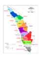
Map of Kerala showing its districts.
See also
 In Spanish: Anexo:Distritos del estado de Kerala para niños
- Kerala state
- Government of Kerala
- Revenue Department (Kerala)
- List of revenue divisions of Kerala
- List of taluks of Kerala
