
Kasaragod facts for kids
Quick facts for kids
Kasaragod
|
|
|---|---|
|
Municipal Town
|
|
| Kasaragod | |
  Clockwise from top:
Bekal beach, Chandragiri River, Chandragiri Fort, Ranipuram, Bekal Fort, Kavvayi Backwaters at Nileshwaram, Malik Dinar Mosque, and Arikady fort |
|
| Nickname(s):
The Land of Seven Languages, The Land of God
|
|

Kasaragod
Location in Kerala

Kasaragod
Location in India
|
|
| Country | |
| State | Kerala |
| District | Kasaragod |
| Municipality Established | 1966 |
| Government | |
| • Type | District |
| • Body | Kasaragod Municipality |
| Area | |
| • Municipal Town | 16.7 km2 (6.4 sq mi) |
| • Metro | 93.3 km2 (36.0 sq mi) |
| Elevation | 19 m (62 ft) |
| Population | |
| • Municipal Town | 54,172 |
| • Density | 3,244/km2 (8,401/sq mi) |
| • Metro | 192,856 |
| Languages | |
| • Official | Malayalam, Kannada, English |
| Time zone | UTC+5:30 (IST) |
| PIN |
671121
|
| Telephone | +91 4994 |
| Vehicle registration | KL-14 |
Kasaragod is a town in the state of Kerala, India. It is the main administrative center of the Kasaragod district. The town was established as a municipality in 1966. Kasaragod is the northernmost district in Kerala. It is often called Sapta Bhasha Sangama Bhumi, which means 'The Land of Seven Languages'.
This area is rich in biodiversity because it is part of the Western Ghats. Kasaragod is famous for its historic forts like Chandragiri and Bekal Fort. It also has the Chandragiri River and beautiful natural spots like Ranipuram and Kottancheri Hills. You can find old temples like Madiyan Kulom temple and Ananthapura Lake Temple, as well as the Malik Deenar Mosque here. The historic hill of Ezhimala is located near the Kavvayi Backwaters of Nileshwaram.
Kasaragod is about 90 kilometers (56 miles) north of Kannur city. It is also 50 kilometers (31 miles) south of Mangalore. Kasaragod district has the most rivers in Kerala, with 12 rivers flowing through it. The town is located where the Chandragiri River, the longest river in the district, meets the Arabian Sea. Many forts are found in Kasaragod, including Arikady fort, Bekal Fort, Chandragiri Fort, and Hosdurg Fort. Bekal Fort is the biggest fort in all of Kerala. Talakaveri, where the 805-kilometer (500-mile) long Kaveri river begins, is close to Ranipuram on the border between Kerala and Karnataka.
In the 19th century, a scholar named Robert Caldwell noted that the Malayalam language was spoken from the Chandragiri area in the north to the Neyyar river in the south. It also stretched from the Malabar Coast in the west to the Western Ghats in the east. This included the islands of Lakshadweep in the Arabian Sea.
Contents
Understanding the Name Kasaragod
There are different ideas about where the name Kasaragod comes from. However, none of them are fully proven.
In Malayalam, Kasaragod was known as Kāññirakkōṭŭ. This name means 'The land of kāññiram trees'. Kāññiram is the Malayalam word for Kasaraka trees, which are found in large numbers here.
Until the 16th century, Kasaragod was part of the Kumbla dynasty. This dynasty was under the rule of the Kolathunadu kingdom, which was based in Kannur. Later, in the 16th century CE, Kannada kingdoms focused on the port and surrounding areas.
A Look at Kasaragod's Past
Early History of Kasaragod

Ancient Tamil writings from the Sangam Age show that this area was once part of Puzhinadu. This region included the coastal land from Kozhikode to Mangalore. Politically, it was part of the Ezhimala Kingdom. The capital of this kingdom was at Ezhimala in today's Kannur district. King Nannan was the most famous ruler of Ezhimala. His kingdom reached up to Gudalur and parts of Coimbatore.
The Mooshaka kings were believed to be descendants of Nannan. By the 14th century, the Mooshaka Kingdom became known as Kolathirinad. Its rulers were called Kolathiris. At its strongest, the Kolathunad Kingdom stretched from the Netravati River in the north to Korapuzha in the south. It had the Arabian Sea to the west and the Kodagu hills to the east. It also included the islands of Lakshadweep.
Kasaragod in Medieval Times


Kasaragod was an important trading center a long time ago. It is about 50 kilometers (31 miles) south of Mangalore city. The ancient Malayalam literary work, Ramacharitam, was likely written in the Kasaragod district. This is because its old copies were found in Nileshwaram. The poem also talks about the Ananthapura Lake Temple in Kumbla.
Arab travelers knew Kasaragod as Harkwillia. The Malik Dinar Mosque in Kasaragod town is one of the oldest mosques in India. It is believed that Malik Dinar died in Thalangara, Kasaragod. Many Arab travelers visited Kasaragod between the 9th and 14th centuries. This shows how important it was for trade back then. A Portuguese traveler, Duarte Barbosa, visited Kumbla in 1514. He wrote that rice was traded for coir (coconut fiber) with the Maldives.
Until the 16th century CE, Kasaragod town was called Kanhirakode. This name likely meant 'the land of Kanhira trees'. The Kumbla dynasty ruled the land between the Chandragiri River and Netravati River. This area included today's Manjeshwar and Kasaragod regions. They were also under the Kolathunadu kingdom of North Malabar. This was before the Carnatic conquests by the Vijayanagara Empire.
The Kolathiri kingdom later split into ten smaller independent areas. This happened because of disagreements within the royal family. Many parts of today's Hosdurg taluk and Vellarikundu were part of the Nileshwaram dynasty. This dynasty was related to both Kolathunadu and the Zamorin of Calicut. The areas north of the Chandragiri river were ruled by the Kumbala dynasty.
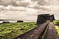
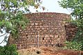
The Chandragiri Fort stands on the southern bank of the Chandragiri River estuary. It is right across from Kasaragod town. The Bekal Fort at Bekal, Pallikkara, was built in 1650 by Shivappa Nayaka of Keladi. It is the largest fort in Kerala.

Kasaragod During Colonial Times


Francis Buchanan, a doctor for Arthur Wellesley, visited Kasaragod in 1800. In his travel diary, he wrote about places like Athiraparambu, Kavvayi, Nileshwaram, Bekal, Chandragiri and Manjeshwar.
The areas of Hosdurg and Vellarikundu were part of Kolathunadu. This was south of the Chandragiri river. Kasaragod and Manjeshwaram were in the Tulu Nadu region, north of the Chandragiri river.
In 1763, Hyder Ali attacked Bedanoor, the capital of the Ikkery Naiks. His son, Tippu Sultan, later attacked much of the Malabar region in Kerala. By the Treaty of Seringapatam in 1792, Tippu gave Malabar to the British. The British took over Kanara after Tippu Sultan died. Initially, South Canara was part of the Bombay presidency. Later, on April 16, 1862, South Canara was moved to Madras Presidency. The Kasaragod taluk was then formed, replacing the old Bekal taluk. Kasaragod was the second most populated and second largest taluk in South Canara.
Kasaragod After India's Independence

Before Kerala state was formed, Kasaragod was part of the South Canara district of the Madras Presidency. In the 19th century, many people in Kasaragod wanted the region to join the Malabar District. This was because it was the only area in South Canara where most people spoke Malayalam.
Kasaragod became part of the Kannur district of Kerala on November 1, 1956. This happened when states were reorganized in India. Later, Kasaragod was split into two smaller areas, Kasaragod and Hosdurg, to make administration easier. Kasaragod was officially made a district in 1984.
Joining Kasaragod with Kerala has been a debated topic. This is because a large number of people there speak Tulu and Kannada. In 1951, about 72% of the district's population spoke Malayalam. About 14.2% spoke Tulu and 6.3% spoke Kannada. However, by 2011, only 8.8% spoke Tulu and 4.2% spoke Kannada.
In 2012, the government set up a special committee. This committee was led by P. Prabhakaran. Its job was to study the problems faced by Kasaragod, being the northernmost district. They were also asked to create a special plan to help the district. In 2013, two more areas, Manjeshwaram and Vellarikundu, became new taluks in the district. Before this, the district only had two taluks.
Kasaragod's Location and Weather
Climate
Kasaragod has a tropical monsoon climate. This means it has hot, humid summers and mild winters, with a lot of rain. It receives a lot of rain every year, about 3,825 millimeters (150 inches).
| Climate data for Kasaragod, Kerala | |||||||||||||
|---|---|---|---|---|---|---|---|---|---|---|---|---|---|
| Month | Jan | Feb | Mar | Apr | May | Jun | Jul | Aug | Sep | Oct | Nov | Dec | Year |
| Mean daily maximum °C (°F) | 31.4 (88.5) |
31.5 (88.7) |
32.2 (90.0) |
32.7 (90.9) |
32.2 (90.0) |
29.3 (84.7) |
28.2 (82.8) |
28.4 (83.1) |
28.8 (83.8) |
30.0 (86.0) |
31.0 (87.8) |
31.5 (88.7) |
30.6 (87.1) |
| Mean daily minimum °C (°F) | 21.7 (71.1) |
22.8 (73.0) |
24.3 (75.7) |
25.9 (78.6) |
25.7 (78.3) |
23.9 (75.0) |
23.4 (74.1) |
23.6 (74.5) |
23.5 (74.3) |
23.8 (74.8) |
23.1 (73.6) |
22.0 (71.6) |
23.6 (74.6) |
| Average precipitation mm (inches) | 1 (0.0) |
1 (0.0) |
5 (0.2) |
55 (2.2) |
262 (10.3) |
1,002 (39.4) |
1,190 (46.9) |
647 (25.5) |
338 (13.3) |
229 (9.0) |
77 (3.0) |
18 (0.7) |
3,825 (150.5) |
| Source: Climate-Data.org | |||||||||||||
Rivers of Kasaragod
Kasaragod district has the most rivers in Kerala, with 12 rivers. All these rivers flow towards the west. The longest river is the Chandragiri River, which is 105 kilometers (65 miles) long. The town of Kasaragod is located where the Chandragiri river meets the sea. It flows into the Arabian Sea at Thalangara. The Chandragiri Fort is built on its bank. This river starts in Pattimala in Kodagu (Coorg). The smallest river in Kerala is also in this district.
| River | Origin | Length (km) | ||
| Total | Navigable | |||
| 1 | Manjeshwar River | Kadandur hills | 16 | 3 |
|---|---|---|---|---|
| 2 | Uppala River | Kudipadi hills, Veerakamba | 50 | N/A |
| 3 | Shiriya River | Kanakad hills, Anegundi Reserve Forest | 61 | 5 |
| 4 | Kumbla River | Yedanad | 11 | 3 |
| 5 | Mogral River | Kanlur, Karadka Reserve Forest | 34 | N/A |
| 6 | Chandragiri River | Patti forest, Talakaveri Wildlife Sanctuary | 105 | 13 |
| 7 | Kalnad River | Chettianchal | 8 | N/A |
| 8 | Bekal River | Kaniyadka | 11 | N/A |
| 9 | Chittari River | Kundiya | 25 | N/A |
| 10 | Neeleshwaram River (Thejaswini River) |
Kinanoor, Talakaveri Wildlife Sanctuary | 47 | 11 |
| 11 | Kariangode River | Padinalkad, Coorg hills | 64 | 24 |
| 12 | Kavvayi River | Cheemeni | 23 | 10 |
Education and Research in Kasaragod


Kasaragod district is under the Kannur University. Kasaragod is home to the Central Plantation Crops Research Institute (CPCRI). This institute was first set up in 1916 as the Coconut Research Station. It is part of India's National Agricultural Research System. The Central University of Kerala is also located in Kasaragod, in the Periya hills.
Here are some important educational and research centers:
- The Central Plantation Crops Research Institute in Kasaragod started in 1916.
- Government College Kasaragod was established in 1957.
- The Central University of Kerala was established in 2009.
- Malik Deenar Institute of Management Studies is in Seethamgoly, Kasaragod.
- Lal Bahadur Shastry College of Engineering, Kasaragod, was established in 1993.
- College of Engineering Trikaripur was established in 2000.
Getting Around Kasaragod
.jpg)
The National Highway 66 runs along the western coast of India. It connects Mumbai to Kanyakumari and passes through Kasaragod district. This highway links major coastal towns like Manjeshwar, Uppala, Kumbla, Kasaragod, Udma, Bekal, Kanhangad, Nileshwaram, and Thrikaripur.
The Kerala State Road Transport Corporation (KSRTC) has bus stations in the district. The railway line also runs along the coast. The Kasaragod railway station is on the Mangalore-Shoranur line. Kasaragod district has three of Kerala's 13 smaller ports: Manjeshwar, Kasaragod, and Nileshwaram. The closest international airports are in Mangalore (65 km away) and Kannur (110 km away).
People and Languages in Kasaragod
Religions in Kasaragod Town (2011) Islam (54.65%) Hinduism (43.56%) Christianity (1.58%) Other (0.22%)
According to the 2011 Census, Kasaragod municipality had a population of 54,172 people. This included 26,319 males and 27,853 females. The municipality covers an area of 16.69 square kilometers (6.44 sq mi) and has 10,202 families living there. The municipality is divided into 35 wards, and elections are held every 5 years.
The female-to-male ratio was 1058 females for every 1000 males. This was lower than the state average of 1084. About 13.4% of the population (7,234 people) were aged 0-6 years. The literacy rate in Kasaragod town was 94.76%, which is higher than the state average of 94%. For males, literacy was 96.5%, and for females, it was 93.1%.
| Languages in Kasaragod taluk | ||||
|---|---|---|---|---|
| Language | Speakers | |||
| Malayalam | 70.5% | |||
| Tulu | 16.2% | |||
| Kannada | 6.4% | |||
| Marathi | 2.7% | |||
| Konkani | 2.3% | |||
| Others | 1.9% | |||
| Distribution of languages Source: 2011 Census |
||||
Helping Kasaragod Grow
.jpg)
Kasaragod district is the northernmost district of Kerala. It is quite far from Thiruvananthapuram, the state capital, which is at the southern tip of Kerala. For example, Manjeshwaram town is about 600 kilometers (370 miles) north of Thiruvananthapuram. It is also about 30 kilometers (19 miles) south of Mangalore and 350 kilometers (220 miles) west of Bangalore.
Because of its distance from the state capital, the district faced some challenges. In 2012, the government set up a special committee. This committee was led by former Chief Secretary P. Prabhakaran. Its job was to study the problems faced by Kasaragod and suggest a special plan to help the district. In 2013, two new areas, Manjeshwaram and Vellarikundu, were formed as taluks. Before this, the district only had two taluks. The government also decided to build a gas-based power plant in Cheemeni. A government medical college was also approved for Kasaragod district in 2013. This was part of a plan to have at least one government medical college in all 14 districts of Kerala.
Fun Places to Visit in Kasaragod


Kasaragod has many interesting places to visit:
- Ananthapuram Lake Temple
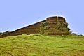
- Arikady fort
- Bekal Fort
- Chandragiri Fort
- Edayilakkad Island
- Kanwatheertha beach
- Kappil beach
- Kottanchery hills
- Malik Dinar Mosque
- Mayipady palace
- Nileshwaram Estuary beach
- Our Lady of Sorrows Church
- Pallikkara beach
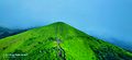
- Ranipuram Hill Station
- Valiyaparamba Island
Famous People from Kasaragod


Many notable people have come from Kasaragod, including:
- Ambikasuthan Mangad – A Malayalam writer.
- Anil Kumble – A former Indian cricketer and coach.
- Arya – An Indian actor.
- K. K. Venugopal – A former Attorney General of India.
- Kavya Madhavan – An Indian actress.
- Kayyar Kinhanna Rai – An Indian Independence activist.
- Mahima Nambiar – An Indian actress.
- P. Kunhiraman Nair – A Malayalam poet.
- Roopesh Shetty – An actor and radio jockey.
- Sara Aboobacker – A Kannada writer.
- Vysakh – A Malayalam film director.
Images for kids
-
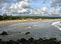
Bekal beach
-
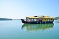
Kavvayi Backwaters at Nileshwaram
-
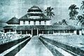
Malik Dinar Mosque
-
Chandragiri River
-
Bekal Fort
-
Arikady fort
-
Chandragiri Fort
-
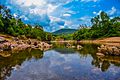
Ranipuram


See also
 In Spanish: Kasaragod para niños
