
List of waterfalls in Hamilton, Ontario facts for kids

The city of Hamilton in Ontario, Canada is famous for its more than 100 waterfalls! Most of these waterfalls are found along or near the Bruce Trail, which follows the Niagara Escarpment. The Niagara Escarpment is a long cliff that stretches across Ontario, and its unique rock layers create the perfect conditions for waterfalls to form. You can find waterfalls along this escarpment all the way from Tobermory to Niagara Falls.
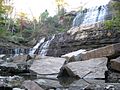
Hamilton is home to some impressive waterfalls. Webster's Falls is the widest waterfall in the city, with a crest (the top edge where the water flows over) of about 30 metres (100 feet). Tew's Falls is the tallest, dropping about 41 metres (135 feet) like a thin ribbon of water. Both Webster's and Tew's Falls are located in the Spencer Gorge / Webster's Falls Conservation Area, which is a great place to visit. Did you know that Albion Falls was once considered as a way to supply water to Hamilton? Also, rocks from the Albion Falls area were used to build the Rock Garden at the Royal Botanical Gardens!
Sadly, Hamilton used to have even more waterfalls. Many in the central part of the city disappeared as more people moved in and new buildings were constructed on Hamilton Mountain. In the past, parts of the city were built on land that was once wet or marshy. This changed how water drained and affected the natural water systems, including some waterfalls.
Contents
Exploring Hamilton's Waterfalls
Many waterfalls in west Hamilton can be reached from the Chedoke Radial Trail. This trail follows an old railway line that used to carry electric trains between Brantford and Hamilton. Back in 1898, a group of five men known as "The Five Johns" brought electric power to Hamilton. They sent electricity 27 miles from DeCew Falls near St. Catharines, using water from the old Welland Canal. This cheaper and more efficient power attracted new industries, like the companies that later became Stelco (a steel company) and Canadian Westinghouse (an electrical company). Because of this, Hamilton was once nicknamed "The Electric City"!

Types of Waterfalls
Waterfalls come in different shapes and sizes! Here are four main types you might see in Hamilton:
- Ribbon: These waterfalls are very tall but not very wide, so the water looks like a thin ribbon.
- Classical: For these waterfalls, the height and width are about the same.
- Curtain: These waterfalls are much wider than they are tall, creating a wide sheet of water like a curtain.
- Cascade: Instead of one big drop, the water in a cascade flows down a series of steps or gentle slopes.
What Makes a Hamilton Waterfall?
To be officially counted as a Hamilton waterfall, it needs to meet a few rules:
- It must have a vertical drop of at least 3 metres (10 feet) or be a cascade.
- The top edge (crest) where the water flows over must be at least 1 metre (3 feet) wide.
- It needs to be mostly natural, not completely man-made.
- If two waterfalls are next to each other but come from different creeks or streams, they can be counted as separate waterfalls.
- The waterfall must be located within the boundaries of the new City of Hamilton.
On January 1, 2001, the new City of Hamilton was formed. This happened when the original city of Hamilton joined with five nearby towns: Ancaster, Dundas, Flamborough, Glanbrook, and Stoney Creek. Before this, Hamilton had about 331,121 people. After joining together, the new city had about 490,268 people living in over 200 neighbourhoods!
Waterfalls list
The Hamilton Conservation Authority maintains a web database of the city's waterfalls. The list below comes from that website, which contains 100 waterfalls.
| Photo | Name | Height | Width | Coordinates |
|---|---|---|---|---|
 |
Albion Falls | 62.32 feet (19.00 m) | 59.04 feet (18.00 m) | 43°12′01″N 79°49′11″W / 43.2004°N 79.8196°W |
 |
Ancaster Heights Falls | 43.952 feet (13.397 m) | 5.904 feet (1.800 m) | 43°14′23″N 79°57′46″W / 43.2397°N 79.9628°W |
|
Auchmar Falls | 40 feet (12 m) | 5 feet (1.5 m) | 43°14′37″N 79°53′28″W / 43.2436°N 79.8912°W |
|
Baby Albion Falls | 28 feet (8.5 m) | 3 feet (0.91 m) | 43°12′00″N 79°49′11″W / 43.2001°N 79.8196°W |
 |
Baby Webster Falls | 29.52 feet (9.00 m) | 9.84 feet (3.00 m) | 43°16′33″N 79°58′55″W / 43.2757°N 79.9819°W |
|
Beckett Falls | 10 feet (3.0 m) | 4 feet (1.2 m) | 43°14′42″N 79°53′09″W / 43.2449°N 79.8858°W |
|
Billy Green Falls | 55.76 feet (17.00 m) | 19.68 feet (6.00 m) | 43°12′26″N 79°45′59″W / 43.2072°N 79.7664°W |
.jpg) |
Billy Monkley Cascade | 10 feet (3.0 m) | 21 feet (6.4 m) | 43°11′25″N 79°49′49″W / 43.1904°N 79.8304°W |
|
Blue Falls | 13 feet (4.0 m) | 10 feet (3.0 m) | |
 |
Borer's Falls | 49.2 feet (15.0 m) | 16.4 feet (5.0 m) | 43°17′38″N 79°56′12″W / 43.2938°N 79.9368°W |
|
Broman Falls | 22 feet (6.7 m) | 3 feet (0.91 m) | 43°12′51″N 79°48′58″W / 43.2142°N 79.816°W |
 |
Buttermilk Falls | 75.44 feet (22.99 m) | 26.24 feet (8.00 m) | 43°12′19″N 79°49′11″W / 43.2053°N 79.8196°W |
|
Canterbury Falls | 29.52 feet (9.00 m) | 13.12 feet (4.00 m) | 43°14′13″N 79°58′51″W / 43.237°N 79.9807°W |
|
Cave Falls | 50 feet (15 m) | 10 feet (3.0 m) | |
|
Centennial Falls | 32.8 feet (10.0 m) | 13.12 feet (4.00 m) | 43°12′31″N 79°46′07″W / 43.2086°N 79.7685°W |
.jpg) |
Chedoke Falls | 59.04 feet (18.00 m) | 29.52 feet (9.00 m) | |
|
Clappison Falls | 23 feet (7.0 m) | 10 feet (3.0 m) | |
|
Cliffview Falls | 49.2 feet (15.0 m) | 9.84 feet (3.00 m) | 43°14′39″N 79°54′28″W / 43.2443°N 79.9079°W |
.jpg) |
Darnley Cascade | 13.12 feet (4.00 m) | 72.16 feet (21.99 m) | 43°16′38″N 80°00′24″W / 43.2772°N 80.0068°W |
 |
Denlow Falls | 62.32 feet (19.00 m) | 29.52 feet (9.00 m) | |
.jpg) |
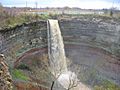
Devil's Punch Bowl Falls | 121.36 feet (36.99 m) | 9.84 feet (3.00 m) | 43°12′37″N 79°45′21″W / 43.2103°N 79.7559°W |
|
Dewitt Falls | 22.96 feet (7.00 m) | 6.56 feet (2.00 m) | 43°12′24″N 79°43′06″W / 43.2068°N 79.7184°W |
|
Duchess Falls | 13 feet (4.0 m) | 5 feet (1.5 m) | |
|
Dundas Falls | 20.992 feet (6.398 m) | 21.976 feet (6.698 m) | 43°16′23″N 79°58′20″W / 43.273°N 79.9722°W |
|
Dyment Falls | 51.496 feet (15.696 m) | 13.12 feet (4.00 m) | 43°16′42″N 79°56′57″W / 43.2782°N 79.9491°W |
|
East Glover's Falls | 19.68 feet (6.00 m) | 9.84 feet (3.00 m) | |
|
East Greensville Falls | 18.04 feet (5.50 m) | 4.92 feet (1.50 m) | 43°16′46″N 79°59′29″W / 43.2794°N 79.9915°W |
|
East Iroquoia Falls | 65.6 feet (20.0 m) | 3.936 feet (1.200 m) | 43°14′41″N 79°56′19″W / 43.2448°N 79.9386°W |
|
East of Fifty Falls | 32.8 feet (10.0 m) | 4.92 feet (1.50 m) | 43°11′42″N 79°38′29″W / 43.1949°N 79.6414°W |
.jpg) |
Felker's Falls | 72.16 feet (21.99 m) | 19.68 feet (6.00 m) | 43°12′13″N 79°47′25″W / 43.2035°N 79.7902°W |
 |
Ferguson Falls | 97 feet (30 m) | 6 feet (1.8 m) | |
|
Fifty Road Cascade | 32.8 feet (10.0 m) | 3.936 feet (1.200 m) | 43°11′41″N 79°38′40″W / 43.1946°N 79.6445°W |
|
Glover's Falls | 26.24 feet (8.00 m) | 9.84 feet (3.00 m) | |
|
Grand Cascade | 13.12 feet (4.00 m) | 3.28 feet (1.00 m) | 43°11′46″N 79°39′00″W / 43.1962°N 79.6501°W |
 |
Great Falls | 32.8 feet (10.0 m) | 16.4 feet (5.0 m) | 43°19′50″N 79°53′14″W / 43.3305°N 79.8872°W |
|
Grindstone Cascade | 9.84 feet (3.00 m) | 16.4 feet (5.0 m) | 43°19′42″N 79°53′13″W / 43.3284°N 79.8869°W |
|
Hannon Cascade | 10 feet (3.0 m) | 18 feet (5.5 m) | |
|
Harvey Falls | 52.48 feet (16.00 m) | 9.84 feet (3.00 m) | 43°11′59″N 79°39′35″W / 43.1998°N 79.6597°W |
|
Heritage Falls | 16.4 feet (5.0 m) | 9.84 feet (3.00 m) | 43°14′24″N 80°00′14″W / 43.24°N 80.0039°W |
|
Heritage Green Falls | 40 feet (12 m) | 6 feet (1.8 m) | 43°12′17″N 79°47′15″W / 43.2047°N 79.7875°W |
|
Hermitage Cascade | 13.12 feet (4.00 m) | 16.4 feet (5.0 m) | 43°14′11″N 79°59′53″W / 43.2364°N 79.998°W |
|
Hidden Grindstone Falls | 26 feet (7.9 m) | 5 feet (1.5 m) | |
|
Jones Road Falls | 19.68 feet (6.00 m) | 6.56 feet (2.00 m) | 43°12′13″N 79°41′44″W / 43.2035°N 79.6956°W |
|
Lewis Road East Falls | 26.24 feet (8.00 m) | 16.4 feet (5.0 m) | 43°12′02″N 79°39′54″W / 43.2005°N 79.665°W |
|
Lewis Road West Falls | 29.52 feet (9.00 m) | 9.84 feet (3.00 m) | 43°12′01″N 79°39′57″W / 43.2003°N 79.6657°W |
|
Limeridge Falls | 50 feet (15 m) | 3 feet (0.91 m) | |
|
Little Canterbury Falls | 16.4 feet (5.0 m) | 6.56 feet (2.00 m) | 43°14′13″N 79°58′48″W / 43.2369°N 79.98°W |
 |
Little Davis Falls | 9.84 feet (3.00 m) | 26.24 feet (8.00 m) | 43°12′24″N 79°47′20″W / 43.2067°N 79.7889°W |
|
Little Falls | 22.96 feet (7.00 m) | 9.84 feet (3.00 m) | 43°14′22″N 79°57′56″W / 43.2395°N 79.9656°W |
|
Lower Borer's Falls | 9.84 feet (3.00 m) | 16.4 feet (5.0 m) | |
.jpg) |
Lower Chedoke Falls | 19.68 feet (6.00 m) | 36.08 feet (11.00 m) | 43°14′39″N 79°54′01″W / 43.2442°N 79.9004°W |
|
Lower Cliffview Falls | 13.12 feet (4.00 m) | 9.84 feet (3.00 m) | 43°14′45″N 79°54′30″W / 43.2457°N 79.9084°W |
|
Lower Glendale Falls | 11 feet (3.4 m) | 13 feet (4.0 m) | |
|
Lower Hopkins Cascade | 19.68 feet (6.00 m) | 11.48 feet (3.50 m) | 43°17′48″N 79°55′45″W / 43.2966°N 79.9292°W |
|
Lower Little Falls | 26.896 feet (8.198 m) | 5.904 feet (1.800 m) | 43°14′24″N 79°57′57″W / 43.24°N 79.9657°W |
|
Lower Mill Falls | 19.68 feet (6.00 m) | 13.12 feet (4.00 m) | 43°14′02″N 79°58′25″W / 43.234°N 79.9735°W |
|
Lower Mohawk Falls | 20 feet (6.1 m) | 12 feet (3.7 m) | |
|
Lower Princess Falls | 129.8 feet (39.6 m) | 9.84 feet (3.00 m) | 43°14′45″N 79°55′48″W / 43.2459°N 79.9299°W |
 |
Lower Punchbowl Falls | 19.68 feet (6.00 m) | 19.68 feet (6.00 m) | 43°12′40″N 79°45′26″W / 43.2111°N 79.7573°W |
|
Lower Sanitorium Cascade | 13.12 feet (4.00 m) | 9.84 feet (3.00 m) | 43°14′46″N 79°54′54″W / 43.246°N 79.9149°W |
|
Lower Scenic Cascade | 10 feet (3.0 m) | 4 feet (1.2 m) | |
|
Lower Sydenham Falls | 13.12 feet (4.00 m) | 13.12 feet (4.00 m) | 43°16′26″N 79°57′30″W / 43.274°N 79.9584°W |
 |
Lower Tew's Falls | 12.136 feet (3.699 m) | 21.976 feet (6.698 m) | |
|
Lower Westcliffe Falls | 29.52 feet (9.00 m) | 19.68 feet (6.00 m) | 43°14′45″N 79°54′30″W / 43.2457°N 79.9084°W |
|
McNeilly Falls | 39.36 feet (12.00 m) | 6.56 feet (2.00 m) | |
|
Middle Glendale Falls | 10 feet (3.0 m) | 11 feet (3.4 m) | 43°12′09″N 79°48′34″W / 43.2025°N 79.8094°W |
 |
Mill Falls | 22.96 feet (7.00 m) | 13.12 feet (4.00 m) | 43°14′00″N 79°58′26″W / 43.2334°N 79.9739°W |
|
Mineral Springs Falls | 9.84 feet (3.00 m) | 6.56 feet (2.00 m) | 43°14′11″N 80°00′45″W / 43.2364°N 80.0124°W |
|
Mountain Spring Falls | 50 feet (15 m) | 8 feet (2.4 m) | 43°12′16″N 79°47′17″W / 43.2045°N 79.788°W |
|
Mountview Falls | 32.8 feet (10.0 m) | 19.68 feet (6.00 m) | 43°14′44″N 79°55′17″W / 43.2455°N 79.9214°W |
|
Oak Knoll Falls | 25 feet (7.6 m) | 4 feet (1.2 m) | |
|
Patterson East Cascade | 15 feet (4.6 m) | 5 feet (1.5 m) | 43°17′54″N 79°55′38″W / 43.2982°N 79.9271°W |
|
Patterson West Cascade | 14 feet (4.3 m) | 4 feet (1.2 m) | 43°17′52″N 79°55′40″W / 43.2979°N 79.9277°W |
|
Princess Falls | 22.96 feet (7.00 m) | 6.56 feet (2.00 m) | 43°14′45″N 79°55′48″W / 43.2458°N 79.9299°W |
|
Pritchard Falls | 15 feet (4.6 m) | 3 feet (0.91 m) | 43°12′04″N 79°48′59″W / 43.2011°N 79.8163°W |
|
Progreston Falls | 21.976 feet (6.698 m) | 54.12 feet (16.50 m) | 43°23′53″N 79°57′36″W / 43.3981°N 79.9599°W |
|
Promontory Falls | 59.04 feet (18.00 m) | 3.28 feet (1.00 m) | 43°11′54″N 79°39′08″W / 43.1982°N 79.6523°W |
|
Puddicombe Falls | 19.68 feet (6.00 m) | 6.56 feet (2.00 m) | 43°11′40″N 79°38′16″W / 43.1945°N 79.6379°W |
|
Rock Chapel Falls | 26.24 feet (8.00 m) | 4.92 feet (1.50 m) | 43°17′28″N 79°56′12″W / 43.2911°N 79.9366°W |
|
Romar Cascade | 23 feet (7.0 m) | 4 feet (1.2 m) | |
|
Scenic Falls | 65.6 feet (20.0 m) | 19.68 feet (6.00 m) | 43°14′39″N 79°56′05″W / 43.2442°N 79.9348°W |
.jpg) |
Sherman Falls | 55.76 feet (17.00 m) | 26.24 feet (8.00 m) | 43°14′17″N 79°58′22″W / 43.2381°N 79.9729°W |
|
Smith Cascade | 15 feet (4.6 m) | 6.5 feet (2.0 m) | |
|
Snake Falls | 82 feet (25 m) | 9.84 feet (3.00 m) | |
|
Steven's Falls | 26.24 feet (8.00 m) | 16.4 feet (5.0 m) | Although Steven's Falls is situated within lands managed by the Hamilton Conservation Authority, the site is not accessible to the general public. Any attempt to access the falls would constitute trespassing on private property and may result in enforcement action. |
|
Sugar Shack Falls | 30 feet (9.1 m) | 13 feet (4.0 m) | 43°17′04″N 79°56′15″W / 43.2845°N 79.9375°W |
 |
Tew's Falls | 134.48 feet (40.99 m) | 29.52 feet (9.00 m) | 43°16′51″N 79°58′42″W / 43.2807°N 79.9783°W |
.jpg) |
Tiffany Falls | 68.88 feet (20.99 m) | 19.68 feet (6.00 m) | 43°14′18″N 79°57′29″W / 43.2382°N 79.9581°W |
|
Upper Glendale Falls | 9.84 feet (3.00 m) | 9.84 feet (3.00 m) | 43°12′08″N 79°48′35″W / 43.2023°N 79.8097°W |
|
Upper Hopkins Cascade | 10.496 feet (3.199 m) | 7.544 feet (2.299 m) | |
|
Upper Mohawk Cascade | 10 feet (3.0 m) | 8 feet (2.4 m) | |
|
Upper Quarry Cascade | 13.12 feet (4.00 m) | 3.936 feet (1.200 m) | 43°18′48″N 79°54′23″W / 43.3134°N 79.9064°W |
|
Upper Sanatorium Falls | 29.52 feet (9.00 m) | 9.84 feet (3.00 m) | 43°14′41″N 79°54′53″W / 43.2447°N 79.9148°W |
|
Valley Falls | 14 feet (4.3 m) | 14 feet (4.3 m) | 43°17′51″N 79°55′42″W / 43.2975°N 79.9283°W |
|
Veevers Falls | 45.92 feet (14.00 m) | 8.2 feet (2.5 m) | 43°12′30″N 79°46′51″W / 43.2082°N 79.7809°W |
|
Walnut Grove Falls | 15 feet (4.6 m) | 3.6 feet (1.1 m) | |
.JPG) |
Washboard Falls | 16.4 feet (5.0 m) | 19.68 feet (6.00 m) | |
.jpeg) |
Webster's Falls | 72.16 feet (21.99 m) | 98.4 feet (30.0 m) | 43°16′34″N 79°58′51″W / 43.2762°N 79.9809°W |
|
Wesley Cascade | 13 feet (4.0 m) | 3 feet (0.91 m) | |
|
West Iroquoia Falls | 64.944 feet (19.795 m) | 3.28 feet (1.00 m) | 43°14′39″N 79°56′25″W / 43.2442°N 79.9404°W |
|
West Moss Cascade | 10 feet (3.0 m) | 3 feet (0.91 m) | |
|
West of Fifty Upper Cascade | 26.24 feet (8.00 m) | 4.92 feet (1.50 m) | 43°11′45″N 79°38′52″W / 43.1957°N 79.6477°W |
|
Westcliffe Falls | 49.2 feet (15.0 m) | 6.56 feet (2.00 m) | 43°14′43″N 79°54′31″W / 43.2454°N 79.9085°W |
Water Quality Concerns
Some of Hamilton's creeks and waterfalls, especially those in busy city areas like the Chedoke and Red Hill creek watersheds, sometimes have issues with water quality. Over many years, water systems in these areas have been affected by city growth and development. The city has been working to improve its wastewater systems, but water testing still shows high levels of certain bacteria, like E. coli, in some places. The City of Hamilton's website mentions that some waterfalls might be polluted and advises against swimming in them. However, it doesn't say which ones are affected, and the city doesn't test the water at waterfall locations because they are not official swimming areas.
Chedoke Falls Water Quality
In 2020, it was discovered that a very large amount of untreated water had been leaking into Chedoke Creek since at least 2014. Chedoke Falls is a popular spot, and people often swim there. However, the Chedoke Creek watershed has had problems with water quality for a long time. During heavy rainstorms, the city's water systems can get overwhelmed, and untreated water might flow into the creek. Also, some pipes from homes have been incorrectly connected to the storm sewers that feed into the creek. This means that polluted water can flow directly from a storm sewer opening at the base of Chedoke Falls. Other waterfalls in this area, like Westcliffe Falls and Princess Falls, could also be affected.
Albion Falls Water Quality
Albion Falls is one of Hamilton's biggest waterfalls and attracts many visitors. The water that flows over Albion Falls comes from storm sewers that drain large parts of Hamilton's neighbourhoods. Studies have shown high levels of E. coli bacteria in the Red Hill Creek watershed, which includes Albion Falls. Other studies also found high levels of salt, metals, and other substances, possibly from incorrect pipe connections. It's not clear if all these issues have been fully fixed by the city.
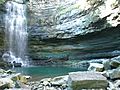
Images for kids
-
Devil's Punch Bowl
-
Chedoke Falls
-
Albion Falls, King's Forest Park


See also
- List of waterfalls in Canada
- Geography of Hamilton, Ontario
