Lunenburg, Nova Scotia facts for kids
Quick facts for kids
Lunenburg
|
||
|---|---|---|
|
Town
|
||

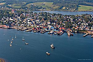
Aerial photo of Lunenburg
|
||
|
||
| Country | Canada | |
| Province | Nova Scotia | |
| County | Lunenburg County | |
| Founded | 1753 | |
| Natal Day | June 7, 1753 | |
| Incorporated | October 31, 1888 | |
| Electoral Districts Federal |
South Shore—St. Margarets |
|
| Provincial | Lunenburg | |
| Government | ||
| • Body | Lunenburg Town Council | |
| Area
(2016)
|
||
| • Land | 4.04 km2 (1.56 sq mi) | |
| Population
(2016)
|
||
| • Total | 2,263 | |
| Time zone | UTC−4 (AST) | |
| • Summer (DST) | UTC−3 (ADT) | |
| Postal code |
B0J
|
|
| Area code(s) | 902 & 782 | |
| Highways | ||
| Website | Town of Lunenburg | |
| Official name: Old Town Lunenburg | ||
| Type: | Cultural | |
| Criteria: | iv, v | |
| Designated: | 1995 (19th session) | |
| Reference #: | 741 | |
| Region: | Europe and North America | |
| Official name: Old Town Lunenburg Historic District National Historic Site of Canada | ||
| Designated: | 1991 | |
| Type: | Heritage Conservation District | |
| Designated: | 2000 | |
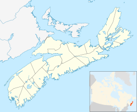
Lunenburg /ˈluːnənbɜːrɡ/ is a charming port town located on the South Shore of Nova Scotia, Canada. It was started way back in 1753. This town was one of the first places where the British tried to settle Protestants in Nova Scotia.
For a long time, Lunenburg's economy was all about fishing in the deep sea. Even today, it has Canada's biggest fish-processing factory! The town became very rich in the late 1800s. Many of its beautiful old buildings come from that time.
In 1995, UNESCO named Lunenburg a World Heritage Site. UNESCO believes it's the best example of a planned British colonial town in North America. It still looks much like it did in the 1800s, with its original street plan and wooden buildings. UNESCO wants to protect the town because its main industry, fishing, faces an uncertain future.
The historic center of Lunenburg is also a National Historic Site of Canada.
Contents
Understanding Lunenburg's Name
Lunenburg got its name in 1753. It was named after a German duke who became King George II of Great Britain. His title was the Duke of Braunschweig-Lüneburg.
Before the British, the Acadian people lived here. They called the area Mirliguèche. This was a French way of spelling a Mi'kmaq name. The Mi'kmaq also had an older name, āseedĭk, which meant "clam-land."
Exploring Lunenburg's Past
Early Inhabitants and European Arrival
The Mi'kmaq people lived in this area for a very long time. Their territory stretched from Lunenburg to Mahone Bay. During warm summer months, as many as 300 Mi'kmaq would live here. French colonists, known as Acadians, also settled in the area around the 1620s.
The Acadians and Mi’kmaq lived peacefully together. Some even married, creating strong family and trade connections. By 1688, there were 10 Acadian and 11 Mi’kmaq families living here. They had homes and small farms.
In 1749, Edward Cornwallis, the new Governor of Nova Scotia, visited. He saw many Mi’kmaq and Acadian families living well together.
British Settlement and Conflicts
In the 1700s, Britain and France were often at war in Europe. These conflicts also spread to North America. In 1713, France gave the part of Acadia that is now Nova Scotia to Britain. To protect against attacks from the Mi'kmaq, Acadians, and French, the British built Fort George in Halifax in 1749. They also founded the town of Halifax.
The British wanted to settle these lands with loyal people. So, in July 1753, they brought over 1,400 "Foreign Protestants" from Europe. These were mostly skilled workers and farmers. Many of these settlers were unhappy in Halifax because they hadn't received the land they were promised. Moving them to Lunenburg helped solve this problem for the British.
The settlers arrived with about 160 soldiers. They quickly put together pre-made blockhouses (small forts). They also built a strong fence around the new village. The settlers spent the summer building homes for the winter. They couldn't fish or farm yet, so supplies had to come from Halifax.
Challenges and Growth
Some settlers became unhappy with how supplies were shared. They also didn't trust the British because of past unfair treatment. This led to a short uprising known as The Lunenburg Rebellion. The settlers even declared a small republic for a brief time. However, British troops quickly stopped the rebellion. Some settlers left and joined the Acadian side. By 1754, Lunenburg had a sawmill and a store.
After the expulsion of the Acadians in 1755, the British needed to fill the empty lands. They offered land grants to colonists from New England. These colonists, called New England Planters, were looking for land.
Lunenburg faced attacks during these times. In 1756, a group of Mi'kmaq and Maliseet raiders attacked the town. This caused a lot of damage. Attacks continued, like the Lunenburg Campaign of 1758. Peace with the Mi'kmaq finally came around 1760.
During the American Revolution, American privateers (armed ships allowed to attack enemy ships) raided Lunenburg. The 1782 raid caused more damage. The town was strengthened at the start of the War of 1812. British officials allowed Lunenburg residents to use their own privateer ship to attack American vessels.
Over the years, Lunenburg's port changed. It moved from local fishing to deep-sea fishing. During the time when alcohol was illegal in the United States (1920-1933), Lunenburg was a base for illegal alcohol trade to the US.
The "Lunenburg Cure" was a special way of drying and salting cod fish. Lunenburg exported this fish to places like the Caribbean. Today, a large copper cod fish weather vane sits on top of St. Andrew's Presbyterian Church.
The Smith & Rhuland shipyard built many famous boats. These include the Bluenose (1921), Bluenose II (1963), and the replica HMS Surprise (1970). After World War II, shipbuilders started making trawlers instead of schooners.
Lunenburg's Location and Environment
Physical Features
Lunenburg is located in a natural harbor on the western side of Mahone Bay. It's about 100 kilometers (62 miles) southwest of Downtown Halifax.
The land here is mostly made of sedimentary rock from ancient times. The last glacial period (Ice Age) shaped the landscape. Glaciers moved across the land, creating hills called drumlins. These drumlins are a key feature of Lunenburg County.
The coastline has many inlets and bays. The town itself is on a narrow strip of land called an isthmus. This strip connects it to the Fairhaven Peninsula. It has harbors on both sides.
Climate and Weather
Lunenburg has a moderate climate because it's on the coast. This means temperatures are not too extreme. Winters are a bit milder, and summers are a bit cooler than other places at the same latitude.
Summers in Lunenburg are warm and breezy. Temperatures are usually in the low to mid-20s °C (70s °F). It's rarely very hot or humid. Winters are cold and often wet. Heavy snow can fall, but it usually doesn't stay long because of frequent winter rains and melting cycles.
Thick fog can happen any time of year, especially in spring. Spring weather arrives late in Lunenburg, often not until mid-May, because the ocean stays cool. The town gets a lot of rain from November to May. July, August, and September are usually the warmest and driest months. Fall is often bright, clear, and cool.
- January: 1°C
- February: 2°C
- March: 5°C
- April: 11°C
- May: 15°C
- June: 21°C
- July: 23°C
- August: 24°C
- September: 21°C
- October: 15°C
- November: 9°C
- December: 4°C
Exploring the Old Town
The original town was planned and built on a steep hillside facing south. It had a grid pattern of narrow streets with small lots. This area is now called the Old Town. It is the part of town protected by UNESCO. It also has the old harbor.
About 40 buildings in the Old Town are listed on the Canadian Register of Historic Places. These include:
- Knaut-Rhuland House, built in 1793: This is now a museum run by the Lunenburg Heritage Society.
- Zion Evangelical Lutheran Church, built in 1890: A large wooden church.
- St. John's Anglican Church, built in 1763: A large wooden church in the Carpenter Gothic style.
The Lunenburg Opera House is also in this area. It was built in 1909, but it's not on the historic registry.
In 2005, the government of Nova Scotia bought 17 buildings along the waterfront. This was to make sure they would be preserved. These buildings are now managed by the Lunenburg Waterfront Association. New shipbuilding facilities were added to the waterfront starting in 2010. This was part of the Bluenose II restoration project.
The old Smith & Rhuland shipyard is now a place for recreational boats.
The Fisheries Museum of the Atlantic, which is part of the Nova Scotia Museum, has a small fleet of boats. This includes the Bluenose II.
Some parts of the waterfront are still used by businesses. The shipyard ABCO Industries was started in 1947. It builds aluminum boats. Lunenburg Shipyard is owned by Lunenburg Industrial Foundry & Engineering. It has a dry dock, manufacturing, a carpentry shop, and a foundry. There are also wharves for commercial fishing boats.
Discovering the New Town
In the 1800s, Lunenburg grew a lot. This was thanks to shipping, trade, fishing, farming, and shipbuilding. The town expanded beyond its original borders. This new area is now called the New Town. It includes about a dozen buildings on the Canadian Register of Historic Places.
How Lunenburg is Governed
In Nova Scotia, there are two levels of government: provincial and municipal. Lunenburg is one of the 50 municipalities in the province.
The town is also part of Lunenburg County. This county was created in the 1860s for court purposes. Today, the county itself doesn't have its own government. However, its borders match certain provincial and federal voting districts. These include the Lunenburg Provincial Electoral District. The county also covers the same area as the Municipality of the District of Lunenburg. This district surrounds, but does not include, Lunenburg, Bridgewater, and Mahone Bay, as they are separate towns.
Lunenburg's Economy and Jobs
According to the 2016 census, the most common jobs in Lunenburg were in sales and services. These made up 24 percent of all jobs. About half of all jobs were in healthcare, social assistance, hotels and restaurants, manufacturing, and retail. High Liner Foods operates Canada's largest fish-processing plant in the town.
Lunenburg's unique buildings and beautiful location make it popular for filming movies and TV shows. For example, important wedding scenes from the Canadian movie Cloudburst were filmed here. Other movies filmed partly in Lunenburg include The Covenant and Dolores Claiborne. The Japanese movie Hanamizuki (2010) was also partly filmed in Lunenburg.
The TV show Haven was partly filmed here for its five seasons. The 2012 film The Disappeared and the TV series Locke & Key (2020) were also filmed in Lunenburg. The fourth season of the TV series The Sinner (2017) also used Lunenburg as a filming location.
Population Information
In the 2021 Census, Lunenburg had a population of 2,396 people. They lived in 1,089 of the town's 1,242 homes. This was a small increase of 5.9% from its 2016 population of 2,263. With a land area of 4.04 square kilometers (1.56 sq mi), the town had a population density of 593.1 people per square kilometer (1,536.2/sq mi) in 2021.
In 2016, most of the people living in Lunenburg were English-speaking Canadian Protestants. The average age in Lunenburg was 58, which is older than the provincial average of 46. Household incomes in Lunenburg were similar to the average incomes across Nova Scotia.
Gallery
-
St. John's Anglican Church, Lunenburg – built during the war (1754-1763)
-
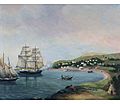
Raid on Lunenburg (1756) by Donald A. Mackay
See also
 In Spanish: Lunenburg para niños
 | Valerie Thomas |
 | Frederick McKinley Jones |
 | George Edward Alcorn Jr. |
 | Thomas Mensah |


