Manning, Alberta facts for kids
Quick facts for kids
Manning
|
|
|---|---|
|
Town
|
|
| Town of Manning | |
 |
|
| Nickname(s):
Land of the Mighty Moose
|
|

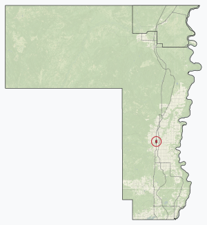
Location in County of Northern Lights
|
|
| Country | Canada |
| Province | Alberta |
| Region | Northern Alberta |
| Planning region | Lower Peace |
| Municipal district | County of Northern Lights |
| Incorporated | |
| • Village | December 31, 1951 |
| • Town | January 1, 1957 |
| Area
(2021)
|
|
| • Land | 3.71 km2 (1.43 sq mi) |
| Elevation | 465 m (1,526 ft) |
| Population
(2021)
|
|
| • Total | 1,126 |
| • Density | 303.1/km2 (785/sq mi) |
| Time zone | UTC−7 (MST) |
| • Summer (DST) | UTC−6 (MDT) |
| Postal code |
T0H 2M0
|
| Area code(s) | -1+780 |
| Highways | Highway 35 Highway 691 |
| Waterway | Notikewin River |
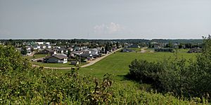
Manning is a small town in northern Alberta, Canada. It's often called the "Land of the Mighty Moose" because of the large moose found there.
The town is located on Highway 35, right by the Notikewin River. It's about 73 km (45 mi) north of another town called Peace River.
Manning is an important place for the local area. It helps support industries like agriculture (farming), forestry (logging), and natural gas. It also provides services to nearby rural communities like Deadwood, Hotchkiss, North Star, and Notikewin.
Contents
History of Manning
Manning started to grow after the First World War. The government wanted to help soldiers returning from the war. They offered land to these veterans so they could start farms. This led to more people moving to the area.
Early Settlement and Healthcare
By 1921, about 500 people lived in the district. A community called Battle River Prairie (later Notikewin) became a local center. In the late 1920s, other communities like Hotchkiss and North Star also began to appear.
At first, there weren't many doctors or nurses in these northern communities. Mobile clinics with Registered Nurses helped provide care. In 1929, a doctor named Mary Percy came from England to serve the area. She worked there until a new hospital was built in 1937.
More farmers moved to the region in the 1930s, especially from southern Alberta where there was a lot of drought. People wanted a hospital, and a church group started raising money for it. The Alberta government agreed to match the funds collected.
Building the Hospital and Founding the Town
Construction on the Battle River Hospital began in late 1936. It was an eight-bed hospital and opened on September 4, 1937. This hospital became a key part of the new Aurora settlement. John Robertson donated the land for the hospital.
The official settlement was founded by Patrick "Pat" Larry Craig. He bought land and built the Aurora hotel and other buildings after the Second World War. The community was first going to be called "Aurora." However, postal authorities said no because it could be confused with Aurora, Ontario.
In 1947, the Mackenzie Highway was built through the region. This made the community a center for government construction. It quickly grew larger than North Star and Notikewin. In 1947, the community was renamed Manning. This was to honor Ernest Manning, who became the Premier of Alberta (like a governor) in 1943. He served as Premier until 1968.
Manning officially became a Village on December 31, 1951. It then became a Town on January 1, 1957. In the 1950s, the Manning Municipal Hospital was built. In 1962, the Great Slave Lake Railway was completed, connecting Manning to the train network.
Climate
Manning has a subarctic climate. This means it has very cold winters and warm summers. The climate data for Manning comes from the nearby settlement of Notikewin.
| Climate data for Notikewin/Manning | |||||||||||||
|---|---|---|---|---|---|---|---|---|---|---|---|---|---|
| Month | Jan | Feb | Mar | Apr | May | Jun | Jul | Aug | Sep | Oct | Nov | Dec | Year |
| Record high °C (°F) | 14 (57) |
12.5 (54.5) |
15 (59) |
26.5 (79.7) |
31.5 (88.7) |
32.7 (90.9) |
33.9 (93.0) |
34.2 (93.6) |
31.5 (88.7) |
26.1 (79.0) |
15 (59) |
12.2 (54.0) |
34.2 (93.6) |
| Mean daily maximum °C (°F) | −10.8 (12.6) |
−6.7 (19.9) |
−1 (30) |
10.1 (50.2) |
16.7 (62.1) |
21 (70) |
22.8 (73.0) |
21.6 (70.9) |
16.6 (61.9) |
8.3 (46.9) |
−3.7 (25.3) |
−7 (19) |
7.3 (45.2) |
| Daily mean °C (°F) | −16.6 (2.1) |
−13.1 (8.4) |
−7.4 (18.7) |
3.4 (38.1) |
9.6 (49.3) |
14.4 (57.9) |
16.2 (61.2) |
14.8 (58.6) |
9.9 (49.8) |
2.4 (36.3) |
−8.8 (16.2) |
−12.7 (9.1) |
1.0 (33.8) |
| Mean daily minimum °C (°F) | −22.3 (−8.1) |
−19.5 (−3.1) |
−13.9 (7.0) |
−3.2 (26.2) |
2.5 (36.5) |
7.7 (45.9) |
9.6 (49.3) |
7.9 (46.2) |
3 (37) |
−3.5 (25.7) |
−13.8 (7.2) |
−18.4 (−1.1) |
−5.3 (22.4) |
| Record low °C (°F) | −51 (−60) |
−49 (−56) |
−40.5 (−40.9) |
−25.9 (−14.6) |
−13.5 (7.7) |
−1.5 (29.3) |
0.3 (32.5) |
−6 (21) |
−9.5 (14.9) |
−27 (−17) |
−39.5 (−39.1) |
−45 (−49) |
−51 (−60) |
| Average precipitation mm (inches) | 37.5 (1.48) |
25.4 (1.00) |
28.3 (1.11) |
18.1 (0.71) |
39.9 (1.57) |
64.2 (2.53) |
85 (3.3) |
50.4 (1.98) |
36.8 (1.45) |
24.4 (0.96) |
44.7 (1.76) |
27.9 (1.10) |
482.6 (18.95) |
Population of Manning
The population of Manning is counted every few years by Statistics Canada. This count is called a census.
|
||||||||||||||||||||||||||||||||||||||||||||||||
In the 2021 Census, Manning had 1,126 people living in 471 homes. This was a small decrease from its 2016 population of 1,183 people. The town covers an area of 3.71 km2 (1.43 sq mi).
Fun Things to Do in Manning
Manning has several attractions and places for recreation.
- The Battle River Pioneer Museum shows off old farming tools, vehicles, and other unique items. You can even see an albino moose there!
- The Manning Farmers’ Market has been a popular spot for over 30 years. You can find fresh local goods there.
For sports and activities, Manning offers:
- The Manning R.C.M.P. Centennial Pool for swimming.
- A paved walking trail for outdoor exercise.
- A curling rink and a skating/hockey arena for ice sports.
- Two outdoor ice rinks for winter fun.
- A ski hill for skiing and snowboarding.
- A concrete skatepark for skateboarding.
- An outdoor splash park for cooling off in summer.
- The Condy Meadows Golf Course and Recreation Area for golf and other activities.
The Battle River Hospital is also a historic site. It was built between 1936 and 1937. This 1+1⁄2-story hospital was named an Alberta Provincial Historic Resource in 2009.
Town Services
Manning has important services for its residents.
- It has a hospital for healthcare needs.
- There is a new RCMP detachment (police station).
- The town also has a fire station and a skatepark.
- There's an indoor and outdoor pool for swimming.
- The Manning Airport is located just outside the town, about 3.3 km northwest.
Schools in Manning
Manning has several schools for students.
- Manning Elementary is part of the Peace River School Division No. 10. It teaches students from kindergarten to grade six.
- Paul Rowe High School is also in the Peace River School Division. It serves students from grades seven through twelve.
- Rosary Separate School is a Catholic school under the Holy Family Catholic Regional Division No. 37. It provides education from kindergarten to grade nine.
Local News
Manning has its own local newspaper called The Banner Post. It is published weekly.
Famous People from Manning
- Dakota House - A Canadian actor, politician, writer, and activist who was born in Manning, Alberta.
 | Emma Amos |
 | Edward Mitchell Bannister |
 | Larry D. Alexander |
 | Ernie Barnes |


