
Marsh Creek (Rogers Creek tributary) facts for kids
Quick facts for kids Marsh Creek |
|
|---|---|

Marsh Creek looking downstream
|
|
| Physical characteristics | |
| Main source | pond in Ross Township, Luzerne County, Pennsylvania between 1,240 and 1,260 feet (380 and 380 m) |
| River mouth | Rogers Creek in Ross Township, Luzerne County, Pennsylvania 971 ft (296 m) 41°13′21″N 76°12′51″W / 41.22237°N 76.21409°W |
| Length | 4.0 mi (6.4 km) |
| Basin features | |
| Progression | Rogers Creek → Huntington Creek → Fishing Creek → Susquehanna River → Chesapeake Bay |
| Basin size | 4.04 sq mi (10.5 km2) |
Marsh Creek is a small river, also called a 'tributary', that flows into Rogers Creek. It's located in Luzerne County, Pennsylvania, USA. This creek is about 4.0 miles (6.4 km) long and runs through Ross Township. The area of land that drains water into Marsh Creek, called its 'watershed', covers about 4.04 square miles (10.5 km2).
Cool fact: wild trout, a type of fish, are born and grow naturally in this creek! You'll find at least one bridge crossing the creek. The small town of Broadway and several wet, marshy areas (called 'wetlands') are also in the creek's watershed. The ground around the creek is made of different types of soil and rock, including some left behind by ancient glaciers.
Contents
Where Marsh Creek Flows

Marsh Creek starts its journey in a pond located in Ross Township. It flows south for a short distance, then turns towards the west-southwest for almost a mile. After that, the creek turns south-southwest for a few miles. Along the way, it picks up water from two smaller streams that join it from the right side.
Finally, Marsh Creek turns south-southwest again for a short stretch. It crosses under State Route 4019 before it meets up with Rogers Creek. Marsh Creek joins Rogers Creek about 2.82 miles (4.54 km) before Rogers Creek reaches its own end.
How Much Water Flows in Marsh Creek?
The amount of water that fills Marsh Creek right up to its banks is called its 'bankfull discharge'. Upstream of a road called Silo Road, this flow is about 17.5 cubic feet per second (0.50 m3/s). Downstream of Silo Road, the bankfull discharge is a bit more, ranging from 16.5 to 22.5 cubic feet per second (0.47 to 0.64 m3/s).
Marsh Creek's Land and Rocks
The elevation near where Marsh Creek joins Rogers Creek is about 971 feet (296 m) above sea level. Where the creek begins, its source, the elevation is higher, between 1,240 and 1,260 feet (380 and 380 m) above sea level.
The bottom of Marsh Creek, called the streambed, is mostly fine sand upstream of Silo Road. Downstream of that road, the streambed changes to coarse gravel. The land along the lower parts of the creek is mainly made of alluvium, which is soil deposited by water. Further away, you can find till, which is rock and soil left by glaciers. There are also areas of bedrock made of sandstone and shale. Near the town of Broadway, you'll find two patches of wetland.
Marsh Creek's Watershed Area
The entire area of land that collects and drains water into Marsh Creek, its watershed, covers about 4.04 square miles (10.5 km2). The part of the watershed that is upstream of Silo Road is about 2.8 square miles (7.3 km2).
The mouth of Marsh Creek is shown on a map called the Shickshinny quadrangle. However, the creek's source is on a different map called the Sweet Valley quadrangle. A large hill separates the northern part of Marsh Creek's watershed from the watershed of Huntington Creek. This hill drops about 400 feet (120 m) from the Marsh Creek side to the Huntington Creek side.
Marsh Creek is located about 11 miles (18 km) north-northwest of where the Bell Bend Nuclear Power Plant is planned to be built. The creek is also close to the small community of Broadway. Silo Road crosses the creek, dividing it into two different sections.
History of Marsh Creek
Marsh Creek was officially added to the Geographic Names Information System on August 2, 1979. This system helps keep track of names for places like rivers and mountains.
Back in 1908, people suggested building a stone arch bridge over Marsh Creek. It was estimated to cost $800.00. Later, in 1936, a different type of bridge was built across Marsh Creek. This bridge was repaired in 2010 and is about 30.8 feet (9.4 m) long.
A special well, called a 'casing well', was once dug on the west bank of Marsh Creek. It went through 72 feet (22 m) of material left behind by glaciers. Also, a school known as the Broadway School used to be located near the creek.
Amazing Animals: Trout Reproduction
Wild trout naturally reproduce in Marsh Creek. This means that from where the creek starts all the way to where it ends, new trout are born and grow up without human help. It's a sign of a healthy stream!
Images for kids
-
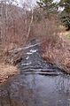
Marsh Creek looking downstream
-
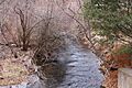
Marsh Creek looking upstream
