Marys Peak facts for kids
Quick facts for kids Marys Peak |
|
|---|---|

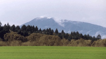
Marys Peak viewed from the Willamette Valley
|
|
| Highest point | |
| Elevation | 4,101 ft (1,250 m) NAVD 88 |
| Prominence | 3,357 ft (1,023 m) |
| Listing | Oregon county high points |
| Naming | |
| Native name | Error {{native name}}: an IETF language tag as parameter {{{1}}} is required (help) |
| Geography | |
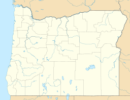
| Location | Benton County, Oregon, U.S. |
| Parent range | |
| Topo map | USGS Lorane |
| Climbing | |
| Easiest route | trail from Marys Peak Road |
Marys Peak is a tall mountain in Benton County, Oregon, United States. It is located southwest of Philomath. The Kalapuya people, who are Native Americans, call this peak "chatímanwi." This name means 'place of spiritual power.' Marys Peak is the highest point in the entire Oregon Coast Range. It is also the highest spot in Benton County.
From the top of Marys Peak, you can see amazing views on a clear day. Looking east, northeast, and southeast, you can spot cities and towns in the Willamette Valley. You can also see the distant Cascade Range mountains. If you look west, you might even see the Pacific Ocean sparkling on a sunny day.
The road to the peak stays open during winter. However, it is not maintained, so you need a special vehicle like a 4x4 or tire chains to drive up safely.
In 2019, the Oregon Geographic Names Board decided to give Native American names to ten creeks on Marys Peak. The Confederated Tribes of the Grand Ronde and Confederated Tribes of Siletz Indians helped choose these names. The names come from the languages of the Kalapuya, Wusi’n, and Yaqo’n people. These groups originally lived on this land. The U.S. Board on Geographic Names officially approved these names in September 2019.
Contents
Marys Peak: Oregon's Tallest Coast Mountain
A Mountain with a Rich History
Native American Heritage
The Kalapuya people have a special name for Marys Peak: "chatímanwi." This name is sometimes written as "tcha Timanwi" or "chintimini." Kalapuya stories tell of their ancestors climbing the mountain to escape a huge flood. Chatímanwi is a very important spiritual place for the Kalapuya. A tribal council member, Brenda Tuomi, described Marys Peak as "a place that's always been our protector, our provider." She said it was "a place where our people could come to feel empowered, come to pray, come to heal."
The Kalapuya people used Marys Peak for hunting and fishing. They also gathered plants like beargrass, hazel, and cedar from the mountain. These plants were used to make clothing and baskets. In 1856, the United States government forced the southern Kalapuya bands to leave their homes, including the Marys Peak area.
Early Settlers and Naming
Early American settlers brought their animals to graze on the mountain. In the late 1800s, a small community called Peak was started on the northwest side of Marys Peak. The post office in Peak closed in 1917, and the community is no longer there today.
The name Marys Peak, given by European settlers, might have come from Mary Lloyd. She arrived in Oregon in 1845. Mary Lloyd was known as the first white woman to cross the Marys River. This river starts on the mountain. However, there are other ideas about how the mountain got its name.
Protecting Water and Helping Kids
The city of Corvallis started using the Rock Creek watershed on Marys Peak for its drinking water in 1906. As logging grew in the area, the Corvallis city government bought land in the watershed. This was done to keep their water clean and safe.
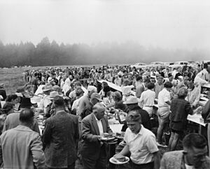
From 1946 to 1984, a group called Shriners International held a yearly picnic on Marys Peak. This event raised money for the Shriners Hospital for Crippled Children. This hospital is now called Shriners Children's Portland. In 1982, a newspaper article reported that the event had raised over $900,000 since it began. In 1984, bad weather caused the event to move to a different location.
Nature's Wonders: Plants and Animals
Unique Plants and Rock Gardens
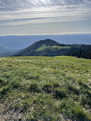
The very top of Marys Peak has a grassland filled with many different kinds of wildflowers. The higher parts of the mountain are mostly covered with noble fir trees. Lower down, you will find Douglas fir and western hemlock trees.
The meadow also has several rocky areas called "rock gardens." These spots have gabbro rock. The most famous rock garden covers about four to five acres on a southern slope near the top. These rock gardens are home to many wildflowers that grow well in thin, dry soil. Some of these flowers include Cascade desertparsley, harsh paintbrush, Olympic onion, and spreading phlox.
In 1989, the Forest Service set aside a 924-acre area on Marys Peak. They called it a Scenic Botanical Special Interest Area. This area includes the summit meadow, stream zones, and parts of the noble fir forest.
Protecting the Meadow Ecosystem
Since the 1950s, noble fir trees have been growing into areas that used to be open meadow on Marys Peak. To protect the meadow ecosystem, the Forest Service removed 3,000 trees from 25 acres of land. This work began in the fall of 2015.
Discovering New Creatures
In 2015, scientists from Oregon State University found a new type of ice crawler on Marys Peak. They identified it as a unique species. It was given the scientific name Grylloblatta chintimini.
 | Shirley Ann Jackson |
 | Garett Morgan |
 | J. Ernest Wilkins Jr. |
 | Elijah McCoy |


