Matawan, New Jersey facts for kids
Quick facts for kids
Matawan, New Jersey
|
||
|---|---|---|
|
Borough
|
||
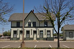
The former Matawan Station
|
||
|
||
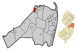
Map of Matawan in Monmouth County. Inset: Location of Monmouth County highlighted in the State of New Jersey.
|
||
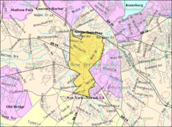
Census Bureau map of Matawan, New Jersey
|
||
| Country | ||
| State | ||
| County | Monmouth | |
| Incorporated | June 28, 1895 | |
| Government | ||
| • Type | Borough | |
| • Body | Borough Council | |
| Area | ||
| • Total | 2.41 sq mi (6.24 km2) | |
| • Land | 2.27 sq mi (5.87 km2) | |
| • Water | 0.14 sq mi (0.37 km2) 5.89% | |
| Area rank | 381st of 565 in state 25th of 53 in county |
|
| Elevation | 10 ft (3 m) | |
| Population
(2020)
|
||
| • Total | 9,565 | |
| • Estimate
(2023)
|
9,704 | |
| • Rank | 252nd of 565 in state 21st of 53 in county |
|
| • Density | 4,221.1/sq mi (1,629.8/km2) | |
| • Density rank | 146th of 565 in state 15th of 53 in county |
|
| Time zone | UTC−05:00 (Eastern (EST)) | |
| • Summer (DST) | UTC−04:00 (Eastern (EDT)) | |
| ZIP Code |
07747
|
|
| Area code(s) | 732 | |
| FIPS code | 3402544520 | |
| GNIS feature ID | 0885293 | |
| Website | ||
Matawan is a small town, called a borough, in Monmouth County, New Jersey. It is a historic place located close to Raritan Bay. Many people who live here travel to New York City for work. In 2020, about 9,565 people lived in Matawan.
Matawan is part of a special plan to make the area's economy stronger. This plan focuses on old downtown areas, neighborhoods, and the natural beauty of the Raritan Bayshore coastline. Matawan is also a "Transit Village," which means it's designed to have homes and businesses close to its train station.
Contents
History of Matawan
The first people to live in this area were the Lenape Native Americans. They called the area "Mechananienk." This name might mean "where two rivers come together" or "bad riverbank." It could also mean "bad fog" or "magician."
Dutch settlers came to Matawan in the 1600s. Later, in 1686, settlers from New Hampshire named the town New Aberdeen. It was also called Mount Pleasant. The town grew around a church and a few houses. As docks were built along Matawan Creek, the area became known as Middletown Point. This helped trade and business grow a lot.
By the mid-1700s, Matawan was a main spot for sending and receiving goods by water in Monmouth County. Wealthy merchants and traders built their homes along Main Street. Many of these old homes are still there today.
Matawan During the Revolutionary War
On May 27, 1778, the Burrowes Mansion was the site of a small battle during the Revolutionary War. The mansion was built in 1723 and owned by John Burrowes Sr. His son, John Burrowes Jr., trained local soldiers in their front yard. These soldiers were part of the first New Jersey Company of the Continental Army.
Local Patriots used small boats to attack British ships in Raritan Bay. In response, British soldiers attacked Matawan. They wanted to burn warehouses and mills owned by Burrowes and capture John Burrowes Jr. John Burrowes Jr. escaped by swimming across Matawan Creek. However, his father and other Patriots were captured.
Another battle happened near the Forman house in 1779. American soldiers forced the British to retreat. This house became known as the "Old Hospital" because wounded soldiers were cared for there. A famous poet of the Revolution, Philip Freneau, lived here and started Monmouth County's first newspaper in 1795.
Growth and Changes in Matawan
In the 1830s, Matawan grew even more with the invention of the steamboat. This made it easier to send goods to New York. Between 1820 and 1870, new streets and homes were built. Lumber mills, shipping warehouses, and brickyards were also started.
In 1865, the Middletown Point post office was renamed "Matawan." This was to avoid confusion with another town called Middletown. The Matawan Train Station opened in 1875. This helped the town stay important for transportation as the creek became too shallow for large ships.
Matawan became an official borough on June 28, 1895. This happened after people voted for the change. Over the years, Matawan grew by adding parts of nearby townships.
The 1916 Shark Attacks
Even though Matawan is about 11 miles from the Atlantic Ocean, it was the site of three shark attacks on July 12, 1916. These attacks happened in Matawan Creek and caused two deaths. They were part of a series of shark attacks along the Jersey Shore that summer. Today, you can see a shark mural in Matawan Creek.
Matawan in the 20th Century
In 1894, a new brick school building was built. A big fire in 1901 destroyed six buildings in the main business area. In 1923, Lake Matawan was created by building a dam. Lake Lefferts was created in 1928. Many parks were also established to honor veterans and provide green spaces.
In 1944, Matawan played a role in aviation history. The first special system to help airplanes navigate, called Visual Aural Range (VAR), was installed here. This system helped planes find their way and later led to the VOR system used today.
Geography of Matawan
Matawan covers about 2.41 square miles (6.24 km2). Most of this area is land, with a small part being water. The borough is located in the northwest corner of Monmouth County. It is also one of the highest parts of the county.
Matawan borders Aberdeen Township and Marlboro Township in Monmouth County. It also borders Old Bridge Township in Middlesex County. Matawan actually divides Aberdeen Township into two separate parts.
Matawan's Population
| Historical population | |||
|---|---|---|---|
| Census | Pop. | %± | |
| 1880 | 1,437 | — | |
| 1890 | 1,491 | 3.8% | |
| 1900 | 1,511 | 1.3% | |
| 1910 | 1,645 | 8.9% | |
| 1920 | 1,910 | 16.1% | |
| 1930 | 2,264 | 18.5% | |
| 1940 | 2,758 | 21.8% | |
| 1950 | 3,739 | 35.6% | |
| 1960 | 5,097 | 36.3% | |
| 1970 | 9,136 | 79.2% | |
| 1980 | 8,837 | −3.3% | |
| 1990 | 9,270 | 4.9% | |
| 2000 | 8,910 | −3.9% | |
| 2010 | 8,810 | −1.1% | |
| 2020 | 9,565 | 8.6% | |
| 2023 (est.) | 9,704 | 10.1% | |
| Population sources: 1880–1890 1890–1920 1890–1910 1910–1930 1940–2000 2000 2010 2020 |
|||
In 2010, Matawan had 8,810 people living in 3,358 households. About 32.3% of these households had children under 18. Most households (53.0%) were married couples.
The population was mostly White (80.98%), with smaller groups of Black or African American (7.04%) and Asian (6.41%) residents. About 10.77% of the population was Hispanic or Latino. The average age of people in Matawan was 38.3 years old.
Arts and Culture in Matawan
Matawan is a great place for families. In 2007, BusinessWeek magazine ranked it #12 in the nation for "The 50 Best Places to Raise Your Kids." It's also considered one of the safest small towns in the United States.
Matawan is known as an Arts, Cultural, and Entertainment (ACE) Hub. This means it has many arts and cultural activities for both visitors and locals. It's one of only eight towns in Monmouth County with this special designation.
Community Events and Celebrations
Matawan hosts many fun community events throughout the year. The biggest event is Matawan Day, held every October on Main Street. It features local businesses, artists, music, food, and activities for kids.
From June to October, there's a farmers' market every Friday. The town also has an annual yard sale in May and a "Blues and Cruise Night" car show. Matawan celebrates most holidays with special events. These include New Jersey's shortest St. Patrick's Day Parade, an Easter egg hunt, a Memorial Day parade, and Christmas tree lighting.
Historic Sites and Architecture
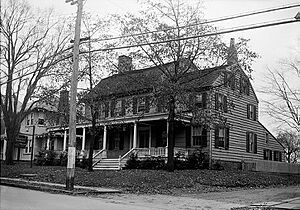
The main historic site in Matawan is the Maj. John Burrowes Mansion museum. This mansion was built in 1723 and is a beautiful example of Georgian style. It was home to Maj. John Burrowes, a hero of the American Revolutionary War. The mansion is listed on the National Register of Historic Places.
Main Street and nearby streets have many historic houses and buildings from the 1700s, 1800s, and early 1900s. You can see many different architectural styles, like Greek Revival, Queen Anne, and Italianate. The Matawan Historical Society can tell you more about the people who lived in these homes.
Parks and Recreation in Matawan
Matawan is the starting point for parts of the Henry Hudson Trail, a popular path for walking and biking. You can see great views of Lake Matawan from different spots in town.
Matawan has ten parks for everyone to enjoy:
- Lake Lefferts: A lake where you can launch boats, fish, and rent canoes, kayaks, and paddleboats.
- Memorial Park: This park has several memorials, including ones for local firefighters, 9/11, and veterans from different wars.
- Gravelly Brook Park: A playground with soccer and baseball fields, basketball courts, and bathrooms.
- Clinton Street Youth Center: Features a basketball court, handball wall, and playground.
- Jeremiah E. Hourihan Field: A ballfield and playground.
- Joseph Penniplede Park: Has a basketball court, playground, and handball wall.
- Terhune Park: A playground.
- The Pocket Park: A small park next to the Post Office.
- Toomer Baseball Field
- Freneau Baseball Field
Education in Matawan
Matawan is part of the Matawan-Aberdeen Regional School District (MARSD). This school district also serves students from Aberdeen Township. The district has seven schools for students from pre-kindergarten to 12th grade.
The schools in the district include:
- Cambridge Park Elementary School (PreK–K)
- Cliffwood Elementary School (PreK–3)
- Ravine Drive Elementary School (PreK–3)
- Strathmore Elementary School (PreK–3)
- Lloyd Road Elementary School (grades 4–5)
- Matawan Aberdeen Middle School (grades 6–8)
- Matawan Regional High School (grades 9–12)
The school district has about 3,950 students and 352 teachers. This means there are about 11 students for every teacher.
Transportation in Matawan
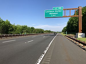
Matawan has many roads for getting around. These include Route 34, Route 79, and County Route 516. The Garden State Parkway also passes near the northern part of the borough.
Matawan is well-known for its busy train station, Aberdeen-Matawan. You can take NJ Transit trains from here on the North Jersey Coast Line. These trains go to New York City's Penn Station. It's the busiest train station in Monmouth County, with about 2,500 people getting on trains each day.
NJ Transit also offers bus service from Matawan to Midtown Manhattan. There are two bus routes, the 133 and the 135.
Notable People from Matawan
Many interesting people have lived in or are connected to Matawan:
- Monica Aksamit (born 1990), an Olympic saber fencer who won a bronze medal in 2016.
- Joseph D. Bedle (1821–1894), who was the 23rd Governor of New Jersey.
- Ryan Buggle (born 2010), a young actor and dancer.
- Gerard Canonico (born 1989), a stage actor.
- Connor Clifton (born 1995), an ice hockey player for the Boston Bruins.
- Robert D. Clifton (born 1968), a politician who was Mayor of Matawan.
- Terry Deitz (born 1959), who finished third on the TV show Survivor: Panama.
- Edward P. Felt (1959–2001), a passenger on United Airlines Flight 93 on 9/11.
- Philip Freneau (1752–1832), a famous poet during the American Revolutionary War.
- Elmer H. Geran (1875–1964), who represented New Jersey in Congress.
- Delores Holmes (born 1946), a soul singer.
- Erison Hurtault (born 1984), an Olympic 400m track runner.
- Jim Jeffcoat (born 1961), a professional football player for the Dallas Cowboys.
- Howard Kremer (born 1971), a comedian.
- Bob McKenty, a poet.
- Richard Reines, a music executive who co-owns Drive-Thru Records.
- Anthony Sesely (born 1983), a professional stock car racing driver.
- William H. Sutphin (1887–1972), who represented New Jersey in Congress and was Mayor of Matawan.
- Thom Wasluck, a musician.
- Jacqueline Walker (born 1941), a politician.
- Greg Wyshynski (born 1977), a sportswriter.
- Jimmy Yacabonis (born 1992), a professional baseball pitcher.
See also
 In Spanish: Matawan (Nueva Jersey) para niños
 | May Edward Chinn |
 | Rebecca Cole |
 | Alexa Canady |
 | Dorothy Lavinia Brown |


