
Matinicus Isle, Maine facts for kids
Quick facts for kids
Matinicus Island, Maine
|
|
|---|---|
|
Plantation
|
|

View of the harbor c. 1908
|
|

Location in Knox County and the state of Maine.
|
|
| Country | United States |
| State | Maine |
| County | Knox |
| Organized | 1840 |
| Area | |
| • Total | 9.9 sq mi (26 km2) |
| • Land | 2.3 sq mi (6 km2) |
| • Water | 7.6 sq mi (20 km2) |
| Elevation | 0-100 ft (0-30.5 m) |
| Population
(2020)
|
|
| • Total | 53 |
| • Density | 5.35/sq mi (2.04/km2) |
| Time zone | UTC-5 (Eastern (EST)) |
| • Summer (DST) | UTC-4 (EDT) |
| Zip code |
04851
|
| Area code(s) | 207 |
| FIPS code | 23-44165 |
| GNIS feature ID | 0582584 |
Matinicus Isle is a small island community in Knox County, Maine, United States. It is located in Penobscot Bay, about 20 miles east of the mainland. You can reach Matinicus by state ferry from Rockland or by air taxi from Knox County Regional Airport. Matinicus is the farthest inhabited land off the east coast of the United States into the Atlantic Ocean. It is home to a small number of people all year, and also a popular place for summer visitors. In 2020, 53 people lived on the island.
Contents
Island History: Matinicus Isle's Past
Matinicus is an Abenaki word that means "far out island." This name perfectly describes its location.
Early Island Life: Native Americans and Europeans
Native American people likely used the island for hunting and gathering for a long time. Europeans probably started visiting Matinicus in the 1500s. The island is mentioned in old records from 1717. Sailors said that pirates from the ship Whydah took their trading ship near Cape Cod. The pirates then sailed north to Matinicus. There, they took several other boats, including a sloop and three schooners.
First Settlers and Conflicts
In 1750, Ebenezer Hall became the first person to live on Matinicus permanently. He moved there with his family. He built a house and started fishing and farming. Hall claimed the island as his own. He even burned grass on nearby Green Island to make hay for his livestock. This made the Penobscot tribe very angry. They still used the islands for fishing and hunting seals.
The Penobscot tribe wrote two letters to the Royal authorities in Boston. They complained about Hall. In their second letter, sent on April 25, 1753, they warned: "if you don't remove him in two months, we shall be obliged to do it ourselves." Hall was told to leave Matinicus, but he stayed. The Penobscots waited over four years. On June 10, 1757, after a long siege on his house, they killed Hall.
Island Growth and Organization
After Hall's death, several families, including his son's, moved to the island. By 1790, 59 people lived there. The population kept growing. On October 22, 1840, Matinicus was officially organized as a plantation.

As a community by the sea, people on Matinicus have always worked as sailors and fishermen. In the past, they fished for cod, mackerel, and herring. Now, lobster fishing is the main industry on the island. This industry is very important for the islanders. Sometimes, there have been disagreements over fishing areas.
Community Life and Services
Matinicus has one church, the Congregational Church of Matinicus. It was built in 1906. Today, it holds Sunday services in the summer. It also serves as a community hall for events. The island is a regular stop for the Maine Seacoast Mission's boat, the Sunbeam. This boat offers pastoral care (spiritual support), nursing care, and telemedicine (medical help over distance).
The islanders are also brave first responders. They help with emergencies in the waters of Penobscot Bay. For example, on January 16, 1992, Matinicus residents helped a sinking tugboat called the O.A. Harkness. They rescued all three crew members. On July 17, 2011, island fishermen rescued four people from an airplane that landed in the water near Matinicus.
Island Geography: Matinicus's Location
.jpg)
Matinicus Isle is a group of islands. It is located on the southeastern edge of Penobscot Bay in the Gulf of Maine. This area is part of the Atlantic Ocean. The total area of the plantation is about 9.9 square miles (26 square kilometers). About 2.3 square miles (6 square kilometers) is land, and 7.6 square miles (20 square kilometers) is water.
Matinicus Island is the largest piece of land in the group. It is about 2 miles (3.2 km) long and 1 mile (1.6 km) wide. Its area is about 720 acres (290 hectares). The island's height above sea level ranges from 0 to 100 feet (0 to 30.5 meters).
The shoreline of Matinicus has rocky coves and sandy beaches. The island experiences semidiurnal tides. This means there are two high tides and two low tides each day. The sea level can change by up to 10-11 feet (3-3.4 meters) between high and low tides.
There are ten main fishing spots around Matinicus Isle. The island's fishermen use these spots to catch fish like cod, haddock, pollock, cusk, and lobster.
Island Climate: Weather on Matinicus
Matinicus has a humid continental climate. This means it has warm, humid summers and cold winters. The Atlantic Ocean helps to make the weather less extreme than on the mainland. Summers are a bit cooler, and winters are a bit milder. Strong winter storms called Nor'easters can cause damage to the shoreline and buildings on the island. An example is the Blizzard of 1978.
Island Population: Who Lives on Matinicus
| Historical population | |||
|---|---|---|---|
| Census | Pop. | %± | |
| 1790 | 59 | — | |
| 1800 | 53 | −10.2% | |
| 1810 | 95 | 79.2% | |
| 1820 | 105 | 10.5% | |
| 1830 | 145 | 38.1% | |
| 1840 | 192 | 32.4% | |
| 1850 | 220 | 14.6% | |
| 1860 | 276 | 25.5% | |
| 1870 | 277 | 0.4% | |
| 1880 | 243 | −12.3% | |
| 1890 | 196 | −19.3% | |
| 1900 | 184 | −6.1% | |
| 1910 | 179 | −2.7% | |
| 1920 | 140 | −21.8% | |
| 1930 | 156 | 11.4% | |
| 1940 | 112 | −28.2% | |
| 1950 | 188 | 67.9% | |
| 1960 | 100 | −46.8% | |
| 1970 | 90 | −10.0% | |
| 1980 | 66 | −26.7% | |
| 1990 | 67 | 1.5% | |
| 2000 | 51 | −23.9% | |
| 2010 | 74 | 45.1% | |
| 2020 | 53 | −28.4% | |
| U.S. Decennial Census | |||
In 2010, there were 74 people living on Matinicus. They lived in 41 households, and 16 of these were families. The population density was about 32 people per square mile.
The average age of people on the island was 47 years old. About 20% of the population was under 19 years old. Most people (66%) were between 20 and 64 years old. About 14% were between 65 and 84 years old. Slightly more than half (54%) of the population was male, and 46% was female. All the residents were white.
The average household had 1.8 people. The average family had 2.8 people. About 17% of households had people under 18 years old. About 22% had people over 64 years old. About 34% of households were married couples living together. Most households (61%) were not families.
There were 147 housing units on the island. About 41 homes were lived in all year. The other 99 homes were used for seasonal visits, recreation, or occasionally.
In 2015, the average income per person on the island was $28,801. The average income for a household was $67,000. The average income for a family was $123,354. About 22% of the population was living below the poverty line.
Images for kids
-
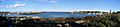
Panorama of the harbor in 2006
See also
 In Spanish: Matinicus Isle para niños
