
Mineral Mountain (Washington) facts for kids
Quick facts for kids Mineral Mountain |
|
|---|---|

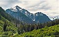
Mineral Mountain seen from Copper Ridge
|
|
| Highest point | |
| Elevation | 6,800+ ft (2,070+ m) |
| Prominence | 2,080 ft (630 m) |
| Isolation | 3.15 mi (5.07 km) |
| Parent peak | Ruth Mountain (7,115 ft) |
| Geography | |

Mineral Mountain
Location in Washington (state)

Mineral Mountain
Location in the United States
|
|
| Location | North Cascades National Park Whatcom County, Washington, U.S. |
| Parent range | Cascade Range North Cascades Skagit Range |
| Topo map | USGS Mount Blum |
| Climbing | |
| Easiest route | Scramble |
Mineral Mountain is a tall peak, about 6,800 feet (2,073 meters) high. It's found in the Skagit Range, which is part of the North Cascades in Washington state.
This mountain is inside North Cascades National Park. From its top, you can see amazing views of other peaks like Mount Shuksan, Icy Peak, and the Picket Range. Easy Peak is about 2 miles (3.2 km) to the east. The closest taller mountain is Ruth Mountain, which is about 3 miles (4.9 km) to the west.
Rain and melting snow from Mineral Mountain flow into two main rivers. Some water goes north into the Chilliwack River, and some goes south into the Baker River.
Weather and Climate Around Mineral Mountain
Mineral Mountain is in a special weather zone called the marine west coast climate. This means it's near the ocean, which affects its weather. Most weather systems start over the Pacific Ocean. They then move northeast towards the Cascade Mountains.
When these weather systems reach the North Cascades, the tall mountains force the air to rise. As the air goes up, it cools down and drops its moisture. This causes a lot of rain or snowfall on the western side of the North Cascades. This happens especially during the winter months.
In winter, the weather is often cloudy. But in summer, high pressure systems over the Pacific Ocean bring clear skies. This means there's usually little or no cloud cover. Because of the ocean's influence, the snow here can be wet and heavy. This can lead to a high risk of avalanches. The best time to visit or climb Mineral Mountain is from July to September. This is when the weather is usually the nicest.
How Mineral Mountain Was Formed
The North Cascades has some very rugged land. You can see sharp peaks, long ridges, and deep valleys carved by glaciers. These amazing landscapes were created by geological events that happened millions of years ago. These events caused big changes in elevation, which also led to different climates.

The Cascade Range started forming millions of years ago, during the late Eocene Epoch. The North American Plate was slowly moving over the Pacific Plate. This movement caused many volcanic eruptions. Also, small pieces of the Earth's crust, called terranes, joined together. This helped create the North Cascades about 50 million years ago.
During the Pleistocene period, which was over two million years ago, glaciers moved across the land many times. As they moved, they scraped away rock and left behind debris. The river valleys you see today are shaped like a "U" because of these glaciers. The combination of land being pushed up (called uplift) and cracks in the Earth's crust (called faulting) with glaciation has created the tall peaks and deep valleys of the North Cascades.
Images for kids
-
Northeast aspect, from Chilliwack River valley

