Mores Creek Summit facts for kids
Quick facts for kids Mores Creek Summit |
|
|---|---|
| Elevation | 6,118 ft (1,865 m) |
| Traversed by | |
| Location | Boise County, Idaho, US |
| Range | Boise Mountains, Central Idaho Mountains |
| Coordinates | 43°55′55.5″N 115°40′5″W / 43.932083°N 115.66806°W |
| Topo map | caltopo map |
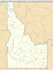
Mores Creek Summit is a mountain pass located in the beautiful Boise Mountains of southwest Idaho, United States. Imagine a high point where a road crosses over a mountain range – that's a mountain pass! This summit sits at an elevation of 6,118 feet (about 1,865 meters) above sea level. That's like being on top of a really tall building!
You can find Mores Creek Summit along Idaho State Highway 21, which is also known as the Ponderosa Pine Scenic Byway. This road is famous for its amazing views of tall pine trees and natural landscapes. The summit is in Boise County, Idaho, right inside the huge Boise National Forest.
Contents
What is a Mountain Pass?
A mountain pass is like a natural gateway through mountains. It's the lowest or easiest path to cross a mountain range. People have used passes for thousands of years to travel, trade, and explore. Mores Creek Summit helps connect different areas of Idaho.
Where is Mores Creek Summit?
This summit is an important spot because it marks a "divide" between two major river drainage areas. Think of it as a natural line on the ground where rainwater decides which way to flow. On one side, water flows towards the North Fork of the Boise River. On the other side, it flows towards the South Fork of the Payette River.
The summit is located between two towns: Idaho City and Lowman. These towns are popular spots for people who love outdoor activities in the Boise National Forest.
Mores Creek
Mores Creek itself is a small stream that flows into the Boise River. A stream or river that flows into a larger river is called a tributary. Mores Creek is named after a gold miner, and the area around it has a rich history of mining.
The Ponderosa Pine Scenic Byway
Idaho State Highway 21, which crosses Mores Creek Summit, is part of the Ponderosa Pine Scenic Byway. This byway is a special road recognized for its natural beauty and history. It winds through forests, mountains, and along rivers, offering stunning views of Idaho's wilderness. Driving this road is a great way to see the diverse landscapes of the region, including the tall Ponderosa Pine trees that give the byway its name.
 | Shirley Ann Jackson |
 | Garett Morgan |
 | J. Ernest Wilkins Jr. |
 | Elijah McCoy |


