
Mount Constance facts for kids
Quick facts for kids Mount Constance |
|
|---|---|

View from U.S. Highway 101 in Dosewallips State Park
|
|
| Highest point | |
| Elevation | 7,756 ft (2,364 m) |
| Prominence | 1,956 ft (596 m) |
| Isolation | 5.67 mi (9.12 km) |
| Parent peak | Mount Deception (7,788 ft) |
| Geography | |

Mount Constance
Location in Washington (state)

Mount Constance
Location in the United States
|
|
| Location | Jefferson County, Washington, U.S. |
| Parent range | Olympic Mountains |
| Topo map | USGS Mount Deception |
| Geology | |
| Age of rock | Eocene |
| Type of rock | Basalt |
| Climbing | |
| First ascent | 1922 by Robert Schellin and A.E. Smith |
| Easiest route | Rock & Ice climb |
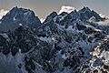
Mount Constance is a tall mountain in the Olympic Mountains of Washington state. It is the third highest peak in this mountain range. If you look at the western sky from Seattle, Mount Constance is the most noticeable mountain you will see.
Even though it's almost as tall as Mount Olympus, Mount Constance doesn't have many large glaciers or much permanent snow. This is because the eastern part of the Olympic Mountains gets less rain and snow. But there is still a small, steep glacier called the Crystal Glacier on the mountain's north side. It has a tiny lake at its end. The trees also grow higher up on Mount Constance than on mountains to the west, which shows it's a drier area.
Mount Constance is located at the eastern edge of the Olympic Mountains. This means it rises very high from the land around it. For example, it climbs over 6,900 feet (2,100 meters) above the Dosewallips River in just 3 miles (5 kilometers). It is also only about 12 miles (19 km) from the Hood Canal, which is part of the ocean. The top of Mount Constance is on the border between Olympic National Park and Buckhorn Wilderness. The area around Mount Constance includes other peaks like Inner Constance and Warrior. It also has many rocky ridges and a basin with Lake Constance.
Contents
History of Mount Constance
In 1853, a surveyor named George Davidson gave names to three mountains in the Olympics. He named Mount Ellinor after Ellinor Fauntleroy, who later became his wife. He named Mount Constance after Ellinor's older sister. He also named The Brothers after Ellinor's two brothers.
In September 1941, a U.S. Army bomber plane crashed near the top of Mount Constance. It crashed about 800 feet (240 meters) below the peak. All six people on board died in the accident.
Weather and Climate

Mount Constance is in a marine west coast climate zone. This means it gets a lot of moisture from the Pacific Ocean. Most weather fronts come from the Pacific and move northeast towards the Olympic Mountains. When these weather fronts hit the tall peaks, they are forced to rise. This causes them to drop their moisture as rain or snow. This process is called Orographic lift.
Because of this, the Olympic Mountains get a lot of rain and snow, especially in winter. The snow tends to be wet and heavy, which can create a risk of avalanches. In winter, the weather is often cloudy. But in summer, high-pressure systems over the Pacific Ocean often bring clear skies. The best time to visit or climb Mount Constance is usually from July to September.
How Mount Constance Was Formed
The Olympic Mountains are made of different kinds of rock, including sandstone, turbidite, and basalt. These rocks were formed from ocean crust material. The mountains were shaped over millions of years by erosion and by glaciers. These glaciers moved forward and backward many times during the Pleistocene era, carving out the landscape we see today.
Climbing Mount Constance
Mount Constance was first climbed in 1922 by R. Schellin and A.E. Smith. They climbed it from the southeast side. There are different climbing routes on the mountain. Some are easier, like Class 3, while others are more difficult, up to mid-Class 5.
How to Get to Mount Constance
There are several ways to reach the Mount Constance area. One way is through the Buckhorn Wilderness Area. You can use the Upper Dungeness River Trail and Marmot Pass. This path leads to areas like Boulder Ridge and Home Lake.
Another way to get to Mount Constance is by using the Dosewallips River Trailhead. This trailhead is off of US 101 and Hood Canal.
A third option is to use logging roads near Quilcene. These roads, like FS 2700 (also called "Penny Creek Road"), lead to Tunnel Creek Ridge. From there, it's a shorter climb to Harrison Lake. These roads also offer amazing views of the east side of Mount Constance and Warrior Peak. Some parts of these roads are paved, and they connect to other areas like Dungeness and Sequim through Bon Jon Pass.
Images for kids
-
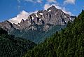
Mt. Constance from ENE (Tunnel Creek area)
-
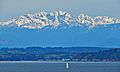
Constance from West Seattle
-
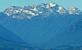
Constance seen from Hood Canal
-
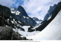
Avalanche Canyon of Mt. Constance
-
North aspect of Constance from Buckhorn Mountain
.jpg)


