
Mount Hermann facts for kids
Quick facts for kids Mount Hermann |
|
|---|---|

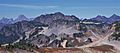
Mount Hermann centered above Table Mountain
|
|
| Highest point | |
| Elevation | 6,240 ft (1,900 m) |
| Prominence | 1,120 ft (340 m) |
| Isolation | 3.55 mi (5.71 km) |
| Parent peak | Lasiocarpa Ridge |
| Geography | |

Mount Hermann
Location in Washington (state)

Mount Hermann
Location in the United States
|
|
| Location |
|
| Parent range | Cascade Range North Cascades Skagit Range |
| Topo map | USGS Shuksan Arm |
| Geology | |
| Volcanic arc | Cascade Volcanic Arc |
Mount Hermann is a tall mountain in the North Cascades of Washington state. It stands about 6,240 feet (1,900 meters) high. You can find it northwest of Mount Shuksan and northeast of Mount Baker. This mountain is part of the Skagit Range.
Mount Hermann is located inside the Mount Baker Wilderness. This land is looked after by the Mount Baker-Snoqualmie National Forest. It's also right next to the Mt. Baker Ski Area, at the end of the Mount Baker Highway. Water from the mountain flows into the Nooksack River.
The mountain is named after Binger Hermann, who was in charge of the U.S. General Land Office. People sometimes called it "Mount Herman" or "Herman Peak." But in 1988, the U.S. Board on Geographic Names officially decided on the name "Mount Hermann."
Weather and Climate at Mount Hermann

Mount Hermann is in a special climate zone called the marine west coast climate. This type of weather is common in western North America. Most of the weather comes from the Pacific Ocean. It travels northeast towards the Cascade Mountains.
When weather fronts reach the North Cascades, the tall mountains force the air upwards. This process is called Orographic lift. As the air rises, it cools down and drops its moisture. This means the west side of the North Cascades gets a lot of rain or snow.
Mount Hermann is very close to the Mt. Baker Ski Area. This area once had the most snowfall in the world for one season! In 1998–1999, it got an amazing 1,140 inches (95 feet or 29 meters) of snow.
During winter, it's usually cloudy. But in summer, high pressure systems over the Pacific Ocean bring clear skies. Because of the ocean's influence, the snow here is often wet and heavy. This can lead to a high risk of avalanches. The best time to visit or climb Mount Hermann is from July to September. The weather is usually the nicest then.
How Mount Hermann Was Formed

The North Cascades area has some of the roughest land in the Cascade Range. You can see jagged peaks, long ridges, and deep valleys carved by glaciers. These amazing shapes and big changes in height were created by geological events over millions of years.
The Cascade Mountains started forming a very long time ago, in the late Eocene Epoch. This was when the North American Plate slowly moved over the Pacific Plate. This movement caused many volcanic eruptions. Mount Baker, a large volcano, began to form about 8 miles (13 km) southwest of Mount Hermann.
Small pieces of the Earth's crust, called terranes, also helped create the North Cascades. This happened about 50 million years ago.
During the Pleistocene period, which was over two million years ago, glaciers moved across the land many times. As they advanced and retreated, they scraped away the landscape. They left behind piles of rock debris. The "U"-shaped valleys you see today were formed by these glaciers.
The main forces that created the tall peaks and deep valleys of the North Cascades are uplift (when land rises) and faulting (when cracks form in the Earth's crust), along with the action of glaciers.
Images for kids
-
Mount Hermann centered above Table Mountain
-
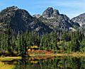
Mt. Hermann
-
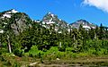
Mt. Hermann


