
National Register of Historic Places listings in Carroll County, New Hampshire facts for kids

Imagine a special list of places in the United States that are super important because of their history! The National Register of Historic Places is like a hall of fame for buildings, sites, and objects that tell amazing stories about our past. In Carroll County, New Hampshire, there are many such places. These special spots help us remember and learn about how people lived long ago. They show us important events and unique ways of building things.
There are 59 historic properties and areas listed in Carroll County. One of these is even a National Historic Landmark, which means it's extra special!
Contents
- Exploring Historic Places in Carroll County, New Hampshire
- What is the National Register of Historic Places?
- Why are these places important?
- Some Amazing Historic Spots in Carroll County
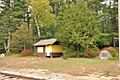
- Abenaki Indian Shop and Camp
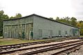
- Bartlett Roundhouse
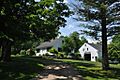
- Beede Farm
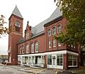
- Brewster Memorial Hall
- Carroll County Court House
- Center Sandwich Historic District
- Chocorua Lake Basin Historic District
- Cook Memorial Library
- Durgin Bridge
- Eagle Mountain House
- Eastern Slope Inn
- Joy Farm
- Libby Museum
- Moultonborough Town House
- North Conway Depot and Railroad Yard
- Russell-Colbath House
- St. John's Church, Rectory, and Parish Hall
- Town Hall (Sandwich, New Hampshire)
- Wakefield Public Library
- Whittier Bridge
- Images for kids
Exploring Historic Places in Carroll County, New Hampshire
What is the National Register of Historic Places?
The National Register of Historic Places is the official list of the nation's historic places. It is part of a program to coordinate and support public and private efforts to identify, evaluate, and protect America's historic and archaeological resources. When a place is added to this list, it means it has been recognized for its importance to history, architecture, archaeology, engineering, or culture.
Why are these places important?
These historic places are like giant storybooks. They help us understand what life was like in the past. For example, an old schoolhouse can show us how children learned many years ago. A historic home can reveal how families lived and worked. By protecting these places, we make sure that future generations can also learn from them. They are a link to our past and help us appreciate our heritage.
Some Amazing Historic Spots in Carroll County
Carroll County is full of interesting historic places. Here are just a few examples of the different kinds of sites you can find on the National Register.
Abenaki Indian Shop and Camp
The Abenaki Indian Shop and Camp is located in Conway, New Hampshire. It was added to the National Register in 1991. This site was once a shop and camp for the Abenaki people, a Native American tribe. Today, it is a town park. It helps us remember the history and culture of the Abenaki people in this area.
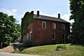
Bartlett Roundhouse
In Bartlett, New Hampshire, you can find the Bartlett Roundhouse. This building was listed in 2015. A roundhouse is a special building used to store and repair locomotives (train engines). It shows the important role trains played in connecting towns and moving goods in the past.
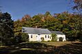
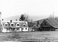
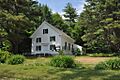
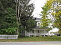
Beede Farm
The Beede Farm is in Sandwich, New Hampshire. It became a historic place in 2012. This farm is part of a larger group of historic sites around Squam Lake. Farms like Beede Farm show us how people used to live off the land and the history of farming in New Hampshire.
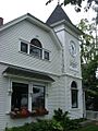
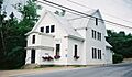
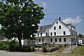
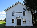
Brewster Memorial Hall
The Brewster Memorial Hall is a beautiful building in Wolfeboro, New Hampshire. It was listed in 1983. This hall likely served as a community gathering place. It reminds us of the importance of public buildings in town life.
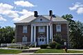
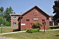
Carroll County Court House
The Carroll County Court House is located in Ossipee, New Hampshire. It was added to the National Register in 2007. This building is where important legal decisions for the county have been made for many years. It represents the history of law and government in Carroll County.
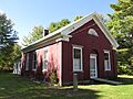
Center Sandwich Historic District
The Center Sandwich Historic District is a whole area in Sandwich, New Hampshire, that is considered historic. It was listed in 1983. This district includes many old buildings and streets. Walking through it is like stepping back in time to see how a New England village looked long ago.
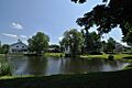
Chocorua Lake Basin Historic District
Another historic district is the Chocorua Lake Basin Historic District in Tamworth, New Hampshire. This area, listed in 2005, includes parts of roads and lands around the beautiful Chocorua Lake. It shows how people lived and interacted with the natural landscape in the past.
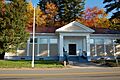
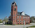
Cook Memorial Library
The Cook Memorial Library in Tamworth, New Hampshire, became a historic site in 1980. Libraries are often important community centers. This building has likely served as a place for learning and reading for many generations.
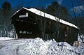
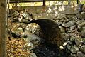
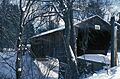
Durgin Bridge
The Durgin Bridge is a historic bridge in Sandwich, New Hampshire. It was listed in 1983. This bridge crosses the Cold River. Old bridges are important examples of early engineering and how people built ways to travel across rivers.
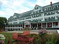
Eagle Mountain House
The Eagle Mountain House is a large historic hotel in Jackson, New Hampshire. It was added to the National Register in 1990. This grand hotel shows the history of tourism in New Hampshire. People would come here to enjoy the beautiful mountain scenery.
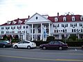
Eastern Slope Inn
Another historic inn is the Eastern Slope Inn in North Conway, New Hampshire. It was listed in 1982. Like the Eagle Mountain House, this inn tells the story of how people vacationed and enjoyed the White Mountains.
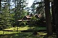
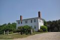
Joy Farm
Joy Farm in Madison, New Hampshire, is a very special place. It was listed as a National Historic Landmark in 1971. This farm was the home of the famous poet E. E. Cummings. It's important because of its connection to such a well-known American writer.
Libby Museum
The Libby Museum is located in Wolfeboro, New Hampshire. It became a historic site in 1998. Museums are places where we keep and display important items from the past. This museum helps preserve and share local history.
Moultonborough Town House
The Moultonborough Town House in Moultonborough, New Hampshire, was listed in 1989. It is now a local history museum. Town houses were often the center of local government and community meetings. This building continues to tell the story of the town.
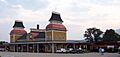
North Conway Depot and Railroad Yard
The North Conway Depot and Railroad Yard in North Conway, New Hampshire, is a historic district listed in 1979. A depot is a train station. This site shows the importance of railroads for travel and trade in the region's history.
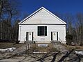
Russell-Colbath House
The Russell-Colbath House is on the Kancamagus Highway in Albany, New Hampshire. It was listed in 1987. This house is a great example of an old homestead. It gives us a peek into how early settlers lived in the more remote parts of New Hampshire.
St. John's Church, Rectory, and Parish Hall
In Wakefield, New Hampshire, the St. John's Church, Rectory, and Parish Hall became a historic site in 1984. Churches often play a central role in a community's social and spiritual life. These buildings show the history of faith and community in Wakefield.
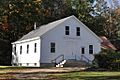
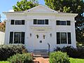
Town Hall (Sandwich, New Hampshire)
The Town Hall in Center Sandwich, New Hampshire, was listed in 1980. Like other town halls, this building was important for local government and community gatherings. It's a symbol of the town's civic history.
Wakefield Public Library
The Wakefield Public Library in Wakefield, New Hampshire, was added to the National Register in 1983. Libraries are vital for education and community connection. This building has served the people of Wakefield for many years.
Whittier Bridge
The Whittier Bridge is a historic bridge in West Ossipee, New Hampshire. It was listed in 1984. This bridge crosses the Bearcamp River. It's another example of important old structures that helped people travel and connect different areas.
Images for kids
-
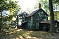
Abenaki Indian Shop and Camp
-
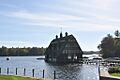
Bartlett Roundhouse
-
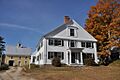
Beede Farm
-
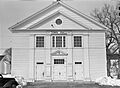
Brewster Memorial Hall
-
Brookfield Town Hall
-
Carroll County Court House
-
Center Sandwich Historic District
-
Chocorua Lake Basin Historic District
-
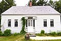
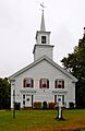
Cook Memorial Library
-
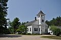
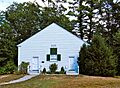
Cotton Mountain Community Church
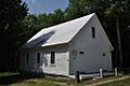
-
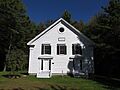
District No. 2 Schoolhouse
-
Durgin Bridge
-
Eagle Mountain House
-
Early Settlers Meeting House
-
Eastern Slope Inn
-
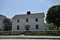
William K. Eastman House
-
First Free Will Baptist Church
-
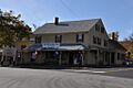
Freese's Tavern (Old Country Store)
-
Great Falls Manufacturing Company Newichawannock Canal Historic District
-
Hansen's Annex
-
Jackson Falls National Register Historic District
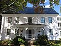
-
Bradbury Jewell House
-
Joy Farm
-
Libby Museum
-
Lord's Hill Historic District
-
Lower Corner Historic District
-
Madison School, District No. 1
-
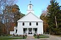
Moultonborough Town House
-
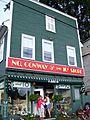
North Conway 5 and 10 Cent Store
-
North Conway Depot and Railroad Yard
-
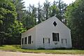
North Sandwich Meeting House
-
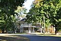
Pointfield
-
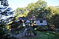
Pratt Family Camps
-
Capt. Enoch Remick House
-
Russell-Colbath House
-
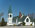
St. John's Church, Rectory, and Parish Hall
-
Swallow Boathouse
-
Town Hall
-
Tuftonboro United Methodist Church
-
Union Church
-
Union Hotel
-
Wakefield House
-
Wakefield Public Library
-
Wakefield Town Hall and Opera House
-
Wakefield Village Historic District
-
White Meetinghouse
-
Whittier Bridge
-
Windermere
-
Wolfeboro Centre Community Church


.jpg)


