
National Register of Historic Places listings in Garfield County, Colorado facts for kids

Did you know that many special buildings and places in Garfield County, Colorado are protected because of their history? These places are listed on the National Register of Historic Places. It's like a special list kept by the United States government. It helps make sure these important spots are saved for future generations to enjoy and learn from.
In Garfield County, there are 20 different places on this list. They include old schools, historic homes, bridges, and even a power plant! Each one tells a unique story about what life was like in Colorado long ago. Let's explore some of these amazing historic sites!
| Adams - Alamosa - Arapahoe - Archuleta - Baca - Bent - Boulder - Broomfield - Chaffee - Cheyenne - Clear Creek - Conejos - Costilla - Crowley - Custer - Delta - Denver - Dolores - Douglas - Eagle - El Paso - Elbert - Fremont - Garfield - Gilpin - Grand - Gunnison - Hinsdale - Huerfano - Jackson - Jefferson - Kiowa - Kit Carson - La Plata - Lake - Larimer - Las Animas - Lincoln - Logan - Mesa - Mineral - Moffat - Montezuma - Montrose - Morgan - Otero - Ouray - Park - Phillips - Pitkin - Prowers - Pueblo - Rio Blanco - Rio Grande - Routt - Saguache - San Juan - San Miguel - Sedgwick - Summit - Teller - Washington - Weld - Yuma |
Historic Buildings and Schools
Many of the places on the National Register in Garfield County are old buildings. They show us how people lived, learned, and worked in the past.
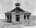
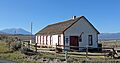
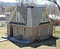
Battlement Mesa Schoolhouse
The Battlement Mesa Schoolhouse was built in 1903. It's located in Battlement Mesa, Colorado. This old schoolhouse is a great example of early education in the area. Imagine what it was like to go to school here over 100 years ago! It was added to the list in 1983.
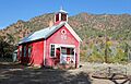
Canyon Creek School, District No. 32
Another historic school is the Canyon Creek School. It's near Glenwood Springs, Colorado. This school, built in 1909, served students in a rural area. It shows how important education was, even in smaller communities. It joined the National Register in 2004.
Missouri Heights School
The Missouri Heights School is located near Carbondale, Colorado. It was built in 1900. This school also played a big part in educating children in its community. It was added to the list in 1999.
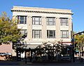
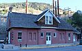
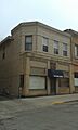
Citizens National Bank Building
In downtown Glenwood Springs, Colorado, you can find the Citizens National Bank Building. This impressive building was constructed in 1903. It shows the growth and importance of banking in the early 1900s. It became a historic place in 1999.
John Herbert Nunns House
The John Herbert Nunns House is in Silt, Colorado. This home was built in 1910. It is a good example of the types of houses people lived in during that time. It was added to the National Register in 2013.
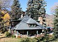
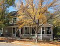
Starr Manor
Starr Manor is a beautiful historic home in Glenwood Springs, Colorado. It was built in 1891. This house shows the fancy architecture of the late 1800s. It was recognized as historic in 1986.
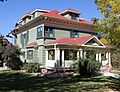
Edward T. Taylor House
Also in Glenwood Springs, Colorado, is the Edward T. Taylor House. This house was built in 1891. Edward T. Taylor was an important person in Colorado's history. His home became a historic site in 1986.
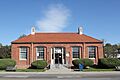
US Post Office-Rifle Main
The main post office in Rifle, Colorado is also a historic building. It was built in 1918. This building has served the community for over a century. It was added to the list in 1986.
Industrial and Infrastructure Sites
Garfield County's history also includes important industrial and engineering achievements. These sites helped the region grow.
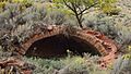
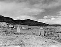
Cardiff Coke Ovens
The Cardiff Coke Ovens are located south of Glenwood Springs, Colorado. These ovens were built around 1890. They were used to turn coal into coke, which was important for making steel. They are a reminder of the area's mining past. They were listed in 1996.
Glenwood Springs Hydroelectric Plant
The Glenwood Springs Hydroelectric Plant was built in 1888. It's one of the oldest hydroelectric power plants in the United States. It used the power of water to create electricity. This plant helped bring modern power to the area. It became historic in 1998.
Havemeyer-Willcox Canal Pumphouse and Forebay
West of Rifle, Colorado, you can find the Havemeyer-Willcox Canal Pumphouse and Forebay. This system was built in 1908. It was important for bringing water to farms in the area. It shows early efforts in irrigation. It was listed in 1980.
Historic Bridges
Several old bridges in Garfield County are on the National Register. These bridges helped people and goods move across rivers and canyons.
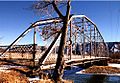
Rifle Bridge
The Rifle Bridge crosses the Colorado River near Rifle, Colorado. It was built in 1909. This bridge was a vital link for transportation. It was added to the list in 1985.
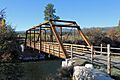
Satank Bridge
The Satank Bridge is near Carbondale, Colorado. This bridge was built in 1910. It helped connect communities across the river. It became a historic site in 1985.
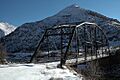
South Canon Bridge
The South Canon Bridge is located near Glenwood Springs, Colorado. It was built in 1909. Like the other bridges, it played a key role in local travel. It was listed in 1985.
Other Notable Historic Places
Garfield County has other unique historic sites that tell different parts of its story.
Earnest Ranch
The Earnest Ranch is near Glenwood Springs, Colorado. This ranch was established in 1883. It represents the long history of ranching and farming in the region. It was added to the list in 1998.
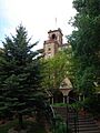
Hotel Colorado
The Hotel Colorado in Glenwood Springs, Colorado is a very famous landmark. It was built in 1893. Many important people have stayed here over the years. It's known for its grand style and history. It became a historic place in 1977.
Holland-Thompson Property
The Holland-Thompson Property is near Carbondale, Colorado. It was listed in 2013.
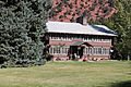
Sumers Lodge
Sumers Lodge is in Glenwood Springs, Colorado. It was built in 1905. This lodge is a great example of early mountain resort architecture. It was added to the list in 1997.
Wasson-McKay Place
The Wasson-McKay Place is located in Parachute, Colorado. It was listed in 2010.
Western Hotel
The Western Hotel in Glenwood Springs, Colorado was built in 1890. It's another important historic hotel in the area. It became a historic site in 2016.
Images for kids
-
Battlement Mesa Schoolhouse
-
Canyon Creek School, District No. 32
-
Cardiff Coke Ovens
-
Citizens National Bank Building
-
Earnest Ranch
-
Glenwood Springs Hydroelectric Plant
-
Havemeyer-Willcox Canal Pumphouse and Forebay
-
Hotel Colorado
-
Missouri Heights School
-
Rifle Bridge
-
Satank Bridge
-
South Canon Bridge
-
Starr Manor
-
Sumers Lodge
-
Edward T. Taylor House
-
US Post Office-Rifle Main
-
Wasson-McKay Place
-
Western Hotel


