
National Register of Historic Places listings in Las Animas County, Colorado facts for kids

Welcome to Las Animas County, Colorado! This area is full of amazing places that are super important to history. This article will tell you all about the special buildings and sites in Las Animas County that are listed on the National Register of Historic Places.
The National Register of Historic Places is like a special list kept by the United States government. It includes buildings, places, and even whole neighborhoods that are important because of their history, architecture, or what happened there. When a place is on this list, it means it's recognized as a valuable part of our country's past and should be protected.
In Las Animas County, there are 37 different places on this list! Some are old schools, some are historic homes, and others are important landmarks. Let's explore some of these cool spots!
Historic Schools in Las Animas County
Las Animas County has several old school buildings that are now historic landmarks. These schools tell us a lot about how kids learned in the past.
Country Schools
Many schools in the county were small, one-room schoolhouses where children from different grades learned together.
- The 7-D School near Branson was added to the list in 2009. Imagine all the kids learning their ABCs and math in one room!
- The Pleasant Valley School, also near Branson, became historic in 2008. It's another example of a classic country school.
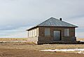
- The White School near Kim was listed in 2008. These schools were often the center of their communities.
- The Earl School near Earl was recognized in 2013. It's part of a larger group of rural school buildings in Colorado that are being preserved.
Town Schools
Larger towns also have their historic schools.
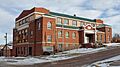
- The East Street School in Trinidad was built to serve the growing number of students in the city. It was added to the Register in 2007.
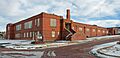
- The Kim Schools in Kim are a historic district, meaning a group of buildings that are important together. They were listed in 2007.
Important Homes and Buildings
Many old houses and public buildings in Las Animas County show us how people lived and worked long ago.
Trinidad's Historic Homes
The city of Trinidad has many beautiful old homes that are on the National Register.
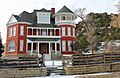
- The Aultman House (listed 2007) is one example of the lovely architecture from the past.
- The Baca House and Outbuilding (listed 1970) is a very old home that gives us a peek into life in the late 1800s. It's part of a museum today.
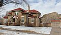
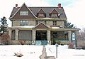
- Right next door is the Frank G. Bloom House (listed 1970). Frank Bloom was an important banker in Trinidad, and his grand house shows how successful people lived.
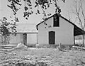
- The Charles Emerick House (listed 2014) and the McCormick House (listed 2009) are other examples of historic homes in Trinidad.
- The Frank Latuda House (listed 2010) and the Nichols House (listed 2005) also add to the city's rich history.
- The Margarito Varras Homestead near Kim (listed 2014) is a historic farm or ranch site, showing how families settled and lived off the land.
Public and Community Buildings
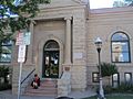
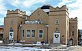
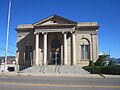
- The Carnegie Public Library in Trinidad (listed 1995) is a beautiful building that was funded by Andrew Carnegie, a famous businessman who helped build many libraries across the country.
- The Jaffa Opera House in Trinidad (listed 1972) was once a lively place for performances and community events.
- The US Post Office-Trinidad Main (listed 1986) is where people have sent and received mail for many years. It's an important part of the city's services.
Historic Districts and Landmarks
Some places are important not just for one building, but for a whole area or a natural feature.
Historic Districts
- The Cokedale Historic District (listed 1985) is a whole town that was built around a coal mining operation. It shows what life was like in a company town.
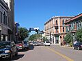
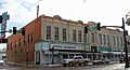
- The Corazon de Trinidad (listed 1973) is a large historic district in downtown Trinidad. "Corazon" means "heart" in Spanish, and this area is truly the heart of the city, with many old shops and buildings.
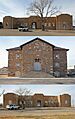
- The Rourke Ranch Historic District (listed 2000) is a historic ranch located in the Comanche National Grassland. It shows how ranching was done in the past.
Important Sites and Landmarks
- The Colorado Millennial Site (listed 1980) is an archaeological site that tells us about ancient people who lived in this area thousands of years ago.
- The Ludlow Tent Colony Site (listed 1985) is a very important place in Colorado history. It was the site of the Ludlow Massacre, a tragic event in 1914 where striking coal miners and their families were attacked. It's now a National Historic Landmark, which is an even higher level of historical importance.
- Raton Pass (listed 1966) is a mountain pass that was a key route for travelers and traders on the Santa Fe Trail. It's on the border between Colorado and New Mexico and was also declared a National Historic Landmark.
- The Santa Fe Trail Mountain Route Trail Segments near Delhi (listed 2015) are parts of the famous Santa Fe Trail, an important trade route in the 1800s. These segments show where wagons and travelers once passed.
- The Torres Cave Archeological Site (listed 1980) and the Trinchera Cave Archeological District (listed 2001) are places where archaeologists have found evidence of ancient human life, helping us understand the very first people who lived in this region.
- The Monument Lake Park Building and Hatchery Complex (listed 2014) near Weston is a historic park area with buildings related to fishing and outdoor recreation.
Churches and Bridges
Las Animas County also has historic churches and bridges.
Historic Churches
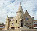
- The First Baptist Church (listed 2000), First Christian Church (listed 1995), and First Methodist Episcopal Church (listed 2005) are all historic places of worship in Trinidad.
- Zion's German Lutheran Church (listed 2006) in Trinidad also has a long history, serving its community for many years.
Historic Bridges
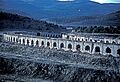
- The Bridge over Burro Canon (listed 1985) on State Highway 12 is an example of historic engineering.
Former Listings
Sometimes, places are removed from the National Register. This can happen if a building is changed too much, or if it's destroyed.
- The Avery Bridges near Aguilar and Hoehne were delisted in 2002.
- The Commercial Street Bridge in Trinidad was delisted in 1994 because it was replaced.
- The Elson Bridge near El Moro was also delisted in 2002.
These places, even if they are no longer on the list, still have their own stories and are part of the history of Las Animas County.
| Adams - Alamosa - Arapahoe - Archuleta - Baca - Bent - Boulder - Broomfield - Chaffee - Cheyenne - Clear Creek - Conejos - Costilla - Crowley - Custer - Delta - Denver - Dolores - Douglas - Eagle - El Paso - Elbert - Fremont - Garfield - Gilpin - Grand - Gunnison - Hinsdale - Huerfano - Jackson - Jefferson - Kiowa - Kit Carson - La Plata - Lake - Larimer - Las Animas - Lincoln - Logan - Mesa - Mineral - Moffat - Montezuma - Montrose - Morgan - Otero - Ouray - Park - Phillips - Pitkin - Prowers - Pueblo - Rio Blanco - Rio Grande - Routt - Saguache - San Juan - San Miguel - Sedgwick - Summit - Teller - Washington - Weld - Yuma |
Images for kids
-
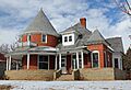
The Aultman House in Trinidad.
-
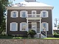
The Baca House in Trinidad.
-
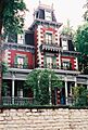
The Frank G. Bloom House in Trinidad.
-
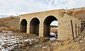
The historic Bridge over Burro Cañon.
-
The Carnegie Public Library in Trinidad.
-
A view of the Cokedale Historic District.
-
A street view in the Corazon de Trinidad Historic District.
-
The East Street School in Trinidad.
-
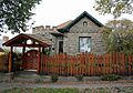
The Charles Emerick House in Trinidad.
-
The First Baptist Church in Trinidad.
-
The First Christian Church in Trinidad.
-
The First Methodist Episcopal Church in Trinidad.
-
The Jaffa Opera House in Trinidad.
-
The Kim Schools complex.
-
The Frank Latuda House in Trinidad.
-
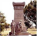
The monument at the Ludlow Tent Colony Site.
-
The McCormick House in Trinidad.
-
The Nichols House in Trinidad.
-
The Pleasant Valley School near Branson.
-
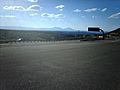
Raton Pass, a historic mountain pass.
-
A building at the Rourke Ranch Historic District.
-
The U.S. Post Office in Trinidad.
-
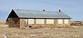
The White School near Kim.
-
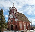
Zion's German Lutheran Church in Trinidad.
-
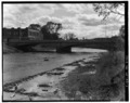
The former Commercial Street Bridge in Trinidad.
-
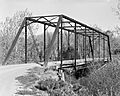
The former Elson Bridge.


.JPG)
.JPG)
.JPG)


.JPG)


.jpg)
