
National Register of Historic Places listings in Prowers County, Colorado facts for kids

Have you ever wondered about old buildings and places that are super important to history? In Prowers County, Colorado, there are many such spots! This article will tell you about the special places in Prowers County that are listed on the National Register of Historic Places. This list includes buildings, bridges, and even an entire farm! These places are protected because they tell important stories about the past of Colorado and the United States.
There are 16 amazing places in Prowers County that are on this list. One of them is even a National Historic Landmark, which means it's extra special and important to the whole country!
| Adams - Alamosa - Arapahoe - Archuleta - Baca - Bent - Boulder - Broomfield - Chaffee - Cheyenne - Clear Creek - Conejos - Costilla - Crowley - Custer - Delta - Denver - Dolores - Douglas - Eagle - El Paso - Elbert - Fremont - Garfield - Gilpin - Grand - Gunnison - Hinsdale - Huerfano - Jackson - Jefferson - Kiowa - Kit Carson - La Plata - Lake - Larimer - Las Animas - Lincoln - Logan - Mesa - Mineral - Moffat - Montezuma - Montrose - Morgan - Otero - Ouray - Park - Phillips - Pitkin - Prowers - Pueblo - Rio Blanco - Rio Grande - Routt - Saguache - San Juan - San Miguel - Sedgwick - Summit - Teller - Washington - Weld - Yuma |
Discovering Prowers County's Historic Treasures
Prowers County is home to many historic sites. These places help us understand what life was like long ago. From old hotels to important bridges and even a historic schoolhouse, each site has a unique story.
Historic Buildings in Lamar
Lamar, Colorado is the biggest city in Prowers County. It has several buildings on the National Register.
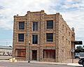
The Davies Hotel: A Glimpse into the Past
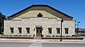
The Davies Hotel is located at 122 North Main Street in Lamar. It was added to the list in 1978. Imagine travelers staying here many years ago! Hotels like this were busy places where people rested and met others.

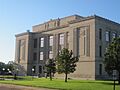
Prowers County Courthouse: A Center of Community
The Prowers County Building (also known as the Courthouse) is at 301 South Main Street. It was listed in 1981. This building is where important decisions for the county are made. Courthouses are often grand buildings that show the importance of local government.

Lamar's Main Post Office
The US Post Office-Lamar Main is found at 300 South 5th Street. It joined the list in 1986. Post offices were, and still are, vital for sending letters and packages. This building has served the community for a long time.

Prowers County Welfare Housing
At 800 East Maple Street in Lamar, you'll find the Prowers County Welfare Housing. It was added to the list in 2009. This building tells a story about how communities cared for people in need during different times in history.

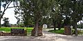
Willow Creek Park: A Place for Everyone
Willow Creek Park in Lamar is roughly bordered by Memorial Drive, Parkview Avenue, and Willow Valley Road. It became a historic district in 2007. Parks are important community spaces where people gather, play, and relax. This park has been a special place for Lamar residents for many years.

Historic Sites Near Granada
Granada, Colorado also has some very important historic places.
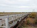
Douglas Crossing Bridge: Connecting Communities
The Douglas Crossing Bridge is on County Road 28 near Granada. It was listed in 1985. Bridges are crucial for travel and trade, helping people and goods cross rivers and valleys. This bridge has been a key link for the area.

Granada Bridge: Another Important Crossing
Another bridge, the Granada Bridge, is on U.S. Route 385 near Granada. It was added to the list in 2002. Like the Douglas Crossing Bridge, it shows the importance of transportation in the region's history.
.JPG)
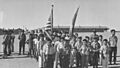
Granada Relocation Center: A National Historic Landmark
One of the most important sites in Prowers County is the Granada Relocation Center, also known as Amache. It's located about one mile southwest of Granada. This site became a National Historic Landmark in 1994. During World War II, this was one of ten camps where Japanese Americans were forced to live. It's a very important place to remember a difficult time in American history and to learn about civil rights.

Historic Places in Holly
The town of Holly, Colorado also has its share of historic buildings.
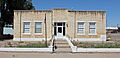
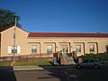
Holly City Hall: The Heart of Town
The Holly City Hall is at 119 East Cheyenne Street. It was listed in 2003. City halls are where local government operates and where many community events take place.

Holly Gymnasium: A Place for Sports and Fun
The Holly Gymnasium on North Main Street was added to the list in 2007. Gymnasiums are places for sports, school events, and community gatherings. This building likely holds many memories for the people of Holly.

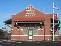
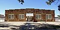
Holly Santa Fe Depot: A Stop on the Railroad
The Holly Santa Fe Depot is at 302 South Main Street. It became historic in 1995. Train depots were once bustling hubs where people arrived and departed, and goods were shipped. They played a huge role in connecting towns.

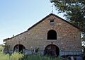
Holly SS Ranch Barn: A Piece of Farm History
The Holly SS Ranch Barn is at 407 West Vinson. It was listed in 2004. Barns are important parts of farm life, used for storing crops and housing animals. This barn shows the agricultural history of the area.

Wiley Rock Schoolhouse: Learning Through the Years
In Wiley, Colorado, you'll find the Wiley Rock Schoolhouse at 603 Main Street. It was added to the list in 2004. Schoolhouses are special places where generations of children learned and grew. This building represents the history of education in Wiley.

Other Notable Historic Sites
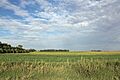
Paulsen Farm: A Historic Farmstead
The Paulsen Farm is located at 39035 Road 7 near Lamar. It became a historic district in 1999. Farms are essential to our food supply and represent the hard work of generations of farmers. This farm shows the agricultural heritage of Prowers County.

Petticrew Stage Stop: A Stop on the Old Trails
The Petticrew Stage Stop is also near Lamar. It was listed in 2000. Stage stops were places where stagecoaches would stop for travelers to rest, eat, and change horses. They were like early motels and restaurants on the long journeys across the country.
Images for kids
-
Davies Hotel
-

Douglas Crossing Bridge
-
Granada Bridge
-
Granada Relocation Center
-
Holly City Hall
-
Holly Gymnasium
-
Holly Santa Fe Depot
-
Holly SS Ranch Barn
-
Paulsen Farm
-
Prowers County Courthouse
-

Prowers County Welfare Housing
-
US Post Office-Lamar Main
-
Wiley Rock Schoolhouse
-
Willow Creek Park
