
Block Island facts for kids
Quick facts for kids
New Shoreham, Rhode Island
Block Island
|
||
|---|---|---|
|
Town
|
||

Block Island looking north over Block Island Sound. The coast of Rhode Island is seen in the distance.
|
||
|
||
| Nickname(s):
Manisses, meaning Manitou's Little Island (used by Narragansett people)
|
||

Location of New Shoreham in Washington County, Rhode Island
|
||
| Country | United States | |
| State | Rhode Island | |
| County | Washington | |
| Government | ||
| • Type | Council-manager | |
| Area | ||
| • Land | 9.73 sq mi (25.2 km2) | |
| Elevation | 13 ft (4 m) | |
| Population
(2020)
|
||
| • Total | 1,410 | |
| Time zone | UTC−5 (EST) | |
| • Summer (DST) | UTC−4 (EDT) | |
| ZIP Code |
02807
|
|
| Area code(s) | 401 | |

| Historical population | |||
|---|---|---|---|
| Census | Pop. | %± | |
| 1970 | 489 | — | |
| 1980 | 620 | 26.8% | |
| 1990 | 836 | 34.8% | |
| 2000 | 1,010 | 20.8% | |
| 2010 | 1,051 | 4.1% | |
| 2020 | 1,410 | 34.2% | |
Block Island is an island located about 9 miles (14 km) south of mainland Rhode Island. It is also about 14 miles (23 km) east of Montauk Point on Long Island. The island is the same area as the town of New Shoreham, Rhode Island. It is part of Washington County. The island is named after the Dutch explorer Adriaen Block. The town was named after Shoreham, Kent, in England.
Block Island is a popular place for summer tourists. People enjoy bicycling, hiking, sailing, fishing, and visiting the beaches. It has two old lighthouses: Block Island North Light and Block Island Southeast Light. About 40 percent of the island is protected land. This means it is kept natural and undeveloped. The northwestern part of the island is a natural area. It is a resting stop for birds flying along the Atlantic flyway. The Nature Conservancy calls Block Island one of "The Last Great Places." This list includes 12 special sites in the Western Hemisphere.
Fun events happen every year, like the Fourth of July Parade and fireworks. The island's population can become three times larger during the summer. In 2020, the island had 1,410 people living on about 9.734 square miles (25.21 km²) of land.
Island History: Exploring Block Island's Past
Early Inhabitants: The Niantic People
The Niantic Indians called the island "Manisses." This name means "Manitou's Little Island" or simply "Little Island." They lived by hunting deer, catching fish and shellfish, and growing crops. These crops included corn, beans, and squash. They likely used a method called the Three Sisters for farming.
Archaeological finds show that Native Americans might have visited the island as early as 8000 BC. They may have lived there permanently since 500 AD. At one point, up to 600 people lived on the island.
European Explorers Arrive
In 1524, Giovanni da Verrazzano saw the island. He named it "Claudia" after Claude, the Queen of France. However, some maps from that time called it "Luisa." This was after Louise of Savoy, the Queen Mother of France. Verrazzano's ship log said the island was "full of hilles, covered with trees, well-peopled for we saw fires all along the coaste." In 1614, the Dutch explorer Adriaen Block mapped the island. He named it after himself.
Pequot War and Settlers

Tensions grew between different Native American tribes. The Niantic people split into two groups. The Western Niantics joined with the Pequots and Mohegans. The Eastern Niantics allied with the Narragansetts.
In 1632, some Native Americans killed English traders John Stone and Walter Norton. The Pequots were blamed. In 1636, a trader named John Oldham was killed. His boat was found near Block Island.

The Massachusetts Bay Colony sent 90 men to Block Island. Their leader was John Endecott. They were told to punish the Niantics for Oldham's death. The English burned 60 Native American homes and corn fields. They also shot many dogs. The Niantics hid in the woods, and the soldiers killed 14 of them. These events helped start the Pequot War.
After the war, Massachusetts Bay Colony claimed the island. In 1658, they sold it to a group led by Endecott. In 1661, this group sold the island to 16 new settlers. These settlers are remembered at Settler's Rock. In 1663, some land was given to four Native American leaders. This land was called the Indian Lands. In 1664, about 1,200 to 1,500 Native Americans lived on the island. By 1774, this number had dropped to 51. A Dutch map from 1685 clearly shows Block Island.
In 1699, the Scottish sailor William Kidd visited Block Island. He was given supplies by Mercy (Sands) Raymond. The story says that Kidd gave Mrs. Raymond gold and jewels. This made her family very wealthy.
Block Island Since Colonial Times

The new settlers became part of Rhode Island. Block Island officially became a town in 1672. The island government chose the name "New Shoreham."

During the War of 1812, the British Navy briefly took over Block Island. They were led by Sir Thomas Hardy. The British wanted food and a good spot near Long Island Sound. But the islanders had moved all their food and animals to Stonington, Connecticut. On August 9, 1814, Hardy and his ships left Block Island for Stonington. They wanted to get the food back. But their attack on August 10 was stopped. This battle is known as The Battle of Stonington.
The first North Lighthouse was built in 1829. But it was washed away by the sea. A new one was built in 1837, but it also disappeared. The lighthouse you see today was built in 1867. Construction on Block Island's Southeast Lighthouse began in 1873.
Block Island did not have natural harbors. So, walls called breakwaters were built in 1870 to create Old Harbor. New Harbor was made in 1895. A channel was dug to connect the Great Salt Pond to the ocean.
The Island Free Library, the only public library, opened in 1875.
In 1886, Isaac Church, the last full-blooded Manisses Indian, died at age 100. His descendants still live in Rhode Island. Isaac's Corner is a landmark named after him. It is located where Center Road, Lakeside Drive, and Cooneymus Road meet. Isaac is buried in the Historical Indian Burial Ground. In 2011, the Block Island Historical Society honored the Manisses Indians.
The island was hit hard by the 1938 New England hurricane. Many people lost their lives during the storm.
During World War II, observers were placed on the island. They helped direct gunfire from Fort Greene in Point Judith. These guns protected Narragansett Bay. The US government offered to move islanders away. But the islanders chose to stay. Days before the war ended, the Battle of Point Judith happened near the island.
The island's airport opened in 1950. It is still used today for small planes. In 1972, the Block Island Conservancy was started. This group and others protect over 40% of the island from building. In 1974, the Old Harbor Historic District became a historic district.
Island Weather: Block Island's Climate
Block Island's weather is greatly affected by the ocean and winds. The climate is called oceanic. This is rare for an east coast in the Northern Hemisphere. The ocean stays cold in spring and summer. This keeps Block Island cooler than the mainland during these seasons. Summers are also cooler. July and August average in the 70s°F (20s°C) instead of the 80s°F (20s-30s°C) seen on the mainland.
The highest temperature ever recorded on Block Island was 95°F (35°C). This happened on August 26 and 27, 1948. The lowest temperature ever was -7°F (-22°C) on January 16, 1994. Block Island stays warmer than the mainland in fall and winter. This is because the ocean stays warmer than the land.
Island Life: People and Culture
Island Population: Demographics
In 2000, there were 1,010 people living on Block Island. By 2020, the population grew to 1,410. This makes it the least populated town in Rhode Island. Most of the people living there are White.
Fun Events: Annual Celebrations
One of the most popular events is the Fourth of July Parade. Anyone can enter a float, as long as it matches the year's theme. For example, in 2016, the theme was sports and recreation. On July 3, there are fireworks on the beach. The parade happens on the fourth. Judges give prizes for family floats, company floats, and overall floats. There is also a grand prize of $500.
Every summer, the island hosts Block Island Race Week. This is a week-long sailboat race. Yachts compete in different groups. They sail around Block Island Sound and the island itself.
The Block Island Film Festival is also held every year. It started in 2018. It shows independent movies from local and international filmmakers. These include motion pictures, documentaries, and short films.
Block Island Pride is an annual celebration. It supports the LGBTQ+ community. It includes parades, live shows, and workshops. It helps make the island a welcoming place for everyone.
Places to Visit: Tourist Attractions

The Southeast Lighthouse is on the southeast corner of the island. It was built in 1875. It is still used by the United States Coast Guard to guide ships. The lighthouse was moved in 1993 because it was in danger of falling off the cliffs. You can tour the tower. There is also a museum open in the summer.
The Mohegan Bluffs are clay cliffs near the Southeast Lighthouse. They were the site of an old battle. The invading Mohegan tribe was pushed off the cliffs by the native Niantic. A staircase with 141 steps leads to the bottom of the cliffs. From there, you can see the Atlantic Ocean. On clear days, you can see Montauk, New York, in the distance.

Rodman's Hollow is a 230-acre (93 ha) area near the southern shore. It was formed by glaciers. It has several walking trails.
The North Lighthouse is at Sandy Point. This is on the northern tip of Block Island. It warns boaters about a sandbar. The sand dunes around it are part of the Block Island National Wildlife Refuge. Many animals live here, like the piping plover and American burying beetle. A short walk from the North Lighthouse is the very tip of the island. It is a thin strip of land with ocean on both sides.
The Block Island Historical Society Museum is near the main town area. It has many old items from Block Island.
The U-853 is a U-boat shipwreck. It is 7 miles (11 km) east of the island. It lies in 130 feet (40 m) of water. Divers often visit the wreck.
The Block Island Wind Farm is the first offshore wind farm in the United States. It is 3 miles (4.8 km) southeast of the island.

The five tall turbines started working in December 2016.
The island has at least 40 restaurants. Most of them close outside of the tourist season. Mainland restaurants use New England Airlines to deliver food to the island.
Outdoor Fun: Parks and Recreation


Block Island has 17 miles (27 km) of beaches. Crescent Beach can be seen from the ferries. It has five smaller beaches:
- Fred Benson Town Beach (also called State Beach)
- Surf Beach
- Scotch Beach
- Rouse's Beach
- Mansion Beach
All these beaches are on Corn Neck Road. North of Mansion Beach are Clayhead and Pots & Kettles. Clayhead has cliffs that can be seen from the ferry. This area is rocky and has iron-rich clay. It is a popular spot for finding shells and rocks.
Cow Cove, Settler's Rock, and Sandy Point are at the northernmost part of Block Island. This is where the North Lighthouse is. Settler's Rock is at Cow Cove. This is where the first settlers landed. They pushed the island's first cows off the boats and made them swim to shore. A plaque on the rock lists the names of the original settlers. Coastguard Beach is between the Great Salt Pond and the ocean. Ballard's Beach is south of the Block Island Ferry Dock. Bluffs Beach is at the bottom of Mohegan Bluffs.
Block Island also has an office for The Nature Conservancy. This group named Block Island one of its top 12 sites in the Western Hemisphere. A large part of the island is protected. This means it is kept natural and undeveloped.
Island Economy: Industry
The island is known for its commercial aquaculture. This is farming seafood like fish and shellfish. It also participates in kelp farming.
Getting Around: Transportation


You can reach the island by ferry all year from Point Judith. In summer, ferries also come from:
The regular ferry from Point Judith takes about an hour. It is the only way to bring a car to the island. A faster ferry on the same route takes 35 minutes but cannot carry cars. Another fast ferry from New London takes just over an hour.
Bikes are a popular way to get around the island. Cars are generally not encouraged. Mopeds are also very popular, especially with tourists. They are easy to rent and drive. There are over six moped rental shops. However, moped accidents are a common problem on the island.
New England Airlines offers short 12-minute flights. They fly to Block Island State Airport from Westerly, Rhode Island. The island airport is called Block Island State (code: BID). The airport building is about one mile from the town center.
Island Events: Incidents and Shipwrecks
Air Crashes
On August 26, 1995, a small seaplane crashed. It was trying to land near Old Harbor Beach. The plane hit a power line. It then crashed into a restaurant and a car at the island's only gas station. All four people on the plane died. A woman sitting in her car also died. The restaurant was destroyed by the crash and fire.
On July 5, 2006, another plane crashed. It was carrying three people. The crash happened near the airport during bad weather. The plane had just taken off and was going to White Plains, New York.
Shipwrecks Around Block Island
Many ships have sunk near Block Island. These include:
- The Steamer Larchmont in 1907.
- The Princess Augusta (also called the Palatine ship) in 1738. This wreck was written about in a poem by John Greenleaf Whittier.
- The freighter Achilles in 1877. It hit a rock and got stuck.
- The Cunard liner Queen Elizabeth 2 in 1992. It also hit a submerged rock.
Two submarines also sank off Block Island:
- USS S-51 in 1925.
- German submarine U-853 in 1945.
Famous Faces: Notable People
- Kenneth Bacon (1944–2009), a spokesman for the Department of Defense.
- Tad Devine (born 1955), a political advisor who worked on presidential campaigns.
- Elizabeth Dickens (1877–1963), known as "the Bird Lady of Block Island," a writer and naturalist.
- Richard Parsons (born 1948), a business executive who led companies like Citigroup and Time Warner.
- Jens Risom (1916–2016), a furniture designer from Denmark and America.
- William Stringfellow (1928–1985), an attorney and religious writer.
Images for kids
-
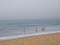
Swimmers in smooth waters at Block Island
-
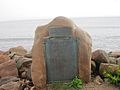
Settler's Rock is the most northerly part of Block Island accessible to motorists
-
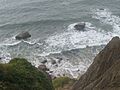
Steep bluffs at Block Island
-
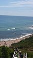
View of the Atlantic Ocean from a cliff on Block Island
-

This house was formerly the US Weather Bureau Station on Block Island
-
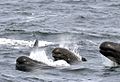
Long-finned Pilot Whales off southeast of Block Island


_(6892801246).jpg)
| Climate data for Block Island, Rhode Island | |||||||||||||
|---|---|---|---|---|---|---|---|---|---|---|---|---|---|
| Month | Jan | Feb | Mar | Apr | May | Jun | Jul | Aug | Sep | Oct | Nov | Dec | Year |
| Record high °F (°C) | 62 (17) |
62 (17) |
74 (23) |
92 (33) |
85 (29) |
90 (32) |
92 (33) |
95 (35) |
89 (32) |
80 (27) |
72 (22) |
64 (18) |
95 (35) |
| Mean daily maximum °F (°C) | 39.8 (4.3) |
40.9 (4.9) |
45.6 (7.6) |
54.6 (12.6) |
63.2 (17.3) |
73.0 (22.8) |
77.9 (25.5) |
77.6 (25.3) |
72.6 (22.6) |
63.0 (17.2) |
54.3 (12.4) |
45.2 (7.3) |
59.0 (15.0) |
| Mean daily minimum °F (°C) | 25.4 (−3.7) |
26.6 (−3.0) |
30.7 (−0.7) |
38.8 (3.8) |
47.1 (8.4) |
56.5 (13.6) |
62.5 (16.9) |
62.4 (16.9) |
56.9 (13.8) |
48.1 (8.9) |
40.5 (4.7) |
30.0 (−1.1) |
43.8 (6.6) |
| Record low °F (°C) | −7 (−22) |
−6 (−21) |
7 (−14) |
18 (−8) |
34 (1) |
41 (5) |
51 (11) |
45 (7) |
39 (4) |
30 (−1) |
16 (−9) |
−4 (−20) |
−7 (−22) |
| Average precipitation inches (mm) | 3.87 (98) |
2.93 (74) |
4.07 (103) |
3.79 (96) |
3.46 (88) |
3.78 (96) |
2.86 (73) |
2.95 (75) |
3.39 (86) |
3.91 (99) |
3.81 (97) |
3.78 (96) |
42.60 (1,082) |
| Average snowfall inches (cm) | 6.1 (15) |
6.3 (16) |
5.4 (14) |
0.4 (1.0) |
0 (0) |
0 (0) |
0 (0) |
0 (0) |
0 (0) |
0 (0) |
0.2 (0.51) |
2.8 (7.1) |
21.1 (54) |
| Average precipitation days (≥ 0.01 in) | 7.9 | 7.7 | 9.7 | 9.9 | 9.8 | 7.4 | 6.2 | 6.2 | 6.5 | 7.9 | 8.8 | 9.1 | 97.1 |
| Source 1: NOAA (normals, 1981–2010) | |||||||||||||
| Source 2: Western Regional Climate Center (extremes 1927–present) | |||||||||||||
See also
 In Spanish: Block Island para niños
