Northumberland, New York facts for kids
Quick facts for kids
Northumberland
|
|
|---|---|
| Town of Northumberland | |

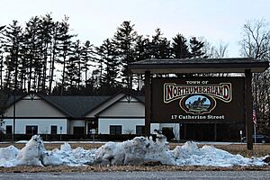
Town hall
|
|

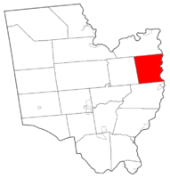
Map highlighting Northumberland's location within Saratoga County.
|
|
| Country | United States |
| State | New York |
| County | Saratoga |
| Named for | Northumberland, England |
| Area | |
| • Total | 32.92 sq mi (85.26 km2) |
| • Land | 32.30 sq mi (83.65 km2) |
| • Water | 0.62 sq mi (1.60 km2) |
| Elevation | 282 ft (86 m) |
| Population
(2020)
|
|
| • Total | 5,242 |
| • Density | 159.23/sq mi (61.483/km2) |
| Time zone | UTC-5 (Eastern (EST)) |
| • Summer (DST) | UTC-4 (EDT) |
| ZIP code |
12831, 12866, 12871
|
| Area code(s) | 518 |
| FIPS code | 36-53737 |
| GNIS feature ID | 0979294 |
Northumberland is a small town in Saratoga County, New York, United States. It is located just north of Schuylerville and northeast of Saratoga Springs. The town also sits on the west bank of the Hudson River.
Contents
Where Did the Name Northumberland Come From?
The town's name, Northumberland, comes from Northumberland, a county in the United Kingdom. It's like naming a new place after a special place you remember!
A Look Back: Northumberland's History
The first settlers arrived in the Northumberland area around 1765. Before that, the land was home to the Mohican Native Americans. They had two villages within what is now the town.
Northumberland During the American Revolution
During the Battle of Saratoga, a major event in the American Revolution, the British army led by General Burgoyne crossed the Hudson River in Northumberland. This crossing happened at a spot where Hudson Crossing Park is now located. After crossing, Burgoyne's army marched south, hoping to capture Albany.
How the Town Was Formed
The town of Northumberland was officially created in 1798. It was formed from a larger area called the Town of Saratoga. Over time, some parts of Northumberland were used to create new towns. These included Hadley in 1801, Moreau in 1805, and Wilton in 1818.
Important Developments and Landmarks
The Champlain Canal, an important waterway, officially opened in 1823. This canal helped move goods and people. Later, in 2003, the Col. Sidney Berry House was added to the National Register of Historic Places. This means it's a special building recognized for its history.
Famous People Connected to Northumberland
Northumberland has been home to or visited by some interesting people:
- Herman Melville: This famous author, known for writing Moby Dick, often visited his mother, Maria Gansevoort Melville. She lived in Northumberland.
- Peter Gansevoort: A brave commander during the American Revolution. He led the defense of Fort Stanwix when it was under attack.
Exploring Northumberland's Geography
Northumberland covers about 32.9 square miles (85 km2) of land and water. Most of it, about 32.3 square miles (84 km2), is land. The rest, about 0.6 square miles (1.6 km2), is water.
Rivers and Roads
The eastern edge of the town is marked by the Hudson River. This river also forms the border with Washington County.
Several important roads run through Northumberland:
- U.S. Route 4: This highway runs north and south along the Hudson River in the southeastern part of town.
- New York State Route 32: Another north-south highway that meets New York State Route 50 in the community of Gansevoort. Parts of US-4 and NY-32 actually share the same road in Northumberland.
Land and Water Features
Northumberland is located in the northern part of the Hudson Valley. The land here has small creeks and hills. The Snook Kill River flows through the northern part of the town. The main community, Gansevoort, is found in the northern section of Northumberland.
Northumberland's Population Over Time
| Historical population | |||
|---|---|---|---|
| Census | Pop. | %± | |
| 1820 | 1,279 | — | |
| 1830 | 1,606 | 25.6% | |
| 1840 | 1,672 | 4.1% | |
| 1850 | 1,775 | 6.2% | |
| 1860 | 1,666 | −6.1% | |
| 1870 | 1,655 | −0.7% | |
| 1880 | 1,583 | −4.4% | |
| 1890 | 1,410 | −10.9% | |
| 1900 | 1,227 | −13.0% | |
| 1910 | 1,127 | −8.1% | |
| 1920 | 1,048 | −7.0% | |
| 1930 | 1,059 | 1.0% | |
| 1940 | 1,109 | 4.7% | |
| 1950 | 1,263 | 13.9% | |
| 1960 | 1,353 | 7.1% | |
| 1970 | 1,779 | 31.5% | |
| 1980 | 2,732 | 53.6% | |
| 1990 | 3,645 | 33.4% | |
| 2000 | 4,603 | 26.3% | |
| 2010 | 5,087 | 10.5% | |
| 2020 | 5,242 | 3.0% | |
| U.S. Decennial Census | |||
In 2000, about 4,603 people lived in Northumberland. By 2020, the population had grown to 5,242 people. The town has a mix of families and individuals. Many households have children under 18 living there. The average age in the town in 2000 was 34 years old.
Communities and Places in Northumberland
Northumberland has several smaller communities and interesting spots:
- Bacon Hill: A small village northwest of the main Northumberland village. It was named after an early settler, Ebenezer Bacon. Before that, it had fun names like "Fiddletown" and "Popes Corners."
- Callahans Corners: A village located near the center of the town on NY-32, south of Jewell Corner.
- Gansevoort: A village in the northern part of the town, also on NY-32. It's named after the famous Peter Gansevoort.
- Griffin Island: An island in the Hudson River, found in the northeastern part of the town.
- Jewell Corner: A village southeast of Gansevoort on NY-32.
- Northumberland: This is the main village of the town. It's located where US-4 and NY-32 meet, right by the Hudson River.
- Starks Knob: A village south of the Northumberland village on US-4.
- Thompson Island: Another island in the Hudson River, located south of Griffin Island.
See also
 In Spanish: Northumberland (Nueva York) para niños


