
Paraguarí Department facts for kids
Quick facts for kids
Paraguarí
Departamento de Paraguarí
|
|||
|---|---|---|---|

|
|||
|
|||

Location of Paraguarí, in red, in Paraguay
|
|||
| Country | |||
| Region | Oriental | ||
| Capital | Paraguarí | ||
| Boroughs | 17 (See list) | ||
| Area | |||
| • Total | 8,705 km2 (3,361 sq mi) | ||
| Population
(2012)
|
|||
| • Total | 239,633 | ||
| • Density | 27.5282/km2 (71.298/sq mi) | ||
| Demonym(s) | Paraguariense | ||
| Time zone | UTC-04 (AST) | ||
| • Summer (DST) | UTC-03 (ADT) | ||
| ISO 3166 code | PY-09 | ||


The Paraguarí department (which means Departamento de Paraguarí in Spanish) is a special area in Paraguay. It's like a state or province. The main city and capital of this department is Paraguarí.
Contents
History of Paraguarí
The land where Paraguarí is located was once a valley called "Yarigua'a". Long ago, during the time of colonization, it was part of a mission run by Jesuit priests. These priests helped to spread Christianity.
Later, in the late 1500s, another group of Christian helpers called Franciscan missionaries started a town. They founded the city of Yaguarón with the local Guarani people. Over time, more towns were started in this area. These towns are now part of the Paraguarí department.
Here are some of the towns and when they were founded:
- Carapeguá (1725)
- Quiindy (1733)
- Ybycuí (1766)
- Pirayú (1769)
- Paraguarí (1775) - This is the capital city today.
- Quyquyhó (1776)
- Ybytimí and Acahay (1783)
- Caapucú (1787)
The Paraguarí department was officially created in 1935. In 1945, an older department called Quyyndy became part of Paraguarí, making it bigger.
Geography of Paraguarí
The Paraguarí department is located in the southwest part of Paraguay's Oriental region. This region is the eastern part of the country. Paraguarí is one of the smaller departments in Paraguay.
It covers an area of about 8,705 square kilometers (3,361 square miles). About 239,633 people lived there in 2012. This means there were about 27.5 people living in each square kilometer.
Neighboring Departments
The Paraguarí department shares its borders with several other departments:
- To the north: Cordillera and Caaguazú departments.
- To the east: Guairá and Caazapá departments.
- To the south: Misiones department.
- To the west: Ñeembucú and Central departments.
 |
Cordillera department | Caaguazú department | |
|
| Central department | Guairá department | |||
| Ñeembucú department | Misiones department | Caazapá department |
Districts of Paraguarí
The Paraguarí department is divided into 17 smaller areas called districts. Each district has its own local government.
| No. | Districts | Area (km²) |
Population (2002) |
Density |
|---|---|---|---|---|
| 1 | Acahay | 322 | 14,863 | 46.2 |
| 2 | Caapucú | 2,455 | 7,249 | 3.0 |
| 3 | Carapeguá | 462 | 30,758 | 66.6 |
| 4 | Escobar | 278 | 7,935 | 28.5 |
| 5 | General Bernardino Caballero | 245 | 6,449 | 26.3 |
| 6 | La Colmena | 99 | 5,234 | 52.9 |
| 7 | Mbuyapey | 898 | 13,035 | 14.5 |
| 8 | Paraguarí | 462 | 22,154 | 48.0 |
| 9 | Pirayú | 174 | 15,003 | 86.2 |
| 10 | Quiindy | 669 | 18,431 | 27.6 |
| 11 | Quyquyhó | 582 | 6,865 | 11.8 |
| 12 | San Roque González de Santa Cruz | 239 | 10,641 | 44.5 |
| 13 | Sapucai | 209 | 6,010 | 28.8 |
| 14 | Tebicuary-mí | 136 | 3,804 | 28.0 |
| 15 | Yaguarón | 232 | 25,984 | 112.0 |
| 16 | Ybycuí | 827 | 20,887 | 25.3 |
| 17 | Ybytymí | 389 | 6,630 | 17.0 |

Related Pages
Images for kids
-
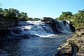
Salto Piraretá
-
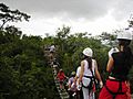
Eco reserve Mbatovi


See also
 In Spanish: Departamento de Paraguarí para niños
