
Pelton Peak facts for kids
Quick facts for kids Pelton Peak |
|
|---|---|

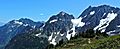
Pelton Peak, northwest aspect
|
|
| Highest point | |
| Elevation | 7,132 ft (2,174 m) |
| Prominence | 600 ft (180 m) |
| Geography | |

Pelton Peak
Location in Washington (state)

Pelton Peak
Location in the United States
|
|
| Parent range | North Cascades Cascade Range |
| Topo map | USGS Cascade Pass |
| Type of rock | OrthoGneiss, Schist |
| Climbing | |
| First ascent | August 3, 1948 by Lawrence E. Nielsen and Walt Price |
| Easiest route | Scrambling via Magic-Pelton col |
Pelton Peak is a mountain in Washington state, standing at 7,132-foot (2,174-metre) tall. It is located in Chelan County. This peak is part of the North Cascades, which is a larger part of the Cascade Range. Pelton Peak is about 1.8 miles (2.9 km) southeast of Cascade Pass inside North Cascades National Park. It is also near the northern end of a popular hiking route called the Ptarmigan Traverse.
The closest taller peak is Magic Mountain, just 0.4 miles (0.64 km) away to the southwest. A glacier called the Yawning Glacier sits on the western side of Pelton Peak, between it and Magic Mountain. Water from the mountain flows into streams that lead to the Stehekin River. The mountain got its name from the Pelton wheel. This was a type of water wheel used in old mining operations. Many mines used to be in the areas around Pelton Basin, Horseshoe Basin, and Boston Basin.
Understanding Pelton Peak's Climate
Pelton Peak is in a marine west coast climate zone. This means it gets a lot of moisture from the Pacific Ocean. Most weather fronts, which are like big weather systems, come from the Pacific Ocean. They then travel northeast towards the Cascade Mountains.

When these weather fronts reach the North Cascades, the tall mountains force the air upwards. As the air rises, it cools down and drops its moisture. This causes a lot of rain or snow to fall on the Cascades. This process is called Orographic lift. Because of this, the western side of the North Cascades gets a lot of precipitation, especially snow in winter.
During winter, the weather is often cloudy. But in summer, high-pressure systems over the Pacific Ocean usually bring clear skies. Since the climate is influenced by the ocean, the snow tends to be wet and heavy. This can create a high risk of avalanches.

How Pelton Peak's Geology Formed
The North Cascades area has very rugged land. You can see sharp peaks, rocky ridges, deep glacial valleys, and tall granite spires. The amazing shapes of the land and the big changes in elevation were created by geological events that happened millions of years ago. These changes also led to different climates and types of plants in the area.
The Cascade Range began forming millions of years ago, during the late Eocene Epoch. At that time, the North American Plate was moving over the Pacific Plate. This movement caused many periods of volcanic activity. Also, small pieces of the Earth's crust, called terranes, came together to form the North Cascades about 50 million years ago.
Over two million years ago, during the Pleistocene period, glaciers repeatedly moved across the land. As they moved, they carved out the landscape and left behind rock debris. The river valleys in this area have a "U"-shape. This shape was created by these recent glaciers. The rising of the land (uplift) and cracks in the Earth's crust (faulting), combined with the action of glaciers, have shaped the tall peaks and deep valleys of the North Cascades.
Images for kids
-
View from Sahale Arm with Pelton Peak centered, Glory Mountain (left), and Magic Mountain to right
