South India facts for kids
Quick facts for kids
South India
|
|
|---|---|
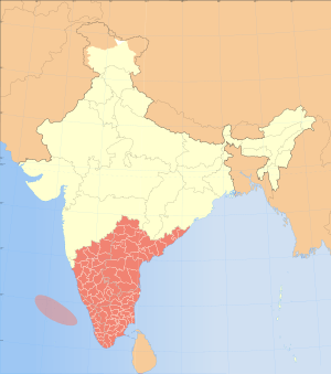
Map of states and Union Territories in South India
|
|
| Country | |
| States and Union territories | |
| Most populous cities (2011) | |
| Area | |
| • Total | 635,780 km2 (245,480 sq mi) |
| Population | |
| • Total | 253,051,953 |
| • Density | 398.0181/km2 (1,030.862/sq mi) |
| Time zone | IST (UTC+5:30) |
| Official languages | |
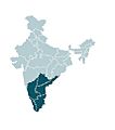
South India is a big region in the southern part of the country India. It's a land of diverse cultures, beautiful landscapes, and unique traditions. This area includes several states and union territories. It is home to over 250 million people.
The main states in South India are:
It also includes the union territories of:
- Andaman and Nicobar (a group of islands)
- Lakshadweep (another group of islands)
- Puducherry (a collection of small areas)
Contents
Exploring South India
South India is a vibrant place with a rich history. It is known for its ancient temples, beautiful beaches, and green hills. The region has a unique culture that is different from other parts of India.
Geography and Climate
South India is mostly a peninsula. This means it is surrounded by water on three sides. The Arabian Sea is to the west, the Bay of Bengal is to the east, and the Indian Ocean is to the south. The Western Ghats and Eastern Ghats are two mountain ranges that run along the coasts. The highest point in South India is Anamudi peak in Kerala. It stands at 2,695 meters (8,842 feet) tall.
The climate in South India is mostly tropical. This means it is warm all year round. The region gets a lot of rain, especially during the monsoon season. This helps the land stay green and fertile.
People and Languages
The people of South India are diverse. They speak several different languages. The main languages are Tamil, Telugu, Kannada, and Malayalam. These languages belong to the Dravidian language family. English and Urdu are also spoken in some areas.
The culture in South India is very rich. It has ancient traditions in music, dance, and art. Many people wear traditional clothes like saris and dhotis. Festivals are a big part of life here.
Major Cities
South India has many large and busy cities. These cities are centers for business, education, and culture. Some of the biggest cities include:
- Chennai: The capital of Tamil Nadu, known for its beaches and temples.
- Bengaluru: The capital of Karnataka, often called the "Silicon Valley of India" because of its technology industry.
- Hyderabad: The capital of Telangana, famous for its historical sites and delicious food.
- Kochi: A major port city in Kerala, known for its backwaters and spice trade history.
- Visakhapatnam: A port city in Andhra Pradesh, with beautiful beaches and a busy harbor.
Economy and Industries
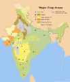
The economy of South India is strong and growing. Agriculture is very important. Farmers grow crops like rice, sugarcane, cotton, and spices. The region is also a major hub for information technology (IT) and software development. Many global tech companies have offices here.
Other important industries include:
- Manufacturing: Making cars, electronics, and other goods.
- Tourism: People visit for the beautiful scenery, historical sites, and cultural experiences.
- Textiles: Producing fabrics like Calico.
- Fisheries: Fishing is important along the long coastline.
Large dams like the Idukki Dam in Kerala help provide water and electricity. The region also has several busy airports and ports. These help with trade and travel.
Wildlife and Nature
South India is home to a wide variety of animals and plants. It has many national parks and wildlife sanctuaries. These places protect animals like:
- Elephants: South India has the largest population of elephants in India.
- Tigers: These majestic big cats can be found in some protected areas.
- Leopards: Another type of big cat that lives in the forests.
- Various bird species: Many colorful birds live in the region's diverse habitats.
The Western Ghats are a UNESCO World Heritage Site. They are known for their amazing biodiversity. This means they have many different kinds of plants and animals, some of which are found nowhere else in the world.
Food and Cuisine
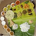
South Indian food is famous around the world. It is known for its use of rice, lentils, and spices. Many dishes are vegetarian. Some popular foods include:
- Dosa and Idli: These are savory pancakes and steamed rice cakes, often eaten for breakfast.
- Sambhar and Rasam: These are flavorful lentil and tamarind-based soups.
- Biryani: A delicious rice dish cooked with meat or vegetables and spices.
- Curries: Many different types of curries are made with vegetables, fish, or meat.
Food is often served on a banana leaf, especially during festivals or special occasions.
Art and Architecture
South India has a rich artistic heritage. This includes classical dance forms like Bharatanatyam and Kathakali. Music, especially Carnatic music, is also very popular.
The region is famous for its stunning temple architecture. Many temples have tall, decorated towers called gopurams. These temples are not just places of worship. They are also amazing examples of ancient engineering and art. The Meenakshi Temple in Madurai is a famous example.
Images for kids
-
Ancient Silk Road map. The Spice trade was mainly along the water routes (blue).
-
Technopark, Trivandrum
-
The growth of information technology hubs in the region have spurred economic growth. Pictured is Tidel Park in Chennai
-
The weave of Calico sample from a shopping bag shown against a centimetre scale.
-
A Thalassery cuisine which makes use of Malabar spices
-
The large gopuram is a hallmark of Dravidian architecture.
 In Spanish: India meridional para niños
 | Selma Burke |
 | Pauline Powell Burns |
 | Frederick J. Brown |
 | Robert Blackburn |


