
Percé Rock facts for kids
Quick facts for kids Percé RockRocher percé |
|
|---|---|
.jpg) |
|
| Highest point | |
| Elevation | 88 m (289 ft) |
| Geography | |

Percé Rock
Rocher percé Location in Quebec
|
|
| Location | Percé, Quebec, Canada |
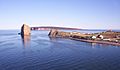
Percé Rock (which means "pierced rock" in French) is a giant rock formation in the Gulf of Saint Lawrence. You can find it at the very tip of the Gaspé Peninsula in Québec, Canada. This amazing rock stands tall off Percé Bay.
From far away, Percé Rock looks a lot like a ship sailing on the water. It is one of the biggest natural arches in the world that stands in the sea. This rock is a very important natural symbol of Quebec, known for its interesting geology and long history. It is a main attraction in the Gaspésie region.
Contents
What Does Percé Rock Mean?
This huge rock cliff has many names. People call it le Rocher Percé, Pierced Rock, Pierced Island, Split Rock, or simply Percé Rock. The name comes from the hole in the rock, which forms an arch about 15 meters (49 feet) high on its ocean side. It looks as if a needle has cut right through the rock!
Samuel de Champlain gave it the name Percé ("pierced rock") in 1607. He saw the holes in the massive limestone rock. Over many years, this rock has become a major tourist spot in Quebec.
Legends of Percé Rock
Percé Rock is sometimes called "the monstrous giant." People say its immense eye changes color, from green to gray, blue, or violet, depending on the sea's mood. There is a legend that links the rock to a young man from a noble French family.
Another story told by local people in Percé town says they see the rock as a "phantom" during storms. They call it "Le Génie de l'Isle Percée," which means "The Spirit of the Pierced Island." This might be because misty clouds often surround the rock. These clouds can make it look like a ghostly figure from a distance.
Where is Percé Rock Located?

Percé Rock is part of a group of cliffs, bays, and hills on the southwest side of the Gulf of Saint Lawrence. These formations are made of reddish-gold limestone and shale. At low tide, a sandbar connects Percé Rock to the mainland. You can even walk to it from Rue du Mont Joli.
Percé Bay sits between this rock and High Head. There is also a reef southwest of Percé Rock, about 0.5 miles (0.8 km) from the shore. The town of Percé is right on the bay. Fishing is the main industry there.
Fossils and Geology
The rock formation itself holds about 150 different kinds of fossils. Nearby, on Bonaventure Island, you can find conglomerate rocks. These rocks are from the Carboniferous period, which was more than 310 million years ago.
National Park and Wildlife
Right next to Percé Rock is Bonaventure Island. Together, they form the Parc national de l'Île-Bonaventure-et-du-Rocher-Percé. This park was created in 1985 and covers about 5.8 square kilometers (2.2 square miles). Percé Rock is the only one of the Gaspé Peninsula's five geological formations located inside the park.
The park's coastline stretches for 2 kilometers (1.2 miles). It is home to many different plants and animals. It is a special place for migratory birds, especially the northern gannet. The park has over 110,000 nesting northern gannets. This is the second-largest colony of these birds in the world! Other birds you might see include puffins, razorbills, black guillemots, and kittiwakes. There are also more than 200 other bird species.
From May to December, you might even spot some large sea animals. Blue whales, humpback whales, minke whales, or fin whales can be seen along the coast near Percé, Bonaventure Island, and Forillon National Park.
Visiting the Rock
You can walk to Percé Rock at low tide. Boat trips from Percé to the rock and the bird colony on Bonaventure Island take about 75 minutes. You can visit the rock between May 28 and October 12. Park guides share information about the creatures on the beach and the geology of Percé Rock. They also talk about the fossils found there.
The rock is a single huge piece of stone, weighing an estimated 5 million tonnes. Scientists believe that at its current rate of erosion (about 300 tonnes lost each year from water and wind), it will disappear in about 16,000 years. Because parts of it can collapse, it is not safe to go too close to the rock on foot during low tide. The very top of the rock is too high to reach. Many birds, like snowy gannets, silvery gulls, and black cormorants, perch there.
There is an interpretation center in Percé, located in a beautiful restored building called Le Chafaud. It has an exhibit called "Un rocher, une île, un parc national" (meaning "one rock, one island, one national park"). This exhibit tells the story of the park's birds, marine life, geology, history, and ecosystem.
What Does Percé Rock Look Like?

.jpg)
Percé Rock is a massive limestone stack formation. It has veins of sandstone and siltstone, and its sides are very steep. The rock is 433 meters (1,421 feet) long, 90 meters (295 feet) wide, and 88 meters (289 feet) high at its tallest point. Some people say it looks like a giant "beached supertanker" from certain angles.
For about four hours during low tide, the water pulls back from a wide spit. This allows people to walk out and visit the rock itself.
History of Percé Rock

The huge limestone of Percé Rock is very old. Geologists say it formed during the Devonian period, more than 400 million years ago. Sir William Edmond Logan, often called the father of Canadian geology, first mapped these rocks in 1844. Fossils found in these rocks show many different kinds of ancient animals and plants. These include brachiopods, trilobites, dalmanites, corals, and marine worms from the Devonian period.
It is believed that Percé Rock was once connected to the mainland. When Jacques Cartier, one of the first European explorers, arrived in 1534, he reported seeing three arches in the rock. Over time, two of these arches disappeared. The last one collapsed on June 17, 1845, leaving behind a separate pillar.
When Samuel de Champlain, the French geographer and founder of Quebec City, saw the rock in 1603, it only had one arch. However, a picture drawn in 1760 by an English officer, Captain Hervey Smyth, showed two arches. One of these collapsed in June 1845. The sea waves cut the two large holes in Percé Rock. The arch you can see today is described as a "gothic arch of rock," about 15 meters (49 feet) high. A small boat can even pass through this arch during high tide. The outer arch that collapsed in 1845 now looks like a tall stone pillar.
In the early 1900s, people started visiting the Gaspé, Percé, and Bonaventure Island areas. They were enchanted by the beauty of Percé Rock.
Images for kids
-
Percé village, Percé Rock and the Parc national de l'île-Bonaventure-et-du-Rocher-Percé (Bonaventure Island and Percé Rock National Park)
.JPG)
See also
 In Spanish: Rocher Percé para niños
