Polk County, Georgia facts for kids
Quick facts for kids
Polk County
|
|
|---|---|

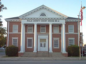
Polk County Courthouse in Cedartown
|
|

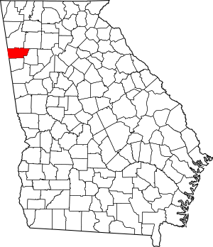
Location within the U.S. state of Georgia
|
|
 Georgia's location within the U.S. |
|
| Country | |
| State | |
| Founded | December 20, 1851 |
| Named for | James K. Polk |
| Seat | Cedartown |
| Largest city | Cedartown |
| Area | |
| • Total | 312 sq mi (810 km2) |
| • Land | 310 sq mi (800 km2) |
| • Water | 1.8 sq mi (5 km2) 0.6%% |
| Population
(2020)
|
|
| • Total | 42,853 |
| • Estimate
(2023)
|
44,223 |
| • Density | 137.35/sq mi (53.03/km2) |
| Time zone | UTC−5 (Eastern) |
| • Summer (DST) | UTC−4 (EDT) |
| Congressional district | 14th |
Polk County is a place in the northwest part of Georgia. In 2020, about 42,853 people lived there. Its main town, or county seat, is Cedartown.
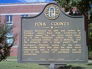
Polk County was started on December 20, 1851. It was named after James K. Polk, who was the eleventh President of the United States.
Contents
Geography of Polk County
Polk County covers about 312 square miles. Most of this area, around 310 square miles, is land. Only a small part, about 1.8 square miles, is water.
The county has many rolling hills and small mountains. These are part of the Piedmont Plateau and the Ridge-and-Valley Appalachians. Both of these are smaller parts of the larger Appalachian Mountains.
The tallest of these small mountains is Shorty Mountain. It is near the community of Etna and is about 1,610 feet (491 meters) high. Signal Mountain in Rockmart is also important. It is about 1,290 feet (393 meters) high.
Most of eastern Polk County, around Rockmart, is in the Etowah River area. Most of western Polk County, around Cedartown, is in the Upper Coosa River area. Both of these rivers are part of the larger ACT River Basin.
Major Roads in Polk County
 U.S. Route 27
 U.S. Route 27 Business
 U.S. Route 278
 U.S. Route 278 Business
 State Route 1
 State Route 1 Business
 State Route 6
 State Route 6 Business
 State Route 100
 State Route 101
 State Route 113
Neighboring Counties
Polk County shares borders with these other counties:
- Floyd County – to the north
- Bartow County – to the northeast
- Paulding County – to the east
- Haralson County – to the south
- Cleburne County, Alabama – to the southwest
- Cherokee County, Alabama – to the west
People of Polk County
| Historical population | |||
|---|---|---|---|
| Census | Pop. | %± | |
| 1860 | 6,295 | — | |
| 1870 | 7,822 | 24.3% | |
| 1880 | 11,952 | 52.8% | |
| 1890 | 14,945 | 25.0% | |
| 1900 | 17,856 | 19.5% | |
| 1910 | 20,203 | 13.1% | |
| 1920 | 20,357 | 0.8% | |
| 1930 | 25,141 | 23.5% | |
| 1940 | 28,467 | 13.2% | |
| 1950 | 30,976 | 8.8% | |
| 1960 | 28,015 | −9.6% | |
| 1970 | 29,656 | 5.9% | |
| 1980 | 32,386 | 9.2% | |
| 1990 | 33,815 | 4.4% | |
| 2000 | 38,127 | 12.8% | |
| 2010 | 41,475 | 8.8% | |
| 2020 | 42,853 | 3.3% | |
| 2023 (est.) | 44,223 | 6.6% | |
| U.S. Decennial Census 1790-1880 1890-1910 1920-1930 1930-1940 1940-1950 1960-1980 1980-2000 2010 |
|||
2020 Census Information
In 2020, there were 42,853 people living in Polk County. There were 15,038 households and 10,151 families.
The people living in Polk County included:
- About 70.4% White (non-Hispanic)
- About 11.9% Black or African American (non-Hispanic)
- About 13.0% Hispanic or Latino
- Other groups made up smaller percentages.
2010 Census Information
In 2010, there were 41,475 people living in the county. The population density was about 133.6 people per square mile.
About 77.1% of the people were white. About 12.5% were black or African American. About 11.8% of the population was of Hispanic or Latino origin.
The average household had 2.72 people. The average family had 3.20 people. The median age of people in the county was 36.2 years old.
Fun Things to Do
- Silver Comet Trail
Local News
- Polk County Standard Journal
Towns and Communities
Cities
- Aragon
- Braswell
- Cedartown (This is the county seat, or main town)
- Rockmart
- Taylorsville (Part of this city is also in Bartow County)
See also
 In Spanish: Condado de Polk (Georgia) para niños
 | DeHart Hubbard |
 | Wilma Rudolph |
 | Jesse Owens |
 | Jackie Joyner-Kersee |
 | Major Taylor |


