Poquessing Creek facts for kids
Poquessing Creek is a stream about 10.3 miles (16.6 km) long. It flows into the Delaware River and helps form the border between Bucks County and the northeast part of Philadelphia, Pennsylvania. This creek has been a boundary between these two counties since 1682.
The creek starts in Trevose and winds its way southeast. It eventually empties into the Delaware River. The name "Poquessing" comes from the Lenape language. It means "place of the mice." Long ago, the spot where Poquessing Creek meets the Delaware River was thought to be a good place for William Penn to build Philadelphia. For many years, the area around the creek was even called "Old Philadelphia."
Poquessing Creek and its smaller streams drain an area of about 21.5 square miles (55.7 km2). This area includes parts of Philadelphia, Montgomery, and Bucks counties. It covers parts of towns like Philadelphia, Upper Southampton, Lower Southampton, Lower Moreland, and Bensalem.
Unlike many other city streams, Poquessing Creek has mostly avoided being turned into storm sewers. This process, called "channelization," changed many waterways in the past. It made land flat for building and helped keep city streets in a neat, rectangular grid. However, by the 1930s, people realized this process caused many problems.
In the late 1950s, new neighborhoods like Morrell Park were built differently. Their streets curved to fit the natural land. This meant less need to flatten or fill the ground. For a long time, areas near Byberry Creek (which flows into Poquessing) were left undeveloped. Even though some building happened later, Poquessing Creek itself was mostly saved. Only a very small, unnamed creek near Fluehr Park was affected by channelization.
Byberry Creek and its two branches, Wilsons Run and Waltons Run, still flow freely. The city owns and manages them as part of its storm sewer system. Even so, they are beautiful streams when the water levels are low.
Contents
What is Poquessing Creek's Geology?
Poquessing Creek begins its journey flowing over a type of rock called felsic gneiss. This rock formed in the Cambrian period. It is made of minerals like quartz, microcline, pyroxene, and biotite. The rock is usually a buff or pink color and has fine to medium grains.
Next, the creek flows into an area with the Wissahickon Formation. This rock formed in the Paleozoic era. It is a schist, which is a metamorphic rock. It contains minerals like garnet, staurolite, kyanite, and sillimanite. Some types of this schist include oligoclase-mica schist.
As Poquessing Creek flows along the border of Philadelphia and Bucks County, it passes over other rock layers. These are the Pennsauken and Bridgeton Formations from the Tertiary period. They are made of quartz sand. These layers sit on top of the Wissahickon Formation. However, the creek has worn away these upper layers. So, it flows directly on the older Wissahickon Formation.
Finally, in its last few hundred yards before reaching the Delaware River, the creek flows through the Trenton Gravel formation. This rock is from the Quaternary period. It is made of reddish-brown gravelly sand and silt.
What are Poquessing Creek's Tributaries?
A tributary is a smaller stream or river that flows into a larger one. Here are some of the streams that flow into Poquessing Creek:
- Black Lake Run
- Bloody Run
- Byberry Creek
- Colberts Run
- Elwoods Run
- Waltons Run
- Wilsons Run
Historic Bridges Over Poquessing Creek
Many old and interesting bridges cross Poquessing Creek.
Quick facts for kids |
|
|
Frankford Avenue Bridge
|
|

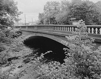
Frankford Avenue bridge over the Poquessing Creek.
|
|
| Location | Philadelphia, Pennsylvania |
|---|---|
| Built | 1904 |
| Architect | John McMenamy |
| MPS | Highway Bridges Owned by the Commonwealth of Pennsylvania, Department of Transportation TR |
| NRHP reference No. | 88000850 |
| Added to NRHP | June 22, 1988 |
- One stone arch bridge, built in 1805, used to carry the King's Highway. It was later improved in 1917 for the Lincoln Highway. However, a new road, the Roosevelt Boulevard, bypassed it in 1921. This bridge is no longer used.
- Another stone arch bridge, built in 1845, carries Red Lion Road. It is near where the old Red Lion Inn used to be. This bridge is still in use today.
- A stone arch bridge at Richlieu Road, built in 1840, is also no longer used.
- A stone arch bridge at Century Lane, built in 1853, connected two villages. It is 42 feet long and is still used.
- The Frankford Avenue bridge was built in 1904. It is a concrete arch bridge where Frankford Avenue meets Bristol Pike (U.S. Route 13). This bridge is special because it was one of the first to use concrete in a modern way. It was added to the National Register of Historic Places in 1988 and is still in use.
- A stone bridge with four arches, built in the 1800s, carries the Northeast Corridor rail line (originally the Pennsylvania Railroad) over the Poquessing Creek and Grant Avenue in Philadelphia.
How Poquessing Creek Got Its Name
The name "Poquessing" has changed over time. Old maps and records show different spellings and names for the creek. For example, on one map, it was called Pouquessinge and La Riviere de Kakimon's. "Kakamon's" was a name for the pike fish, so it might have been called "Pike Creek." Another map called it Drake Kylen or Dragon River. Early documents also used names like Poetquessingh and Potquessin.
 | James Van Der Zee |
 | Alma Thomas |
 | Ellis Wilson |
 | Margaret Taylor-Burroughs |


