Port-au-Prince facts for kids
Quick facts for kids
Port-au-Prince
Pòtoprens
|
||
|---|---|---|
|
Capital city and commune
|
||
Port-au-Prince
|
||
|
||
| Motto(s):
Je luis pour tous
"I shine for all" |
||
| Country | Haiti | |
| Department | Ouest | |
| Région | Gonave-Azuei | |
| Arrondissement | Capitale-National | |
| Founded | 1749 | |
| Colonial seat | 1770 | |
| Area | ||
| • Capital city and commune | 36.04 km2 (13.92 sq mi) | |
| • Metro | 158.50 km2 (61.20 sq mi) | |
| Population
(2022 est.)
|
||
| • Capital city and commune | 1,200,000 | |
| • Density | 27,395/km2 (70,950/sq mi) | |
| • Metro | 2,618,894 | |
| • Metro density | 16,523/km2 (42,790/sq mi) | |
| Demonym(s) | Port-au-Princien(s) (masc.), Port-au-Princienne(s) (fem.) (en) and (fr) | |
| Time zone | UTC-05:00 (Eastern Time Zone) | |
| • Summer (DST) | UTC-04:00 (Eastern Time Zone) | |
Port-au-Prince is the capital and largest city of Haiti. In 2022, about 1,200,000 people lived in the city. The larger metropolitan area had around 2,618,894 people. This area includes nearby towns like Delmas, Cité Soleil, Tabarre, Carrefour, and Pétion-Ville.
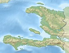
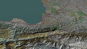
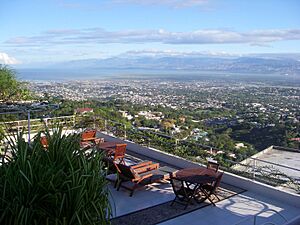
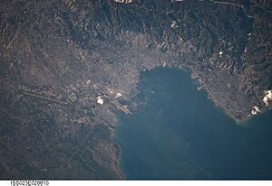
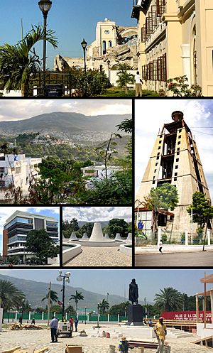
The city is located on the Gulf of Gonâve. This bay has a natural harbor, which has been important for trade for a very long time. It was officially founded by the French in 1749. Port-au-Prince looks like an amphitheater. Business areas are close to the water. Homes are built on the hills above. Many people live in crowded neighborhoods on these hills.
In 2010, a huge earthquake hit the city. It caused a lot of damage and destroyed many buildings. The Haitian government estimated that 230,000 people died.
Contents
- What's in a Name? The Meaning of Port-au-Prince
- A Look Back: The History of Port-au-Prince
- Exploring Port-au-Prince: Geography
- Who Lives Here? Port-au-Prince Demographics
- Making a Living: Port-au-Prince Economy
- Art and Traditions: Port-au-Prince Culture
- Learning in Port-au-Prince: Education
- Getting Around: Transportation
- See also
What's in a Name? The Meaning of Port-au-Prince
The name Port-au-Prince means "Prince's Port" in French. It's not fully clear which prince it refers to. One idea is that it was named after a ship called Le Prince. This ship arrived in the area in 1706. However, some small islands in the bay were already called "Prince's islets" as early as 1680. So, the ship might not be the reason.
The area was also known as Hôpital (Hospital). This was because of a hospital set up by early settlers. In 1793, a French official renamed the city Port-Républicain. This was to remind people of the French Revolution. But later, Jean-Jacques Dessalines, Haiti's first emperor, changed it back to Port-au-Prince.
When Haiti was divided, Port-au-Prince was the capital of the southern part. The northern leader, Henri Christophe, even called it Port-aux-Crimes after an important person was killed nearby.
A Look Back: The History of Port-au-Prince
Early Inhabitants: The Taíno People
Before Christopher Columbus arrived, the Taíno people lived on the island of Hispaniola. They came around 2600 BC in large canoes. The area where Port-au-Prince is now was part of the Xaragua chiefdom. The Taíno people used the flat areas for hunting. They avoided living too close to the coast because of attacks from other groups.
Spanish Arrival and Changes
When the Spanish arrived in 1492, the Taíno population was large. But within 30 years, most of them were gone. This was due to violence, new diseases, and harsh treatment. The Spanish took control of the land. They founded a settlement called Santa Maria del Puerto. This settlement was burned twice by other European explorers. In 1606, the Spanish left the area.
French Settlers and Pirates
For over 50 years, the Port-au-Prince area was mostly empty. Then, French buccaneers and traders started using it as a base. Around 1650, French flibustiers (a type of pirate) moved in. They built a hospital, which led to the area being called Hôpital.
Spain still claimed the land. But the French settlers were too many. In 1697, Spain gave up its claim in the Treaty of Ryswick. The French governor tried to control the flibustiers. They closed their hospital rather than give it up. Many of them then became farmers.
In 1706, a ship named Le Prince sailed into the bay. Some say the area was named Port-au-Prince after this ship. But the small islands nearby were already called "Prince's islets" earlier.
Founding the Capital City
Over time, the French decided they needed a capital city for their colony, Saint-Domingue. After looking at other towns, they chose the Port-au-Prince area. It was in a good central location and easier to defend. So, in 1749, the city of Port-au-Prince was officially founded.
In 1770, Port-au-Prince became the capital of the French colony. In 1791, it was burned during a battle. British troops captured it in 1794.
In 1804, Haiti became independent, and Port-au-Prince became its capital. After Jean-Jacques Dessalines was killed in 1806, Haiti was split. Port-au-Prince was the capital of the southern part. It became the capital of all Haiti again in 1820.
American Presence in Port-au-Prince
During the time the United States occupied Haiti (1915–1934), American Marines were stationed in Port-au-Prince. The city was attacked twice by Haitian rebels. The American and Haitian forces won both battles.
The 2010 Earthquake
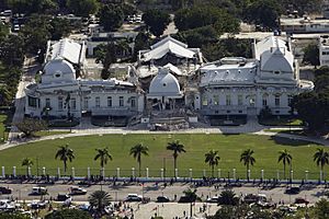
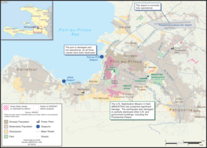
On January 12, 2010, a powerful 7.0 magnitude earthquake hit Port-au-Prince. It caused huge damage to the city. Many important buildings were destroyed. These included the Cathedral, the capital building, and the Presidential Palace. The seaport and airport were also damaged. This made it hard for aid to arrive.
Many countries and groups sent help to Port-au-Prince. A strong aftershock hit on January 20, 2010, causing more damage. The City Hall and other government buildings were also destroyed.
Hurricanes and Storms
Haiti often faces hurricanes. In 2008, four major storms hit the country. Nearly 800 people died, and many homes and crops were destroyed. In 2012, Hurricane Sandy caused 75 deaths and a lot of damage. It also led to a rise in cholera cases. In 2016, Hurricane Matthew caused severe damage and over 500 deaths in Haiti. These storms often lead to humanitarian crises.
Exploring Port-au-Prince: Geography
Port-au-Prince is divided into several districts called communes. Pétion-Ville is a wealthy suburban area southeast of the city. Delmas is north of the city center. Carrefour is southwest.
The city has many low-income areas. One well-known area is Cité Soleil. This area used to be part of Port-au-Prince but is now its own commune. The Champ de Mars area in downtown Port-au-Prince is seeing new building projects.
Weather in Port-au-Prince: Climate
Port-au-Prince has a tropical wet and dry climate. Temperatures stay fairly constant all year. The wet season is from March to November. The most rain falls in April-May and August-October. June and July have a bit less rain. The dry season is from December to February. The city is generally warm and humid in the dry season. It is hot and humid in the wet season.
| Climate data for Port-au-Prince | |||||||||||||
|---|---|---|---|---|---|---|---|---|---|---|---|---|---|
| Month | Jan | Feb | Mar | Apr | May | Jun | Jul | Aug | Sep | Oct | Nov | Dec | Year |
| Mean daily maximum °C (°F) | 31 (88) |
31 (88) |
32 (90) |
32 (90) |
33 (91) |
35 (95) |
35 (95) |
35 (95) |
34 (93) |
33 (91) |
32 (90) |
31 (88) |
33 (91) |
| Daily mean °C (°F) | 27 (81) |
26.5 (79.7) |
27 (81) |
28 (82) |
28 (82) |
30 (86) |
30 (86) |
29.5 (85.1) |
28 (82) |
28 (82) |
27 (81) |
26.5 (79.7) |
28.0 (82.3) |
| Mean daily minimum °C (°F) | 23 (73) |
22 (72) |
22 (72) |
23 (73) |
23 (73) |
24 (75) |
25 (77) |
24 (75) |
24 (75) |
24 (75) |
23 (73) |
22 (72) |
23 (74) |
| Average rainfall mm (inches) | 33 (1.3) |
58 (2.3) |
86 (3.4) |
160 (6.3) |
231 (9.1) |
102 (4.0) |
74 (2.9) |
145 (5.7) |
175 (6.9) |
170 (6.7) |
86 (3.4) |
33 (1.3) |
1,353 (53.3) |
| Average rainy days (≥ 1 mm) | 3 | 5 | 7 | 11 | 13 | 8 | 7 | 11 | 12 | 12 | 7 | 3 | 99 |
| Mean monthly sunshine hours | 279.0 | 254.2 | 279.0 | 273.0 | 251.1 | 237.0 | 279.0 | 282.1 | 246.0 | 251.1 | 240.0 | 244.9 | 3,116.4 |
| Source: Climate & Temperature | |||||||||||||
Who Lives Here? Port-au-Prince Demographics
Most people in Port-au-Prince are of African descent. There is also a notable biracial minority. This group often controls many businesses in the city. There are also people of Asian and European backgrounds.
Many residents have Arab roots, especially from Syria, Lebanon, and Palestine. They often run businesses in the city's financial areas. Most biracial residents live in the wealthier parts of the city.
Making a Living: Port-au-Prince Economy
Port-au-Prince is a major economic and financial center in Haiti. The city exports important goods like coffee and sugar. In the past, it also exported shoes and baseballs. Port-au-Prince has factories that process food, make soap, textiles, and cement.
Even with political challenges, the city's economy relies on tourism and construction. Port-au-Prince used to be a popular stop for cruise ships. However, it has lost most of its tourism and no longer has cruise ships visiting.
Unemployment is high in Port-au-Prince. Many people work in informal jobs, selling goods and services on the streets. This is especially true in the city's poorer areas, where people need to find ways to survive. Some upscale areas of Port-au-Prince have lower crime rates than the city center.
The Toussaint Louverture International Airport is Haiti's main airport for tourists. Visitors often go to the Pétion-Ville area. They also enjoy seeing the unique gingerbread houses.
Art and Traditions: Port-au-Prince Culture
The city's culture is centered around the National Palace and its surroundings. The National Museum is located near the palace. It was founded in 1938. The original National Palace was destroyed and rebuilt in 1918. It was then destroyed again in the 2010 earthquake.
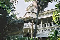
Another famous place is the Hotel Oloffson. It's a 19th-century gingerbread mansion. It used to be the home of two former Haitian presidents. Now, it's a popular spot for tourists. The Cathédrale de Port-au-Prince is also a famous cultural site. It attracts visitors with its beautiful Neo-Romantic style.
The Musée d'Art Haïtien du Collège Saint-Pierre displays art from talented Haitian artists. The Musée National has historical items, like an old anchor. Some believe it came from Christopher Columbus's ship, the Santa María. Other cultural places include the Archives Nationales and the Bibliothèque Nationale (National Library). The city is also the birthplace of famous artist Gesner Abelard. The Musée du Panthéon National Haïtien (MUPANAH) tells the story of Haiti's independence heroes, history, and culture.
In 2015, a new LDS Temple was announced for Port-au-Prince.
Port-au-Prince has streets named after American abolitionist heroes. One is named for John Brown. Another is named for Senator Charles Sumner.
Special Celebrations
A celebration called Fet Gede takes place from November 1st (Day of the Dead) to November 3rd. It honors Bawon Samdi and Gran Brigi. People gather at the national cemetery. They wear white cotton clothes and purple headscarves. During the celebration, people offer food to spirits and pour liquor on gravestones.
Learning in Port-au-Prince: Education
Port-au-Prince has many schools and universities. There are small vocational schools and larger universities. Important international schools include Union School, founded in 1919, and Quisqueya Christian School, founded in 1974. Both offer an American-style education before college. French-speaking students can attend the Lycée Français.
The Anís Zunúzí Bahá'í School is northwest of Port-au-Prince. It opened in 1980 and survived the 2010 earthquake. Its staff helped with relief efforts. The school teaches in Haitian Creole and French, and also offers English.
The State University of Haiti (Université d'État d'Haïti) is in the capital. Other universities include Quisqueya University and the Université des Caraïbes. Many religious schools are run by missionaries from France or Canada. These include Institution Saint-Louis de Gonzague and École Sainte-Rose-de-Lima.
The Ministry of Education is also in downtown Port-au-Prince. It is next to the National Palace. Groups like the Haitian Group of Research and Pedagogical Activities (GHRAP) have set up community education centers. UNESCO is also working to improve schools in Port-au-Prince.
Getting Around: Transportation
Roads for Travel
All major roads in Haiti either start or pass through Port-au-Prince. Route Nationale #1 (National Highway One) goes north from the city. Route Nationale #2 goes south. These roads needed repairs after 1991. A third highway, Route Nationale #3, connects Port-au-Prince to the central plateau. However, it is not used much because it is in poor condition.
Public Transport Options
The most common way to get around in Haiti is by "tap-taps." These are brightly painted pickup trucks that work like taxis.
The City's Seaport
The seaport, Port international de Port-au-Prince, handles more shipping than any other port in Haiti. It has cranes, large docks, and warehouses. However, these facilities are in poor condition. The port is not used as much as it could be. This might be because its fees are higher than ports in the Dominican Republic.
Air Travel: Airports
Toussaint Louverture International Airport is north of the city. It opened in 1965. This is Haiti's main airport for international flights. Smaller planes can take travelers from this airport to other cities. Companies like Caribintair and Sunrise Airways offer these flights.
See also
 In Spanish: Puerto Príncipe para niños


