Potlatch, Idaho facts for kids
Quick facts for kids
Potlatch, Idaho
|
|
|---|---|

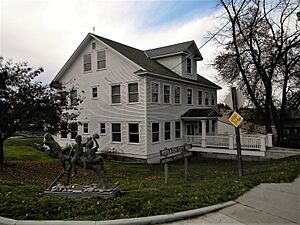
Potlatch City Hall
|
|

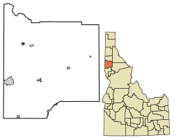
Location of Potlatch in Latah County, Idaho.
|
|
| Country | United States |
| State | Idaho |
| County | Latah |
| Area | |
| • Total | 0.42 sq mi (1.10 km2) |
| • Land | 0.42 sq mi (1.10 km2) |
| • Water | 0.00 sq mi (0.00 km2) |
| Elevation | 2,572 ft (784 m) |
| Population | |
| • Total | 804 |
| • Density | 1,924.35/sq mi (742.40/km2) |
| Time zone | UTC-8 (Pacific (PST)) |
| • Summer (DST) | UTC-7 (PDT) |
| ZIP code |
83855
|
| Area code(s) | 208 |
| FIPS code | 16-64900 |
| GNIS feature ID | 2411478 |
Potlatch is a city in the northwest United States. It is located in north central Idaho in Latah County. The city is about 6 miles (10 km) east of the Washington border. It is part of the Palouse region, north of Moscow. Potlatch is served by State Highway 6. The small community of Onaway borders it to the northeast. In 2010, the population of Potlatch was 804 people.
Contents
History of Potlatch
A Town Built by a Company
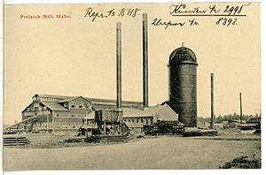
Potlatch was started in 1905 as a company town. This means a company built and owned most of the town. The Potlatch Corporation created it. They chose this spot because it was close to their large forests of Western White Pine trees. The company built a huge sawmill here. When it was finished, it was one of the biggest sawmills in the United States. It was also the largest sawmill in the world for white pine trees.
Most of Potlatch was built quickly in 1906 and 1907. In 1906, 143 houses were built. Another 58 houses were added the next year. Other buildings included places for workers to stay, an ice house, a Catholic church, a hotel, a school, and a general store.
The Potlatch Corporation managed the town. They followed a model similar to the Pullman Company's town in Illinois. The company provided police and fire protection. They also offered a school, churches, a hospital, and a low-cost company store. There were also fun activities for people to do. The company did not allow alcohol in the town. They also encouraged workers to marry. Only married couples could rent the houses they owned.
The company's way of looking after everything was profitable. Even with low rents, the company made money from its "townsite" services. For example, in 1943, they made $59,000. Later, it became less profitable to run the town. So, the mill sold most of the homes and buildings it owned. Potlatch then became an official city.
After the Mill Closed
The large mill closed down in 1981. This happened shortly after the town was sold to its residents. Five years later, a part of the city's business area was added to the National Register of Historic Places. This means it is an important historical site.
After the mill closed, many people in Potlatch started working in other towns. Potlatch became a "bedroom community." This means people live there but travel to nearby university towns like Moscow and Pullman, Washington for work.
Today, leaders in Potlatch are trying to attract new businesses. They are especially interested in companies that make firearms. They have set aside 26 acres (10.5 hectares) for these businesses. This land is where the old mill used to be.
Geography of Potlatch
Potlatch covers a total area of about 0.43 square miles (1.1 square kilometers). All of this area is land. The city is located north of where Rock Creek meets the Palouse River. It sits on the edge of the Palouse region.
Climate in Potlatch
Potlatch has a warm-summer Mediterranean climate. This means it has warm, dry summers and mild, wet winters. Sometimes, its winters are cold enough to be considered a dry-summer humid continental climate.
| Climate data for Potlatch (1915-2012) | |||||||||||||
|---|---|---|---|---|---|---|---|---|---|---|---|---|---|
| Month | Jan | Feb | Mar | Apr | May | Jun | Jul | Aug | Sep | Oct | Nov | Dec | Year |
| Record high °F (°C) | 59 (15) |
65 (18) |
75 (24) |
90 (32) |
95 (35) |
101 (38) |
104 (40) |
110 (43) |
101 (38) |
90 (32) |
71 (22) |
65 (18) |
110 (43) |
| Mean daily maximum °F (°C) | 35.9 (2.2) |
41.6 (5.3) |
48.1 (8.9) |
57.1 (13.9) |
66.0 (18.9) |
72.7 (22.6) |
82.8 (28.2) |
83.0 (28.3) |
73.4 (23.0) |
60.4 (15.8) |
45.2 (7.3) |
37.2 (2.9) |
58.6 (14.8) |
| Mean daily minimum °F (°C) | 21.1 (−6.1) |
24.8 (−4.0) |
28.3 (−2.1) |
32.8 (0.4) |
37.9 (3.3) |
43.1 (6.2) |
45.8 (7.7) |
44.3 (6.8) |
38.9 (3.8) |
33.1 (0.6) |
28.6 (−1.9) |
23.1 (−4.9) |
33.5 (0.8) |
| Record low °F (°C) | −36 (−38) |
−32 (−36) |
−13 (−25) |
15 (−9) |
18 (−8) |
25 (−4) |
27 (−3) |
25 (−4) |
14 (−10) |
9 (−13) |
−20 (−29) |
−48 (−44) |
−48 (−44) |
| Average precipitation inches (mm) | 2.84 (72) |
2.39 (61) |
2.38 (60) |
2.02 (51) |
2.12 (54) |
1.88 (48) |
0.8 (20) |
0.79 (20) |
1.3 (33) |
1.9 (48) |
2.94 (75) |
3.11 (79) |
24.48 (622) |
| Average snowfall inches (cm) | 15.1 (38) |
7.8 (20) |
4.5 (11) |
1.2 (3.0) |
0.1 (0.25) |
0 (0) |
0 (0) |
0 (0) |
0 (0) |
0.3 (0.76) |
4.9 (12) |
11.4 (29) |
45.3 (115) |
| Average precipitation days | 13 | 11 | 11 | 10 | 9 | 7 | 4 | 4 | 5 | 8 | 12 | 12 | 106 |
| Source: WRCC | |||||||||||||
People of Potlatch
How Many People Live Here?
In August 1906, about 1,000 people lived in Potlatch. A year later, the population grew to around 1,500.
| Historical population | |||
|---|---|---|---|
| Census | Pop. | %± | |
| 1910 | 750 | — | |
| 1920 | 1,505 | 100.7% | |
| 1930 | 1,500 | −0.3% | |
| 1940 | 1,409 | −6.1% | |
| 1950 | 1,105 | −21.6% | |
| 1960 | 880 | −20.4% | |
| 1970 | 871 | −1.0% | |
| 1980 | 819 | −6.0% | |
| 1990 | 790 | −3.5% | |
| 2000 | 791 | 0.1% | |
| 2010 | 804 | 1.6% | |
| 2019 (est.) | 814 | 1.2% | |
| U.S. Decennial Census | |||
According to the 2010 census, 804 people lived in the city. There were 339 households and 218 families. The city had about 1,870 people per square mile (722 people per square kilometer). Most residents (97.1%) were White. A small number were African American, Native American, or from other backgrounds. About 2.1% of the population was Hispanic or Latino.
In 2010, about 35.7% of households had children under 18. Nearly half (49.3%) were married couples living together. The average household had 2.37 people. The average family had 2.92 people.
The average age in Potlatch was 32.9 years. About 28.4% of residents were under 18. About 14.8% were 65 years or older. The population was almost evenly split between males (49.6%) and females (50.4%).
Famous Faces from Potlatch
Some notable people have connections to Potlatch:
- Roderick Asher - a geologist who studies the Earth's rocks and history.
- Guyle Fielder - a former NHL (National Hockey League) player.
- Jane Goude - an actress who was born in Potlatch.
- Malcolm Renfrew - a chemist, a scientist who studies chemicals.
- Pat Shea - another former NHL player.
See also
 In Spanish: Potlatch (Idaho) para niños
 | Delilah Pierce |
 | Gordon Parks |
 | Augusta Savage |
 | Charles Ethan Porter |


