
Potomac Water Gap facts for kids
Quick facts for kids Potomac Water Gap |
|
|---|---|
_between_Washington_County,_Maryland_and_Loudoun_County,_Virginia.jpg)
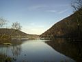
View of the gap from the Sandy Hook Bridge (U.S. Route 340)
|
|
| Elevation | 256 feet (78 m) |
| Traversed by | |
| Location | Loudoun County, Virginia, Jefferson County, West Virginia, Frederick County and Washington County, Maryland, United States |
| Range | Blue Ridge Mountains Appalachian Mountains |
| Coordinates | 39°19′N 77°43′W / 39.32°N 77.72°W |

Location in Maryland
|
|
The Potomac Water Gap is a special place where the Potomac River cuts through the Blue Ridge Mountains. It's located where the states of Virginia, West Virginia, and Maryland meet, close to Harpers Ferry. This gap is the lowest point to cross the Blue Ridge Mountains, sitting at about 256 feet (78 meters) above sea level. It's actually a "double" water gap, meaning the river cuts through two different mountain ridges.
Contents
Where the Mountains Meet the River
The Potomac River flows towards the Blue Ridge Mountains. It then turns south, running alongside the mountains near Bolivar, West Virginia. After that, the river cuts east, flowing past Harpers Ferry.
How the Double Gap Forms
The river first cuts through the mountains at the western edge of the first gap. This gap is between Blue Ridge Mountain to the south (in Virginia and West Virginia) and Elk Ridge Mountain to the north (in Maryland).
The river continues east for about 4 miles (6.4 km). It passes through some fast-moving water called White Horse Rapids. Then, it reaches the second gap. This second gap is between Short Hill Mountain to the south (in Virginia) and South Mountain to the north (in Maryland).
Roads and Railways Through the Gap
Many important routes pass through the Potomac Water Gap. U.S. Route 340 is a major road that goes through it. The Baltimore and Ohio Railroad also uses this gap. A long time ago, the Chesapeake and Ohio Canal also passed through this same area.
History of the Potomac Water Gap
The history of the Potomac Water Gap is closely connected to the nearby town of Harpers Ferry. Many important events happened here.
Famous Visitors and Events
In the past, Thomas Jefferson visited this area. He looked at the gap from a spot called Jefferson Rock and said the view was "worth a trip across the Atlantic." This shows how beautiful and impressive the gap is.
In 1859, a famous event called John Brown's raid happened in Harpers Ferry. Robert E. Lee, who would later become a famous general, quickly came through the gap with a group of Marines. They helped to stop the raid.
The Gap During the Civil War
During the American Civil War, the Potomac Water Gap was very important. Both the Confederate and Union Armies used it often. It was a key way to move through the mountains. There was even fighting in the gap during the Battle of Harpers Ferry.
The Gap Today
Today, the Potomac Water Gap is not just a route for travel. It's also a popular place for tourists to visit. It is part of two national parks:
The famous Appalachian Trail, a long hiking path, also goes through the Potomac Water Gap.
Gallery
-
The eastern gap between South Mountain (left) and Short Hill Mountain (right)
-
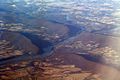
An air photo of the water gaps, looking southwest


