
Prairie Mountain facts for kids
Quick facts for kids Prairie Mountain |
|
|---|---|

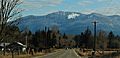
Prairie Mountain seen with Sauk River
|
|
| Highest point | |
| Elevation | 5,678 ft (1,731 m) |
| Prominence | 1,358 ft (414 m) |
| Geography | |

Prairie Mountain
Location in Washington (state)

Prairie Mountain
Location in the United States
|
|
| Location | Snohomish County, Washington, U.S. |
| Parent range | Cascade Range |
| Topo map | USGS Prairie Mountain |
| Climbing | |
| Easiest route | Scrambling class 3 |
Prairie Mountain is a cool mountain peak in Washington state. It stands tall at 5,678 feet (about 1,731 meters) near the edge of the North Cascades mountains. You can find it in Snohomish County, about six miles east of Darrington, Washington.
This mountain is located on land managed by the Mount Baker-Snoqualmie National Forest. It's also northwest of Glacier Peak, which is a type of volcano called a stratovolcano. The closest taller mountain is White Chuck Mountain, which is about 4.7 miles (7.6 km) away to the south-southeast.
Water from Prairie Mountain flows into the Sauk River and Suiattle River. Both of these rivers eventually join the larger Skagit River. The mountain got its name because there's a beautiful open grassy area, like a prairie, at its base.
Understanding Prairie Mountain's Climate
Prairie Mountain is in a special marine west coast climate zone. This means it gets a lot of moisture from the Pacific Ocean. Most weather systems start over the Pacific and move northeast towards the Cascade Range.
When these weather systems hit the tall Cascade Mountains, they are forced to rise. As the air goes higher, it cools down and drops its moisture. This process is called Orographic lift. It causes a lot of rain or snow to fall on the western side of the North Cascades.
Because of this, the west side of the mountains gets a lot of precipitation, especially snow in the winter. Winters are usually cloudy. But in the summer, high-pressure systems over the Pacific Ocean often bring clear skies and sunshine.
Exploring Prairie Mountain's Geology
The North Cascades mountains, where Prairie Mountain is located, have some really rugged and dramatic landscapes. You'll see jagged peaks, long ridges, and deep valleys carved by glaciers. These amazing shapes and big changes in elevation were created by geological events that happened millions of years ago.
These geological events also led to different climates across the Cascade Range. This is why you can find many different types of plants and animals in various ecoregions here.
The Cascade Mountains started forming millions of years ago, during a time called the late Eocene Epoch. This happened because the North American Plate was slowly moving over the Pacific Plate. This movement caused a lot of volcanic activity.
Also, small pieces of the Earth's crust, called terranes, came together to form the North Cascades about 50 million years ago.
During the Pleistocene period, which was over two million years ago, glaciers repeatedly moved across the land. As they moved, they scraped and shaped the landscape. They left behind piles of rock and debris. The "U"-shaped valleys you see today were formed by these glaciers.
The combination of the land being pushed up (called uplift) and cracks in the Earth's crust (called faulting), along with the glaciers, created the tall peaks and deep valleys of the North Cascades area.
- Weather forecast: Prairie Mountain
- Prairie Mountain photo: Flickr
Images for kids
-
Prairie Mountain from Highway 530

