Puebla facts for kids
Quick facts for kids
Puebla
Estado Libre y Soberano
de Puebla |
|||
|---|---|---|---|
|
|||
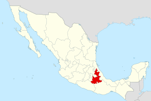
Location within Mexico
|
|||
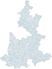
Municipalities of Puebla
|
|||
| Country | |||
| Capital | Puebla | ||
| Municipalities | 217 | ||
| Largest Cities | Puebla Tehuacán |
||
| Admission | December 21, 1823 | ||
| Order | 4th | ||
| Area
Ranked 21st |
|||
| • Total | 33,902 km2 (13,090 sq mi) | ||
| Population
(2005)
|
|||
| • Total | 5,383,133 (Ranked 5th) | ||
| • Demonym | Poblano | ||
| Time zone | UTC-6 (CST) | ||
| • Summer (DST) | UTC-5 (CDT) | ||
| HDI | 0.791 - medium Ranked 28th |
||
| ISO 3166-2 | MX-PUE | ||
| Postal abbr. | Pue. | ||
| Website | www.puebla.gob.mx | ||
Puebla is a Mexican state located in the central part of the country. It is found to the east of Mexico City. Puebla shares its borders with several other states. To the east, it borders Veracruz. To the west, you'll find Hidalgo, Mexico State, Tlaxcala, and Morelos. To the south, it borders Guerrero and Oaxaca.
The state's capital and largest city is Puebla. Another major city is Tehuacan. Puebla is divided into 217 smaller areas called municipalities.
Contents
- What's in a Name? The Story Behind Puebla's Name
- Exploring Puebla's Geography and Landscapes
- Puebla's Economy: How the State Makes Money
- Who Lives in Puebla? Demographics and Culture
- How Puebla is Organized: Municipalities
- Major Cities and Towns in Puebla
- Getting Around: Transportation in Puebla
- Famous People from Puebla
- Images for kids
- See also
What's in a Name? The Story Behind Puebla's Name
The state of Puebla gets its name from its capital city. The city was first called La Puebla de los Angeles, which means "Town of the Angels" in Latin.
Today, the city's full name is Heróica Puebla de Zaragoza. This longer name honors Ignacio Zaragoza. He was a hero who led the Mexican army to victory. They defeated the Imperial French army in the Battle of Puebla on May 5, 1862. This important date is celebrated every year as Cinco de Mayo. Did you know that many Aztec people also lived in the Puebla area long ago?
Exploring Puebla's Geography and Landscapes
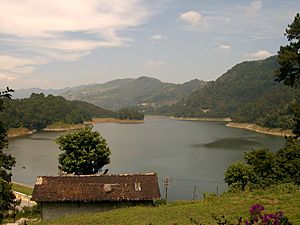
Puebla has a very interesting landscape with many mountains. In the northeast, you'll find part of the Eastern Sierra Madre mountain range. It's known locally as the Northern Sierra of Puebla. The rest of the state is crossed by a chain of volcanoes called the "Transversal Volcanic System."
Towering Peaks and Volcanoes
Some of Mexico's highest mountains are in Puebla. The Pico de Orizaba, also known as Citlaltepetl volcano, is the tallest point in Mexico. It reaches an amazing 5,610 meters (about 18,400 feet) above sea level. Puebla shares this volcano with the state of Veracruz.
Other famous volcanoes in Puebla include Popocatepetl, which is 5,500 meters (about 18,000 feet) high. There's also Iztaccihuatl at 5,230 meters (about 17,160 feet) and the Cerro La Negra.
Rivers and Waterways
Many rivers flow through Puebla, providing water to the state. These include the Atoyac, Tilaza, Mixteco, Nexapa, Pentepec, San Marcos, Salado Cempoala, Zapoteco, Tehuacan, Ajajalpa, and Nexaca rivers. The Nexaca River forms a special water area that is protected as a Natural Reserve.
Plants and Animals of Puebla
The high parts of the Northern Sierra are home to local trees like chanchan, ojoh, and palo de agua. On the volcanic peaks, you'll find forests of pine, oak, and oyamel trees. In the warmer valleys, there are plants that lose their leaves, such as cuajiote, copal, and cuachalalate.
Puebla's wildlife includes animals like leopards, wild boars, wolves, porcupines, badgers, squirrels, and rattlesnakes.
Puebla's Climate Zones
Puebla's climate changes depending on the area. The high volcanic regions and the lowlands often have dry or semi-dry weather. The valleys in the south have a hot and sub-humid climate, meaning they are warm and a bit humid.
Puebla's Economy: How the State Makes Money
Puebla's economy is quite strong. It contributes about 3.7% to Mexico's total economy, making it the seventh largest contributor in the country.
The state's income comes from different areas:
- Services: 22.6% (like healthcare, education, and tourism)
- Manufacturing: 22.5% (making things in factories)
- Commerce, Hotels, and Restaurants: 22% (buying, selling, and places to stay or eat)
- Financial and Real Estate Services: 13.7% (banks, loans, and property)
Puebla is especially known for producing flowers grown outdoors, eggs, coffee, beer, and beans. The state also continues its long tradition of making beautiful items from onyx and marble.
Who Lives in Puebla? Demographics and Culture
In 2003, Puebla had an estimated population of about 5.38 million people. This makes it the 5th most populated state in Mexico.
About 26% of the people live in the capital city, Puebla de Zaragoza. The rest of the population lives in the other 216 municipalities. About 29% of the people live in rural areas, which are smaller towns and countryside.
Languages and Beliefs
Most people in Puebla, about 92%, follow the Catholic faith. About 12% of the population speaks an native language. The most common native language is Nahuatl, followed by Totonac. This means Puebla has the eighth highest percentage of people who speak an indigenous language in Mexico.
How Puebla is Organized: Municipalities
The state of Puebla is divided into seven main regions: Huauchinango, Teziutlán, Ciudad Serdán, San Pedro Cholula, Puebla, Izúcar de Matamoros, and Tehuacán. These regions are then split into 217 smaller areas called municipalities (or municipios in Spanish). Each municipality has its own leader, called a municipal president (like a mayor).
Major Cities and Towns in Puebla
Here are some of the most important communities in Puebla:
- Acatlán de Osorio
- Amozoc de Mota
- Atlixco
- Cholula (Cholula de Rivadabia)
- Cuetzalán
- Huauchinango
- Izúcar de Matamoros
- Puebla, Puebla
- San Martín Texmelucan de Labastida
- Tehuacán
- Teziutlán
- Zacatlan, Puebla
Getting Around: Transportation in Puebla
Puebla has its own airport, the Hermanos Serdan International Airport. This airport helps people travel to and from the state. For getting around within Puebla, cars and buses are the most common ways to travel.
Famous People from Puebla
Many important figures in Mexican history were born or lived in Puebla. Here are a few:
- Ignacio Comonfort - He served as the President of Mexico from 1855 to 1858.
- Juan N. Méndez - Another President of Mexico, serving from 1876 to 1877.
- Manuel Ávila Camacho - He was President of Mexico from 1940 to 1946.
- Gustavo Díaz Ordaz - He served as President of Mexico from 1964 to 1970.
- Vicente Suárez - One of the brave Niños Héroes (Child Heroes) from the Battle of Chapultepec.
Images for kids
-
Pine forest near Huauchinango in the Sierra Norte
-
The Convento de San Miguel Arcángel in Huejotzingo, part of the Monasteries on the slopes of Popocatépetl.
-
Uriarte Talavera pottery workshop in Puebla, Mexico
-
The exterior of the Biblioteca Palafoxiana in Puebla City, Mexico, is recognized by the UNESCO for being the first public library in the Americas. Founded in 1646 by Juan de Palafox y Mendoza.
See also
 In Spanish: Puebla para niños
 | Calvin Brent |
 | Walter T. Bailey |
 | Martha Cassell Thompson |
 | Alberta Jeannette Cassell |


