Huejotzingo facts for kids
Quick facts for kids
Huejotzingo
|
||
|---|---|---|
|
City and municipality
|
||
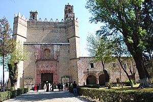
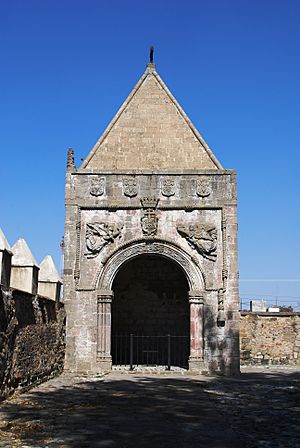
Facade of the monastery of San Miguel Arcángel
|
||
|
||
| Country | ||
| State | Puebla | |
| Founded | 1529 (Spanish settlement) | |
| Area | ||
| • Municipality | 188.91 km2 (72.94 sq mi) | |
| Elevation
(of seat)
|
2,260 m (7,410 ft) | |
| Population
(2005) Municipality
|
||
| • Municipality | 59,822 | |
| • Seat | 23,826 | |
| Time zone | UTC-6 (Central (US Central)) | |
| • Summer (DST) | UTC-5 (Central) | |
| Postal code (of seat) |
74160
|
|
| Area code(s) | 227 | |
| Website | Website | |
Huejotzingo is a city and municipality in central Mexico. It is located northwest of the city of Puebla. The area has a long history, going back to before the Spanish arrived. The modern city of Huejotzingo grew around a Franciscan monastery. This monastery was built in 1525. In 1529, the monks moved the local people to live near it. Today, Huejotzingo is known for making alcoholic apple cider and fruit preserves. It is also famous for its yearly carnival. This carnival is special because it acts out historical and legendary events. The biggest reenactment is about the Battle of Puebla. About 2,000 people dress up as French and Mexican soldiers and have pretend battles for four days.
Contents
Monastery of San Miguel Arcángel
The Franciscans built the monastery of San Miguel Arcángel in 1525. It was outside the old native settlement of Huejotzingo. This makes it one of the oldest monasteries in the Americas. It was also one of the first four Franciscan monasteries in New Spain. The monastery was named after the Archangel Michael. He later became the protector of the Spanish settlement of Huejotzingo. He is still the patron saint of the area today.
The building you see now is the third one built on this spot. The first was a simple building from 1524 to 1529. In 1529, the Franciscans, led by Juan de Alameda, moved the native people to live next to the monastery. Some say they did this because it was hard to climb to the old village. But it was probably to use the local people's help to build a bigger monastery. The first monastery was torn down. A second one was built between 1529 and 1539. This building also did not last. Only old plans and parts of its foundation were found in 1980.
The third and current monastery started in 1544 and finished in 1570. Juan de Alameda also led this construction. It ended when he died, and he was buried there. In the past, people said it was as grand as a famous church in Spain. It was also called one of the most beautiful in Mexico. The building has survived many earthquakes with little damage. In the 1990s, it became a World Heritage Site. This means it is a special place protected by the world. The state of Puebla promotes tours of the monastery. It is part of a "Franciscan Route" that links it to other old monasteries.
The monastery has an atrium with corner chapels. It also has a cloister and a main church. The whole complex is on a large, raised platform. A thick stone wall with merlons (castle-like tops) surrounds it. These merlons are also on the church and cloister walls. They look like designs from older native buildings. The thick walls and narrow windows made the monastery like a fortress. It protected the monks and later the local people from attacks.
The atrium faces west, towards the city's main plaza. You climb stairs to reach the atrium gate. It has three arches with decorations. The atrium is a large rectangle, sixty meters long. Its most beautiful parts are the four chapels in each corner. They were built around 1550. These chapels were used for religious parades. They also served as chapels for the many native people in the 1500s. They have fancy decorations, like the Franciscan coat of arms. In the middle of the atrium, there is a cross. Most stories say this cross is not the first one. It is made of sandstone and looks like two tree trunks.
The monastery also had a system of aqueducts. These brought water from the Xopanac River. You can still see parts of it today.
The church and monastery mix medieval and Renaissance styles. You can see Plateresque and Moorish designs. Plateresque means large, smooth areas with few decorations. This is seen on the church's front and north side. The church entrance has tall columns. The Moorish style is in the main door's arch.
Inside, the church has one main room called a nave. There are old paintings on the walls. The best ones show people in hoods, called "Los encapuchados." The main altar is one of the few from the 1500s left in Mexico. It was made by Simon Pereyns. Another special part is the stone design around the door to the sacristy. It has a crisscross pattern of flowers.
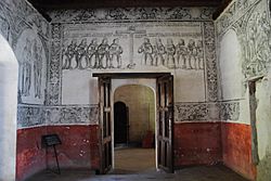
The entrance to the monastery area is on the south side. It has two wide arches. Inside, the cloister still has all its original parts. This includes a courtyard, fountain, monks' rooms, refectory (dining hall), kitchen, and gardens. There is also a meditation room called the sala de profundis. This room has the best-preserved wall paintings. One shows the first twelve Franciscans who came to Mexico. Today, this cloister is a museum. It has old artworks and items from the colonial period. It also explains how the Franciscans taught Christianity after the Spanish conquest.
Carnival of Huejotzingo
The carnival in Huejotzingo is very special. It is different from other carnivals in Mexico and around the world. Many visitors come to see it each year. About 35,000 people, from Mexico and other countries, attend. The people who dress up are local residents. They range from five years old to over fifty. Many families have been part of it for generations. All the costumes are made in the town. This includes special "Turkish" shoes and wooden muskets. The clothes are also decorated with care. Up to 10,000 people wear costumes for the event. A lot of gunpowder is used for the muskets over four days. Sometimes, accidents happen, leading to injuries.
Historically, this carnival is linked to old native festivals. These include celebrations for the god Tlaloc (rain god). It also connects to "flower wars" from long ago. In these wars, the goal was to capture warriors, not to kill them. The modern carnival officially started in 1869. It has been held every year since then.
Preparations for the carnival begin in January. There is a party with masked dancing and live music. This event is called desfiguros or los viejitos. The carnival officially starts the weekend before Ash Wednesday. On Saturday, a parade begins in the afternoon. The people in charge, called generals, go to the town hall. The town president signs a paper giving them control of the main plaza. Then, banners are hung around the city center to announce the carnival has begun.
For the next four days, people enjoy music and fireworks. But what makes this carnival unique are the reenactments. They act out three parts of the area's history and stories. These happen many times during the event.
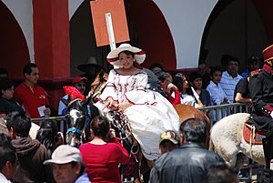
The first story is about Agustín Lorenzo. He was a bandit from long ago. Legend says he was in love with the daughter of the Corregidor (a Spanish official). In the reenactment, the woman playing the daughter goes to the town hall. She climbs to a balcony to be "kidnapped." The man playing Lorenzo arrives on horseback. He climbs a rope ladder to take her. They escape, and lawmen chase them on horses. People watching usually cheer for the bandit and his bride. As they leave, a small hut is burned in the main plaza. This is because it is said Lorenzo took the woman to his hut, and the Corregidor ordered it burned. The reenactment ends with Lorenzo and the daughter getting married by a priest. Lorenzo then becomes an honest man.
At the same time, another wedding happens on the other side of the plaza. This reenacts the first native couple to be married with Catholic traditions in the area. People believe it was the first of its kind in the Americas.
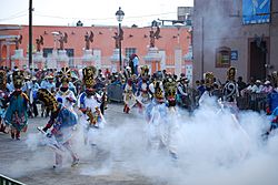
The biggest event is based on the Battle of Puebla. This battle happened in the 1800s between French and Mexican soldiers. For this, people from the city's four main neighborhoods form "battalions." Each battalion has a "general." For all four days, these battalions, about 2,000 people, have pretend battles. They fire their wooden muskets, filling the air with gunpowder smoke. During this time, the groups eat together. They also visit the graves of members who have passed away. About 30% of the participants are women. They dress and wear masks like men. Two battalions represent the French, and two represent the Mexicans. However, the uniforms are not exactly like the real historical ones. The "French" dress as Zouaves and "zapadores." Others dress as "Turks" with turbans. The Mexican side dresses as "serranos," "zacapoaxtlas," and "apaches" (with headdresses).
Each person pays a fee to take part. They also buy about four kilos of gunpowder. The generals hire bands that play for four days. Participants also spend a lot on their costumes. Some outfits can be very expensive, depending on the type and decorations. Everyone carries decorated wooden rifles or muskets.
The zacapoaxtla costume is a shirt with loose cotton pants. They are decorated with colorful stripes, sequins, and beads. It also includes white stockings and bags for ammunition. A leather mask with a beard made of real human hair completes the look. The traje serrano is a black cotton shirt and pants. It has an animal skin around the shoulders, a palm hat, and huarache sandals. If it has a native headdress and jewelry, it is called a traje de apache. A zapador outfit has a shirt, a short blue jacket, and red baggy pants. It also has an embroidered apron-like piece. The wearer has a hat and a mask with a mustache and beard. The "Turco" (Turkish) dress has a white shirt and pants, a small blue vest, and a turban with a peacock feather. It also includes a mask with a mustache and beard. They can also wear silk capes with pictures of Mexican heroes.
Tuesday is the most important day. Activities start very early, with groups gathering food and drinks. Around 6 AM, they eat breakfast. Then, they go to local cemeteries to honor dancers who have died. At noon, parades and other events happen, like on previous days. At 6 PM, the battalions are officially "dismissed." Then, the partying continues until midnight.
Children in the area love the carnival. You often see them in costumes with small rifles. The Sunday after Ash Wednesday is for a "Children’s Carnival." In this event, the use of fireworks and gunpowder is carefully controlled to keep children safe.
Economy in Huejotzingo
The area generally has a good economy. Only about one-third of its communities have a high level of economic hardship. The main economic activity in Huejotzingo is farming. After that comes industry. About 39% of the people work in agriculture, forestry, and fishing. The main crops are beans, wheat, alfalfa, walnuts, and fruits. These fruits include pears, plums, apricots, peaches, and tejocotes. The municipality has many fruit orchards. Much of this fruit is sold as preserves. Farmers also raise dairy cows, meat cattle, pigs, goats, sheep, horses, and chickens.
Forestry (cutting down trees) has become very small because of deforestation. There is a reservoir called San Joaquin and a pond called San Mateo that have fish. Trout are raised on farms along the Alseseca and Xopana rivers.
About 31% of the people in Huejotzingo work in manufacturing, mining, and construction. The traditional industries here are making alcoholic apple cider and fruit preserves and candies. Cider has been made in the municipality since 1920. There are five big cider factories. They make about 1.5 million bottles of cider each year. The city used to have many apple orchards around it. But building the airport destroyed most of them. Now, most apples for cider come from another area called Salvador El Seco.
The municipality has a growing industrial area called Quetzalcoatl. It is along Federal Highway 190. This area has four parts. The first part is for metals, machinery, construction, and food processing. The second and third parts are still empty land. There are plans for car parts factories there in the future. The fourth part is mainly for making medicines. Mining here is only for clay.
About 28% of the people work in tourism, shops, and services. Most shops serve local needs. But they also sell the area's famous cider and fruit preserves. The municipality gets tourists mainly because of the monastery and its museum. The annual carnival also brings many visitors.
History of Huejotzingo
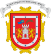
The name Huejotzingo comes from the Nahuatl language. It means "place of small willows." This is because the area used to have many willow trees growing in wet, marshy places. Huejotzingo received its coat of arms in 1553 from Carlos V. It shows a silver fortress on a red background. It has a blue flag with a gold Cross of Jerusalem. There is also a gold palm tree. Two lions stand on either side of the fortress. Around all of this is a border with five blue stars on a silver background. It also has the words "Carolus Quintus Hispaniarum Rex," which means "Charles V, King of the Spanish" in Latin.
This area, near the Iztaccíhuatl volcano, was first settled by groups like the Olmecs and Xicalacas. Later, Toltecs and Chichimecas lived here. First, there were many small villages. These then joined together to form a dominion (a ruled territory). Between the 1200s and 1300s, this dominion was at its strongest. It made agreements with other powerful areas like Tenochtitlan, Tacuba, and Texcoco. It also made agreements with Tlaxcala. With both these areas, it took part in the Xochiyaotl, or Flower Wars. These wars were to capture people for human sacrifice.
One story says that the ruler of Huejotzingo protected both Moctezuma Ilhuicamina and Nezahualcoyotl. They were being chased by the Tepanecas. When these two became rulers of Tenochtitlan and Texcoco, they never forgot the help. The old Huejotzingo settlement was on high ground near the Iztaccihuatl volcano. This was probably because of the good water supply and its easy-to-defend location. The area came under Aztec rule in the 1400s. But the people did not get along well with the Aztecs. When the Spanish arrived, Huejotzingo broke its ties with Tenochtitlan. The town decided to join the Spanish against the Aztecs in 1520.
After the Spanish Conquest, the area became the property of Diego de Ordaz. Soon after, it came under the direct control of the viceroy (a Spanish ruler). The Franciscans built a monastery in 1525. It was one of several important early monasteries. The head of this monastery, Juan de Alameda, moved the old native settlement of Huejotzingo. He resettled the people around the monastery, where the city is today. The new settlement was organized into four neighborhoods, one on each side of the monastery. The first public buildings were the "portales" (a commercial area) and a government building. A textile industry also started.
In 1560, the native community protested the yearly tax they had to pay. Even though a count showed 11,328 native people, the Spanish Crown demanded taxes for 25,000 people. However, the town lost and had to pay. Records of these high taxes were written in a book called the Chavero Codex of Huexotzingo in 1578. It was written in the Nahuatl language.
For much of its history, the area was ruled by powerful local leaders called caciques and caudillos. They ruled by force or political connections. This often stopped the area's economy from growing. The name de Nieva was added in 1861. This honored Ignacio Nieva, who died fighting in the Reform War era. The cemetery was built in 1899.
For most of the 1900s, the local presidents came from one political party, the Partido Revolucionario Institucional (PRI). They also came from two local families. These leaders did not want new factories or highways built. In November 1995, there was an election for municipal president. The candidates were Jesus Mensus from the PAN and Miguel Angel Martinez Escobar from the PRI. The PAN candidate got the most votes. But the PRI said there were problems at eleven voting places. The state election group canceled the votes from these places. This allowed the PRI to win by 28 votes. Supporters of Mensus then took over the town hall. Talks between the parties broke down. In May, the PAN and the protests led to a new look at the election. The PAN was then declared the winner.
Geography of Huejotzingo
Huejotzingo is on the slopes of the Sierra Nevada mountains. It is 25 km northwest of the capital city, on Highway 150. The land changes depending on how close it is to the Sierra Nevada. Areas below 2,500 meters above sea level on the far east side are part of the Valley of Puebla. Between 2,500 and 3,000 meters above sea level are the lower slopes of the Sierra Nevada. Above this, on the far west side, the land is part of the mountain range and the Trans-Mexican Volcanic Belt.
The east side of the municipality is flat. Going west, the land slowly rises in the middle. Then, the altitude increases sharply on the west end. This is because it is at the foot of the Iztaccíhuatl volcano. Near this volcano, there are other hills like Ocotepec and Tepechichipa. The Iztaccíhuatl volcano is very steep. This means it can have rockslides when snow melts and runs down its side. This happens especially from a dip on the side where snow collects, called Ayolócotl. You can see areas on the volcano without plants. These are where rockslides have damaged the environment.
Hydrography (Waterways)
The municipality is in the upper part of the Atoyac River basin. This is one of the most important river areas in the state. The Atoyac River starts where Mexico State and Puebla meet. Rivers and streams here generally flow from southwest to northwest. They come from the Sierra Nevada and all flow into the Atoyac. These include the San Diego, Cuaxupila, Alseseca, and Xopanac rivers. Some of these rivers have less water now because of deforestation. Today, the Xopana River is mostly dry and has garbage in some places. Some rivers have cut deep ravines and small canyons into the land. The melting snow from the volcanoes feeds most of these streams and rivers. Water and snow stored in dips on the mountain keep the rivers flowing during the dry season. Also, rain and snowmelt fill underground water sources and freshwater springs.
Climate
The municipality has three climate zones. The lower valley areas have a mild, somewhat humid climate with summer rains. A somewhat cold and semi-humid climate with summer rains is found at the foot of the Sierra Nevada. On the higher slopes of the volcano, the climate is cold.
Flora (Plants)
Plants also grow in three zones. The low, flat areas are used for farms and cities. The foothills usually have forests of pine, holm oak, and oyamel trees. There are also areas of brush. But much of this land is being cleared for new farms. The higher slopes of Iztaccíhuatl have snowy, rocky land with areas of alpine meadow.
The Municipality of Huejotzingo
The small city of Huejotzingo is the main governing center for over a hundred other communities. These communities cover an area of 188.91 square kilometers. The municipality is in the center-west of the state, bordering the State of Mexico. It shares borders with other municipalities like San Salvador el Verde and San Martín Texmelucan. Other important communities in the municipality include Santa María Atexcal and San Mateo Capultitlan. There are local government offices in several communities.
Festivals include the Feria Regional de Huejotzingo in September. There is also the Feria del Santuario de la Preciosa Sangre. This happens on the fourth Friday of Lent in Santa Ana Xalmimilulco. Other communities celebrate their patron saints' feast days. For example, Santa Ana Xalmimilulco celebrates on July 26.
Just under 40% of the total population of 59,822 lives in the city itself. Since 1995, the municipality's population has grown by about 2.77%. Most people are Roman Catholic. The next largest group, Evangelical/Protestant, makes up 4.4% of the population. There are some Nahua families. In 2005, 725 people spoke an indigenous language.
Education
The municipality has 25 preschools, 21 primary schools, ten middle schools, and four high schools. There is also a CECATI technical and vocational school. There is one major university called the Universidad Tecnológica de Huejotzingo. It was started in 1998 in the community of Santa Ana Xalmimilulco. This university mainly offers degrees in technology. These include mechanical engineering, information technology, project management, and textile design.
Transportation
The International Airport of Puebla is located in the municipality. It is 20 minutes by highway from Puebla city. It is an hour from Mexico City. Its full name is Aeropuerto Internacional de Puebla Hermanos Serdán. The airport opened in 1985. It is one of Mexico's newer airports. It mainly serves the Puebla and Tehuacán areas. Most flights are within Mexico. Some international flights go to the United States. In 2009, it served 550,000 passengers. The main airline here is Volaris. In total, six airlines offer flights to cities like Monterrey, Guadalajara, and Tijuana. They also fly to Houston and Dallas in the U.S. Buses and taxis connect the airport to Puebla city. You can also rent cars. There is parking for 230 cars, but no hotel at the airport.
See also
 In Spanish: Huejotzingo para niños
 | Emma Amos |
 | Edward Mitchell Bannister |
 | Larry D. Alexander |
 | Ernie Barnes |


