Rochester metropolitan area, Minnesota facts for kids
Quick facts for kids
Rochester, Minnesota MSA
|
|
|---|---|

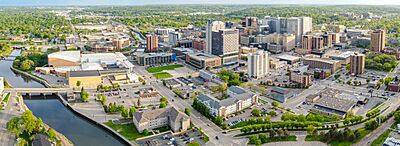
Rochester, Minnesota skyline
|
|
 |
|
| Country | |
| States | |
| Principal cities | Rochester |
| Area | |
| • Metro | 2,507 sq mi (6,490 km2) |
| Population
(2021)
|
|
| • MSA | 227,151 |
| • CSA | 267,309 |
| Time zone | UTC−6 (CST) |
| • Summer (DST) | UTC−5 (CDT) |
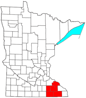
The Rochester, Minnesota Metropolitan Statistical Area (MSA) is a special area in southeast Minnesota. It's like a big neighborhood that includes the city of Rochester and five nearby counties. The United States Census Bureau defines these areas to help understand how people live and work together across cities and their surrounding communities.
As of 2018, about 221,587 people lived in the Rochester metropolitan area. There's also a larger area called the Rochester–Austin combined statistical area. This bigger area includes even more communities and had about 259,813 people in 2018.
Contents
Counties in the Area
The Rochester MSA includes five counties. These counties work together to form the metropolitan area.
Communities in the Rochester Area
The Rochester metropolitan area is home to many different cities and towns. The main city is Rochester, which is the largest.
Cities
- Rochester: This is the biggest city in the area, with over 100,000 people. It's the main center for jobs and activities.
- Other Cities: Many other cities are part of the MSA. Some of the larger ones include Byron, Chatfield, Dodge Center, Kasson, Lake City, Pine Island, Plainview, Stewartville, and Wabasha.
- Smaller Towns: There are also many smaller towns and villages. These places have fewer people but are still important parts of the community. Examples include Eyota, Preston, and Spring Valley.
Unincorporated Places
Some places in the area are not officially cities or towns. They are called "unincorporated places." These are smaller communities without their own local government. Examples include Douglas and Simpson.
Population and People
Understanding the people who live in an area helps us learn about its culture and needs. The last full count of people, called a census, was in 2000.
In 2000, there were 163,618 people living in the Rochester MSA. These people lived in 62,504 households, which are like homes or families. About 43,046 of these were families.
Most people in the area were White (92.01%). There were also people who identified as African American (2.09%), Asian (3.34%), and other groups. About 2.35% of the population was Hispanic or Latino.
The average income for a household in 2000 was about $46,957 per year. For families, the average income was around $55,450. This information helps us understand the economic health of the area.
Getting Around: Transportation
Good transportation helps people travel for work, school, and fun. The Rochester MSA has many roads and airports.
Highways
Highways are major roads that connect cities and states.
Interstate Highways
US Highways
 U.S. Highway 14
 U.S. Highway 52
 U.S. Highway 61
 U.S. Highway 63
 U.S. Highway 218 (This highway briefly goes through Dodge County.)
Minnesota State Highways
These highways are managed by the state of Minnesota.
 Minnesota State Highway 16
 Minnesota State Highway 30
 Minnesota State Highway 42
 Minnesota State Highway 43
 Minnesota State Highway 44
 Minnesota State Highway 56
 Minnesota State Highway 57
 Minnesota State Highway 60
 Minnesota State Highway 74
 Minnesota State Highway 80
 Minnesota State Highway 139
 Minnesota State Highway 247
 Minnesota State Highway 250
Public Airports
Airports allow people to travel by plane.
Commercial Airports
- Rochester International Airport: This airport offers flights to and from other major cities.
General Aviation Airports
These airports are usually for smaller, private planes.
- Dodge Center Airport
- Fillmore County Airport
- Rushford Municipal Airport
See also
 In Spanish: Área metropolitana de Rochester (Minnesota) para niños
 | Delilah Pierce |
 | Gordon Parks |
 | Augusta Savage |
 | Charles Ethan Porter |

