Dodge County, Minnesota facts for kids
Quick facts for kids
Dodge County
|
|
|---|---|

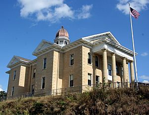
Dodge County Courthouse
|
|

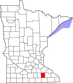
Location within the U.S. state of Minnesota
|
|
 Minnesota's location within the U.S. |
|
| Country | |
| State | |
| Founded | February 20, 1855 |
| Named for | Henry Dodge |
| Seat | Mantorville |
| Largest city | Kasson |
| Area | |
| • Total | 440 sq mi (1,100 km2) |
| • Land | 439 sq mi (1,140 km2) |
| • Water | 0.3 sq mi (0.8 km2) 0.07%% |
| Population
(2020)
|
|
| • Total | 20,867 |
| • Estimate
(2023)
|
21,088 |
| • Density | 47.5/sq mi (18.3/km2) |
| Time zone | UTC−6 (Central) |
| • Summer (DST) | UTC−5 (CDT) |
| Congressional district | 1st |
Dodge County is a place in Minnesota, a state in the United States. In 2020, about 20,867 people lived here. The main town, or county seat, is Mantorville. Dodge County is also part of the larger Rochester area.
Contents
History of Dodge County
Long ago, the land that is now Dodge County was used for hunting and battles. The Mdewakanton Sioux people lived here. They sometimes fought with the Sauk and Fox Indians who came into their area.
Around 1655, a French fur trader from Canada might have been the first non-Native person to visit. Later, settlers from New England came to live here. Many people moved to the area in the 1820s and 1830s. This was easier because the Erie Canal was finished in 1825. Also, the Black Hawk War ended in 1831, making the area safer.
These early settlers cared a lot about education. They started many schools. They also strongly supported ending slavery, which was called abolitionism. In 1853, government workers mapped out the land into townships. In 1854, the Mantor brothers and Eli P. Waterman settled in the area of what is now Mantorville.
In early 1855, Dodge County was officially set up for local government. It was named after Henry Dodge. He was the first governor of Wisconsin from 1836 to 1841.
On May 11, 1858, Dodge County became part of Minnesota's Fifth Judicial District. The county courthouse was built in 1865. It is still used today and is the oldest courthouse in Minnesota. As the 1900s began, more people came to Minnesota from Germany, Sweden, and Norway. They brought new cultures and religions, like Catholic and Lutheran faiths.
Geography and Nature
Dodge County is in southeastern Minnesota. It is about 24 miles (39 km) long and 18 miles (29 km) wide. The Zumbro River flows through the middle of the county. Other creeks like Salem Creek and Harkcom Creek also cross the land.
The county has rolling hills, which means gentle slopes. Farmers use much of this land for growing crops. The land slopes down towards the northeast. The highest point is about 1,352 feet (412 meters) above sea level.
The central and northern parts of the county have hills and many trees. The soil here is loose and has pebbles, which is good for growing wheat. The southern part is flat and wet. This land is better for raising animals like cattle. The soil in the south is very rich and dark.
Dodge County is one of seven counties in southern Minnesota that do not have large forests. Instead, it has mostly prairie and savanna lands. These are open grasslands with some scattered trees.
The county also has a lot of sand and rock. This makes it a good place for building materials. Quarries in Mantorville used to be busy places. They had thick layers of stone that could be cut into different shapes. The town of Wasioja is known for its excellent "Wasioja stone."
Streams
- Dodge Center Creek
- Harkcom Creek
- Henslin Creek
- Little Cedar River
- Masten Creek
- Millikin Creek
- Salem Creek
- Tompkins Creek
Lakes
- Rice Lake (part)
- Zumbro River Reservoir
Major Roads
Airport
- Dodge Center Municipal Airport
Neighboring Counties
- Rice County - northwest
- Goodhue County - northeast
- Olmsted County - east
- Mower County - south
- Steele County -west
Population Information
The population of Dodge County has changed over the years. Here's how it has grown:
| Historical population | |||
|---|---|---|---|
| Census | Pop. | %± | |
| 1860 | 3,797 | — | |
| 1870 | 8,598 | 126.4% | |
| 1880 | 11,344 | 31.9% | |
| 1890 | 10,864 | −4.2% | |
| 1900 | 13,340 | 22.8% | |
| 1910 | 12,094 | −9.3% | |
| 1920 | 12,552 | 3.8% | |
| 1930 | 12,127 | −3.4% | |
| 1940 | 12,931 | 6.6% | |
| 1950 | 12,624 | −2.4% | |
| 1960 | 13,259 | 5.0% | |
| 1970 | 13,037 | −1.7% | |
| 1980 | 14,773 | 13.3% | |
| 1990 | 15,731 | 6.5% | |
| 2000 | 17,731 | 12.7% | |
| 2010 | 20,087 | 13.3% | |
| 2020 | 20,867 | 3.9% | |
| 2023 (est.) | 21,088 | 5.0% | |
| U.S. Decennial Census 1790-1960 1900-1990 1990-2000 2010-2020 |
|||
2020 Census Details
The 2020 census showed the different groups of people living in Dodge County:
| Race | Number of People | Percentage |
|---|---|---|
| White (not Hispanic) | 18,807 | 90.13% |
| Black or African American (not Hispanic) | 126 | 0.6% |
| Native American (not Hispanic) | 37 | 0.2% |
| Asian (not Hispanic) | 104 | 0.5% |
| Pacific Islander (not Hispanic) | 1 | 0.01% |
| Other/Mixed (not Hispanic) | 735 | 3.5% |
| Hispanic or Latino | 1,057 | 5.1% |
Towns and Areas
Dodge County has several cities and smaller communities.
Cities
- Blooming Prairie (partly in Steele County)
- Claremont
- Dodge Center
- Hayfield
- Kasson
- Mantorville (county seat)
- West Concord
Unincorporated Communities
These are smaller places that are not officially cities.
Townships
Townships are smaller local government areas.
- Ashland Township
- Canisteo Township
- Claremont Township
- Concord Township
- Ellington Township
- Hayfield Township
- Mantorville Township
- Milton Township
- Ripley Township
- Vernon Township
- Wasioja Township
- Westfield Township
See also
 In Spanish: Condado de Dodge (Minnesota) para niños
 | Janet Taylor Pickett |
 | Synthia Saint James |
 | Howardena Pindell |
 | Faith Ringgold |

