Claremont, Minnesota facts for kids
Quick facts for kids
Claremont
|
|
|---|---|

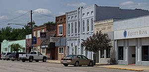
Buildings in downtown Claremont
|
|
| Motto(s):
"City On The Right Track"
|
|

|
|
| Country | United States |
| State | Minnesota |
| County | Dodge |
| Government | |
| • Type | Mayor–Council |
| Area | |
| • Total | 1.08 sq mi (2.79 km2) |
| • Land | 1.08 sq mi (2.79 km2) |
| • Water | 0.00 sq mi (0.00 km2) |
| Elevation | 1,286 ft (392 m) |
| Population
(2020)
|
|
| • Total | 513 |
| • Density | 476.32/sq mi (183.84/km2) |
| Time zone | UTC-6 (Central (CST)) |
| • Summer (DST) | UTC-5 (CDT) |
| ZIP code |
55924
|
| Area code(s) | 507 |
| FIPS code | 27-11566 |
| GNIS feature ID | 2393531 |
Claremont is a small city in Dodge County, Minnesota, in the United States. It's located in southeastern Minnesota, along U.S. Highway 14. Claremont is part of the larger Rochester area. In 2020, about 513 people lived there.
Claremont started in the mid-1800s as a farming town. The Chicago & North Western Railway helped it grow by making it easier to transport farm goods. The city officially became a city in 1878. For many years, it has been a center for the farms around it. In 1990, Claremont's school joined with schools from Dodge Center and West Concord to form the Triton Public Schools district. Today, Claremont is still a small town. It provides important services to its residents and the farms nearby.
Discovering Claremont: Location and Size
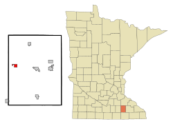
Claremont is a small city in Dodge County. You can find it in the southeastern part of Minnesota. It's considered part of the Rochester area. The city sits right along U.S. Route 14. This highway makes it easy to get to Rochester, which is about 18 miles away. Rochester is the biggest city nearby. You can also reach Claremont using Dodge County Road 1 and Dodge County Road 3. These roads connect it to other towns and highways.
How Big is Claremont?
Claremont covers about 1.08 square miles (2.79 square kilometers) of land. This is a pretty small area. For example, the city of Minneapolis in Minnesota is much larger, covering about 58.4 square miles. Claremont is a great example of a smaller, close-knit community.
Claremont's Neighbors
Claremont is in Dodge County. Its neighbors include Dodge Center to the north and West Concord to the south. As mentioned, Rochester is about 18 miles to the southeast. Rochester is famous for its healthcare and education, especially the Mayo Clinic. Even though Claremont is near a big city, it keeps its quiet, small-town feel.
What Does the Land Look Like?
Claremont is part of the Minnesota Prairie and the driftless area of southeastern Minnesota. The land around the city is mostly flat or gently rolling. This is common for this part of Minnesota. Farms surround Claremont, and you might see some small hills and scattered wooded areas.
Water Around Claremont
Claremont isn't right next to a huge river or lake. However, it's in an area with several rivers and streams in Dodge County. The most well-known is the Zumbro River, which flows to the east. The Zumbro River offers some chances for local water fun. Claremont itself doesn't have big ports or waterways for large boats.
How High is Claremont?
Claremont is about 1,286 feet (392 meters) above sea level. The land in and around Claremont is mostly flat farmland. You'll also see gentle hills and small streams flowing through the area.
Natural Resources in the Area
The land around Claremont is very good for farming. The soil is fertile, which means it's great for growing crops. This Minnesota Prairie region grows many crops like corn, soybeans, and wheat. Farmers also raise animals here. So, the main natural resources are the farm products, not minerals or other materials.
Roads and Railways
Claremont has good roads that connect it to bigger cities:
- U.S. Highway 14 is the main road. It links Claremont to Rochester and other nearby towns.
- Dodge County Road 1 and Dodge County Road 3 are local roads. They help people get around the surrounding areas. The Dodge County Highway Department takes care of these roads.
Claremont doesn't have a rail line anymore. But in the past, the Chicago & North Western Railway served the area. This railway was very important in the late 1800s. It helped Claremont become a key place for trading farm goods. Trains were vital for the region's economy back then.
Claremont's Climate
Claremont has a humid continental climate. This means it has four clear seasons:
- Winters are cold. Temperatures often drop below freezing, and it snows a lot.
- Summers are warm and humid. Temperatures often reach the 80s and 90s °F (27-37°C).
- Spring and fall are in-between seasons. They have mild temperatures and a good amount of rain.
Temperatures can change a lot between seasons. Summer highs can be over 90°F (32°C). Winter lows can go below 0°F (-18°C). Rain falls throughout the year, but spring and summer get the most. Summers are humid, while winters are drier.
Weather Surprises
- Summer thunderstorms can bring heavy rain. Sometimes, tornadoes can happen in the region. Claremont is in Tornado Alley, so tornado warnings are possible in summer.
- Snowfall can be heavy in winter, usually from November to March. On average, about 30 inches (76 cm) of snow falls each year.
- Sometimes, the area can have drought conditions. But usually, there's enough rain for farming.
Local Economy and Industry
Claremont is mainly a farming community. However, it benefits from being close to the Rochester area. Rochester is a big center for healthcare and biotechnology. The famous Mayo Clinic in Rochester helps the economy of nearby places like Claremont. The local economy in Claremont is supported by small-scale manufacturing, healthcare, and construction businesses.
Claremont's Past: A Brief History
Claremont, in southeastern Minnesota, was settled in the mid-1800s. Its growth was first shaped by the good farming land and its location near important transportation routes. These routes included railroads and highways. The Chicago and North Western Railway was very important in Claremont's early days. It helped the city become a center for trading farm products. In 1878, the city officially became incorporated. From then on, it steadily grew as a small farming community, serving the people who lived on the surrounding farms.
Who Influenced Claremont's Growth?
The main influences on Claremont's development came from the state and federal governments. They helped build important things like roads and railways. These helped the city grow. The expansion of the Chicago and North Western Railway across the Midwest connected Claremont to bigger markets. This boosted its economy. The railroad era also shaped how the city was settled and how its economy worked. Minnesota's farming policies also encouraged farming and rural development in the area.
Claremont and Major Historical Events
Claremont's history has not been greatly changed by wars or treaties. The area was first home to Indigenous peoples. Then, European Americans settled there in the mid-1800s. There are no specific records that show major land divisions or changes because of wars or treaties. However, the larger story of the United States expanding westward did affect how communities like Claremont developed.
See also
 In Spanish: Claremont (Minnesota) para niños
 | Tommie Smith |
 | Simone Manuel |
 | Shani Davis |
 | Simone Biles |
 | Alice Coachman |

