Roosevelt Island facts for kids
|
Minnehanonck / Varken Eylandt ("Hog Island") / Manning's Island / Blackwell's Island / Welfare Island
|
|
|---|---|
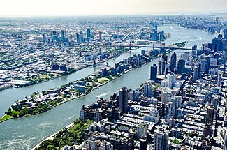
Seen in July 2017 looking southward
|
|
| Geography | |
| Location | East River, Manhattan, New York, United States |
| Coordinates | 40°45′41″N 73°57′03″W / 40.76139°N 73.95083°W |
| Area | 0.23 sq mi (0.60 km2) |
| Length | 2 mi (3 km) |
| Width | 0.15 mi (0.24 km) |
| Highest elevation | 23 ft (7 m) |
| Administration | |
|
|
|
| State | |
| City | New York City |
| Borough | Manhattan |
| Demographics | |
| Population | 11,722 (2020) |
| Pop. density | 50,965 /sq mi (19,677.7 /km2) |
| Ethnic groups | 36.3% white, 10.6% black, 12.3% Hispanic, 33.2% Asian or Pacific Islander, and 7.0% other races (as of 2020) |
Roosevelt Island is a long, narrow island in New York City's East River. It sits between Manhattan to the west and Queens to the east. The island is about 2 miles (3.2 km) long and covers about 147 acres (0.59 km²). In 2020, about 11,722 people lived there.
The island has two main neighborhoods: Northtown and Southtown. New York City owns Roosevelt Island, but it has been leased to the New York State Urban Development Corporation (UDC) since 1969.
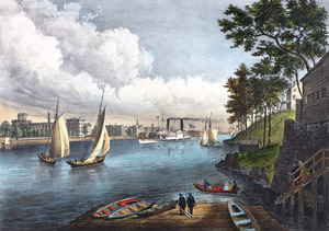
Over time, the island has had many names. The Lenape people called it Minnehanonck. The Dutch, who were early European settlers, called it Varken Eylandt, meaning "Hog Island". Later, it was known as Manning's Island and then Blackwell's Island. For much of the 1800s and 1900s, the island was home to hospitals and prisons. It was renamed Welfare Island in 1921.
In the 1960s, there were plans to develop the island. In 1973, it was renamed Roosevelt Island after former U.S. President Franklin D. Roosevelt. New homes were built, starting with Northtown in 1974 and Northtown II in 1989. Southtown was developed in the early 2000s, along with the Cornell Tech university campus.
Besides homes, Roosevelt Island has older buildings, including six that are famous landmarks. You can get to the island by a bridge, a cable car, the subway, and ferry. The island has its own post office and a special system for collecting garbage. There are also several parks, including a path around the island and Four Freedoms Park at its southern end. The island has an elementary school and places of worship. Many community groups have also started there.
Contents
Island Geography
Roosevelt Island is right in the middle of the East River. It is located between Manhattan Island on the west side and Queens on the east side. The island's southern tip is across from 47th Street in Manhattan. Its northern tip faces 86th Street in Manhattan.
The island is about 2 miles (3.2 km) long. Its widest point is about 800 feet (240 m). The island was smaller before the 1700s, but it has been expanded to 147 acres (0.59 km²). Roosevelt Island is part of the Manhattan area of New York City.
The island sits on a type of rock called Fordham gneiss. This rock is also found in the South Bronx. Over time, the East River's currents shaped the island by wearing away softer rock. The island's natural shape has changed a lot since the 1800s. More land has been added to make it bigger.
The main road on Roosevelt Island is Main Street. It runs the entire length of the island. Main Street was the only road until 1989 and is paved with red brick. This street and the island's parks were designed to be a shared space for everyone. Most of the homes and businesses are located near Main Street. A stone wall made from Fordham gneiss surrounds the island.
Island History
Early Days
Native American Use
People lived around Roosevelt Island as far back as 12,000 years ago. The Mareckawick, a group of Lenape Native Americans, lived here. They called the island Minnehanonck, which means "long island" or "It's nice to be on the island".
The Lenape likely visited the island. They had settlements near waterways. However, the island probably did not have permanent settlements because it lacked fresh water.
Dutch Settlers
When Europeans came in the 1600s, the Dutch took over the area. Dutch Governor Wouter van Twiller may have bought the island from the Lenape in 1637. The island was known in Dutch as Varken Eylandt, or Hog Island.
By 1639, a farmer named Jan Claessen Alteras farmed Hog Island. In 1642, New Netherland director-general Peter Stuyvesant took control of the island. It was then leased to other people who built more structures.
Manning and Blackwell Families
In 1664, the British took over from the Dutch. A British captain named John Manning got the island in 1668. He was later exiled to the island. After this, it was called Manning's Island.
Manning's stepdaughter, Mary, inherited the island. She married Robert Blackwell, who became the new owner. The island then became known as Blackwell's Island. The Blackwell family lived on the island for four generations. Around the early 1700s, Blackwell built his farmhouse, the Blackwell House. This is one of Manhattan's oldest houses.
Blackwell's Island was not a major battle site during the American Revolutionary War. British troops tried to take it in 1776 but were only there for a few days. By the 1780s, the island had two houses, orchards, and farm buildings. The family tried to sell the island in 1785 but found no buyers.
Hospitals and Prisons
By 1826, the city's poorhouse at Bellevue Hospital was too crowded. So, the city bought Blackwell's Island for $32,000 in 1828. For the next century, the island was used for hospitals and prisons. At one point, there were 26 different institutions there.
Mid-1800s
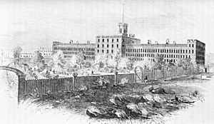
The city built a penitentiary on the island, which opened in 1830. A separate building was made for female prisoners. By 1838, hundreds of prisoners were on the island. In 1839, the New York City Lunatic Asylum opened, including the famous Octagon Tower. This asylum held many patients, sometimes twice its planned size.
Homes for the poor were built in 1847. Other hospitals followed, including a large prison hospital in 1849. The Asylum burned down in 1858 but was rebuilt. In 1860, fresh water pipes were added to the island. City Hospital opened in 1861, serving both prisoners and poor New Yorkers. A hospital for long-term patients opened in 1866.
Late 1800s
Prisoners built the Blackwell Island Lighthouse at the island's northern tip in 1872. A School of Nursing opened in 1877, one of the first in the country.
Conditions in some hospitals became very poor. The island gained a bad reputation. Patients from the Smallpox Hospital moved to North Brother Island in 1885. The Smallpox Hospital building became a nursing school. The Chapel of the Good Shepherd opened in 1889.
The Strecker Memorial Laboratory was built in 1892 for the City Hospital. By the 1890s, the almshouse and City Hospital were old and crowded. The asylum's patients moved to Wards Island. The Metropolitan Hospital moved to Blackwell's Island. By the end of the century, 7,000 people lived on the island in seven different institutions.
Early 1900s
By the 1900s, Blackwell's Island was sometimes called "Farewell Island" because of its sad reputation. It held a poorhouse, the city jail, and several hospitals. The Queensboro Bridge opened in 1909, crossing over Blackwell's Island. However, it did not provide direct access to the island until later.
By the 1910s, thousands of prisoners passed through the island's jail each year. The jail was very crowded and unsanitary. There were talks about moving the prison to Hart Island. This would free up Blackwell's Island for hospitals. The island's penitentiary was hurting the reputation of its other facilities. People started discussing renaming the island.
1920s and 1930s
In 1921, the city began using Blackwell's Penitentiary for women awaiting trial. The prison hospital was understaffed. In April 1921, the New York City Board of Aldermen renamed Blackwell's Island to Welfare Island. They hoped this new name would improve the island's image.
The city planned to move Welfare Island's prisoners to a new jail on Rikers Island. The Welfare Island prison was old and had rat problems. After the Rikers Island jail opened, the Welfare Island jail was torn down. All prisoners had moved by 1936.
In 1936, the city announced plans for a hospital for long-term care. The Welfare Island Hospital for Chronic Diseases, later Goldwater Memorial Hospital, opened in 1939.
1940s to 1960s
In the 1940s, plans were made for new hospital buildings and a nurses' training school. A girls' shelter opened in 1945. By the late 1940s, some of the island's hospitals were in very bad condition due to their age.
The Welfare Island Bridge to Queens opened in May 1955. A bus service then started on the island. The Metropolitan Hospital moved to Manhattan later that year. The City Hospital was replaced by a new hospital in Queens.
By 1960, half of Welfare Island was empty. Only the Goldwater and Bird S. Coler hospitals remained. The city tried to get money to tear down the abandoned buildings. The New York City Fire Department (FDNY) opened a training school in 1962. They used 90 abandoned buildings for practice.
Redevelopment Plans
Early Ideas
In 1961, a businessman named Frederick W. Richmond suggested building homes for 70,000 people on the island. Other ideas included turning the island into a park or housing for United Nations staff. Some plans suggested a college campus or a smaller residential area.
In 1965, a New York City Subway station was planned for Welfare Island. This led to more ideas for developing the island. People wanted to rename Welfare Island because its name was linked to hospitals and prisons.
The city started tearing down old buildings in 1965. In 1967, the state government suggested turning most of the island into a park. Other ideas included an amusement park, an underground nuclear power plant, or a "city of the future".
Johnson and Burgee's Plan
In 1968, Mayor John V. Lindsay formed a committee to plan the island's future. The state government created the Welfare Island Development Corporation (WIDC). In 1969, Lindsay asked the New York State Urban Development Corporation (UDC) to help. The city and state presented their plan in October 1969. The UDC then leased the island for 99 years.
Architects Philip Johnson and John Burgee designed the master plan. It included two neighborhoods, Northtown and Southtown, with a shared central area. The island was planned to be a car-free area with apartments, stores, and parks. There would be a hotel, schools, and offices. Many existing buildings would be kept. The plan also included a special system for collecting trash using air tubes.
The UDC changed some of the designs after they were shown to the public. For example, they added more buildings along the waterfront. Some people worried that the project was too expensive.
Island Redevelopment
Renaming and Northtown
The first part of the development, Northtown, was designed for about 2,100 families. Work officially began in 1971. The UDC hired many companies to design the buildings. In 1972, the UDC decided to build the homes as housing cooperatives.
The UDC thought about renaming the island to attract new residents. The Four Freedoms Foundation suggested naming it after President Franklin D. Roosevelt. The City Council approved the name change in July 1973. Welfare Island became Roosevelt Island on August 20, 1973. Plans for the Franklin D. Roosevelt Four Freedoms Park also began.
By mid-1973, one building was finished. The island was also made bigger using dirt from the 63rd Street Tunnel construction. Construction continued through 1974, and apartments became available that October. The old Blackwell House and Chapel of the Good Shepherd were also fixed up.
In 1975, residents started moving into the first building. At first, there were no stores on the island. People had to go through Queens to buy things. By the end of 1975, 170 families lived on the island. The first four Northtown buildings were finished by mid-1976.
Northtown II Development
No new buildings were finished between 1976 and 1989. This was due to delays in the subway line and the city's money problems. The Roosevelt Island Tramway to Manhattan opened in May 1976. It was meant to be a temporary way to get to the island until the subway opened.
By early 1977, over 3,000 people lived on the island. By 1978, there were 5,500 residents. Most of the rental apartments were full. In 1977, the UDC leased land to the Starrett Corporation. Starrett planned to build three more buildings with 1,000 apartments. These buildings were called Northtown II.
The opening of the subway was delayed many times. This worried residents, who also feared that the subway might cause crime to increase. By then, the island had 5,000 residents and 1,800 hospital patients. But there were not many businesses. In 1984, the state created the Roosevelt Island Operating Corporation (RIOC) to manage the island.
Work on Northtown II began in late 1987. The Northtown II towers, known as Manhattan Park, opened in 1989. These new apartments sold slowly at first. But by early 1990, 70 percent of them were occupied.
1990s Changes
The Roosevelt Island subway station opened in late 1989. This allowed more development to happen. Plans for the Southtown area were announced in October 1989. It would have 1,956 apartments. The city approved the Southtown plans in 1990. However, the project was put on hold by 1991. RIOC could not find a company to build it. For most of the 1990s, no large buildings were completed on Roosevelt Island.
The island's population remained lower than expected. RIOC worked to attract visitors. They built parks and tried to fix up the island's oldest buildings. In 1997, RIOC suggested selling the Southtown site. The Related Companies and Hudson Companies agreed to develop Southtown. The plans for Southtown were changed. They included new buildings and recreational fields.
A 26-story hotel was proposed in 1998, but this was a debated idea. There was also growing unhappiness with RIOC. Mayor Rudy Giuliani suggested the city take over the island in 1999. A company was hired to build the first part of Southtown in May 1999.
2000s to Today
By 2000, Roosevelt Island had 9,520 people. Some of the island's original affordable housing was planned to become market-rate housing. Southtown's first buildings were finished in 2002. A plan to turn the Octagon tower into an apartment building was also announced.
Southpoint Park, which was hard to get to, opened year-round in 2003. The island's first two condominium buildings, both in Southtown, and the Octagon were developed next. All three were finished by 2007. This increased the island's population to about 12,000. Southtown's fifth and sixth buildings were finished by 2008.
Work began on Four Freedoms Park in 2009. Southpoint Park reopened in 2011. Four Freedoms Park was finished in 2012. In 2011, the city chose Technion – Israel Institute of Technology and Cornell University to build the Cornell Tech research center on the island. This campus replaced the old Goldwater Memorial Hospital, which closed in 2013. Cornell Tech opened in 2017.
The island's population grew to 11,661 by 2010. The seventh Riverwalk building was finished in 2015, and the eighth in 2019. RIOC announced an "art trail" around the island in 2018. In 2019, RIOC started planning a memorial to journalist Nellie Bly. The The Girl Puzzle monument was dedicated in December 2021. The last building in Southtown, Riverwalk 9, began construction in 2022. In 2024, plans for a "healing forest" at the island's southern end were announced.
Island Community
Roosevelt Island's redevelopment in the 1970s created a unique community. One writer in 1989 called the island a "small, self-contained, family-oriented community". It had its own Little League Baseball team, newspaper, and library. Another article said it felt like a small town but was still close to Manhattan.
Many volunteer groups have started on the island. These include the Roosevelt Island Garden Club and a farmer's market. There are also groups like the Roosevelt Island Visual Art Association and the Main Street Theatre & Dance Alliance. The Roosevelt Island Historical Society keeps old records about the island. The island has a newspaper called The Main Street Wire, which started in 1981.
Roosevelt Island has many community traditions. These include Halloween parades, Black History Month events, and Lunar New Year celebrations. The island hosts picnics, concerts, and annual Roosevelt Island Day celebrations. It has also been a filming location for movies like Spider-Man (2002).
Island Buildings

The 1969 plan divided the island into two neighborhoods: Northtown and Southtown. The design received mixed reviews. Most of the homes are rental apartments, but there are also condominiums and cooperative housing. Roosevelt Island has more homes that are easy for people in wheelchairs to access. This is partly because it used to be a hospital island.
Northtown Buildings
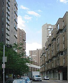
Northtown was the first part of Roosevelt Island to be developed. It has about 2,140 apartments. Northtown includes four housing complexes: Westview, Island House, Rivercross, and Eastwood. These buildings are U-shaped and up to 20 stories high. They are made of concrete or corrugated brick.
Three of the buildings were rental apartments: Island House, Westview, and Eastwood. Eastwood had affordable housing. Rivercross was a housing cooperative. Most of these buildings were part of a state program for affordable housing. The apartments had heating and air-conditioning. The buildings also had health clubs.
Northtown II, also known as Manhattan Park, is north of Northtown. It was finished in 1989 and has five buildings. This complex has about 1,100 rental apartments. About 220 of these are affordable homes. The complex also has a garden, picnic area, community center, playgrounds, and a daycare. Near the north end of the island is the Octagon. This 500-unit apartment building is built around a part of the old Lunatic Asylum.
The northern part of Roosevelt Island also has the former church of the Metropolitan Hospital. It was built in the 1920s and became a wedding place in 2021.
Southtown and Southern End
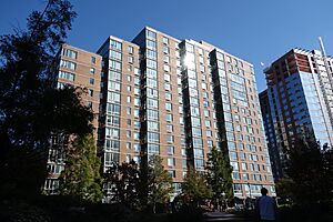
Southtown, also called Riverwalk, started being built in 2001. When finished, Southtown will have 2,000 homes in nine buildings. As of 2022, eight buildings were done, and the last one was being built. Some buildings house medical staff who work in Manhattan. About 40 percent of the homes in Southtown are affordable housing. Some buildings are condominiums.
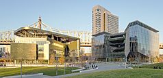
The southern end of the island also has four buildings for the Cornell Tech university campus. This huge campus has 2 million square feet of space on 11 acres. The first part of the campus includes a main academic building, a student housing tower, and an innovation hub. The 26-story Cornell Tech residential tower has 350 apartments. It was designed to be a very energy-efficient building. Cornell Tech's first phase also has a conference center and a hotel. The hotel, called the Graduate Roosevelt Island, opened in 2021. It is the island's first hotel.
Famous Landmarks

Roosevelt Island has six buildings and structures that are New York City designated landmarks. All of them are also listed on the National Register of Historic Places.
- The Blackwell House on Main Street is one of the city's few remaining farmhouses. It was built between 1796 and 1804.
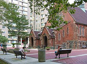
- The Chapel of the Good Shepherd is an Episcopal church from 1889.
- The Roosevelt Island Lighthouse is an octagonal Gothic-style lighthouse. It is at the northern end of the island and was built in 1872. It is 50 feet (15 m) tall.
The other three landmarks are former hospitals:
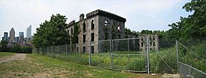
- The Smallpox Hospital at the island's southern tip is a Gothic-style ruin. It was built in 1857 as the first smallpox hospital in the U.S.
- The Strecker Laboratory is a Romanesque Revival-style electrical building. It was built in 1892 as a laboratory.
- The Octagon is the only part left of the 1839 Lunatic Asylum.
The ruins of the City Hospital, a building from the mid-1800s, were torn down in 1994 because they were in very bad shape.
Island Governance and Services
Roosevelt Island is part of Manhattan Community Board 8. Even though it is in Manhattan, its emergency services often come from Queens. Other services, like its ZIP Code and area code, are from Manhattan. The island's ZIP Code is 10044.
The Roosevelt Island Operating Corporation (RIOC) is a state organization that manages the island. RIOC handles transportation and security. It also leases out stores, helps develop apartments, and protects the island's landmark buildings. RIOC's money comes from fees paid by private developers.
Utilities
Parts of New York City Water Tunnel No. 3, which brings fresh water to New York City, pass under the island. This section opened in 1998. Roosevelt Island also had its own steam plant until 2013.
Verdant Power has installed tidal turbines under the East River. These turbines use the river's currents to create energy. They power small parts of the island.
Waste Disposal
Before the 1970s, raw waste from Roosevelt Island went directly into the East River. Now, garbage on Roosevelt Island is collected by a special system. It uses pneumatic tubes, which are like giant vacuum tubes. This system was installed in 1975. It was one of the first of its kind in the U.S.
It is one of the world's largest tube systems for garbage. It collects trash from 16 apartment buildings. Trash travels through the tubes at up to 60 miles per hour (97 km/h). The garbage then goes to a central plant where it is crushed and sent to a landfill.
Emergency Services
NYC Health + Hospitals/Coler is the only public hospital on Roosevelt Island since 2013. The island gets its emergency services from Queens. The New York City Police Department's 114th Precinct patrols the island. The Roosevelt Island Public Safety Department also patrols the island. Its officers can make arrests but do not carry weapons.
Roosevelt Island does not have its own fire station. Fire services come from Engine Company 260 in Astoria, Queens. The FDNY also has a special training facility on the island.
Parks and Recreation
When Roosevelt Island was redeveloped, about a quarter of its land was set aside for parks. The island has four main parks: Lighthouse, Octagon, Southpoint, and Four Freedoms parks.
- Lighthouse Park is at the northern tip of the island. It is named after the Blackwell Island Light.
- Octagon Park is a 15-acre (6.1 ha) green space. It has a stage facing the East River.
- Southpoint Park is a 7-acre (2.8 ha) green space near the south end. It contains the old Strecker Lab and Smallpox Hospital buildings.
- The 4-acre (1.6 ha) Franklin D. Roosevelt Four Freedoms Park opened in 2012 at the island's southern end. It was designed by Louis Kahn. It has two rows of trees leading to a granite "room".
There is also a smaller park around the Blackwell House. The entire island has a path along the waterfront that is open to the public. Roosevelt Island has received awards for its many trees.
Recreational Facilities
Roosevelt Island has four outdoor sports fields:
- Capobianco Field
- Firefighters Field, near the ferry terminal
- McManus Field, at the north end of the island. It has soccer, tennis, and baseball areas. It was renamed in 2019 to honor Jack McManus, a former safety chief.
- Pony Field, east of the Octagon
The Roosevelt Island Racquet Club has 11 tennis courts under domes. The Sportspark is an indoor recreation center. It has a studio, swimming pool, gym, and recreation room. There are also more tennis courts in Octagon Park.
Island Education
Schools and Higher Education
The New York City Department of Education serves Roosevelt Island. When the island was redeveloped in the 1970s, there were plans for many schools. The schools taught fine arts and foreign languages.
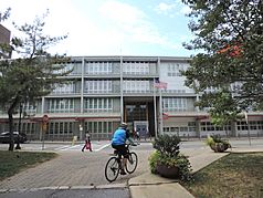
The first school on Roosevelt Island opened in 1975. By the 1980s, the island had five school buildings. In 1992, all the island's schools combined into PS/IS 217 Roosevelt Island School on Main Street. This is the only public school on the island, serving students from pre-kindergarten to 8th grade. High school students usually go to schools in Manhattan. The Child School and Legacy High School helps children with special learning needs.
In 2011, Mayor Michael Bloomberg announced that Cornell Tech would be built on the island. This is a graduate school for applied sciences from Cornell University and Technion-Israel Institute of Technology. The first part of Cornell Tech opened in 2017.
Library
The New York Public Library (NYPL) has a branch on Roosevelt Island at 504 Main Street. The library started in the 1970s as a volunteer effort. Two residents, Dorothy and Herman Reade, opened the first library in 1976.
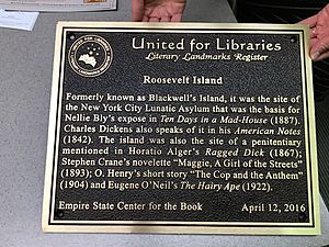
The library became a branch of the NYPL system in 1998. This gave it access to the NYPL's much larger collection. A plaque was placed on the island in 2016, noting its connections to literature. The current NYPL branch opened in January 2021.
Religion
Roosevelt Island has had churches and chapels for different Christian groups. The Chapel of the Good Shepherd was the island's first church. It operated until 1958 and reopened as a community center in 1975. Other chapels for Catholic and Lutheran communities were built but have since been torn down.
The Council Synagogue opened on Welfare Island in 1926. After the island was redeveloped, the Roosevelt Island Jewish Congregation was founded. The Chabad Lubavitch Center of Roosevelt Island moved into their space in 2006. There is also a mosque run by the Islamic Society of Roosevelt Island.
Island Transportation
For a long time, Roosevelt Island was hard to get to. Only rowboats could reach it until the early 1900s. Even in the 1950s, the only ways to get there were a ferry from Manhattan or an elevator from the Queensboro Bridge.
Today, you can reach the island by bridge, aerial tramway, ferry, and subway. The tramway and subway stations are accessible for wheelchairs. However, sometimes these services have problems, making it hard for people with disabilities to travel.
Walking and Driving
Roosevelt Island is directly under the Queensboro Bridge, but you cannot get to it directly from the bridge anymore. A trolley used to connect passengers from Queens and Manhattan to a stop on the bridge. From there, people took an elevator down to the island. The trolley ran until 1957. The elevator building was torn down in 1970.
The Roosevelt Island Bridge opened in 1955. It crosses the East River to Astoria, Queens. This is the only way for cars to get to the island. It also has a sidewalk for walkers. There is a bike lane on the bridge.
The main parking garage on Roosevelt Island is the Motorgate Garage. It has a concrete design. It also included the island's first post office and fire station. There are also parking meters on Main Street, but parking is limited. Since 2020, the island has Citi Bike stations for bike sharing.
Public Transportation
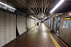
The New York City Subway's 63rd Street Line was planned in 1965 to have a station on the island. Subway service began in October 1989. The Roosevelt Island station is one of the deepest subway stations. It is more than 100 feet (30 m) below ground. Other subway lines also pass under Roosevelt Island without stopping.
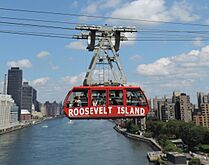
The Roosevelt Island Tramway was built in the 1970s because the subway was delayed. It opened in May 1976. It connects the island to Midtown Manhattan. The tram was rebuilt in 2010.
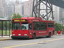
The MTA Bus's Q102 route runs between the island and Queens. It makes a loop around Roosevelt Island. RIOC also runs the Red Bus, a free shuttle bus service. It goes around the island, connecting apartment buildings to the subway and tramway.
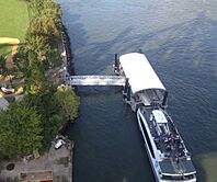
A ferry service used to run from Welfare Island to Manhattan from 1935 to 1956. Roosevelt Island has been served by NYC Ferry's Astoria route since August 2017. The ferry dock is on the east side of the island.
Notable People
Famous Visitors
- Charles Dickens – a famous writer who visited the asylum on the island in 1842.
- Nellie Bly – a journalist who pretended to be a patient in the Women's Lunatic Asylum in 1887. She wrote a famous report about the conditions there called Ten Days in a Mad-House.
Famous Residents
- Kofi Annan (1938–2018) – former United Nations Secretary-General.
- Michelle Bachelet (born 1951) – former president of Chile.
- Jonah Bobo (born 1997) – actor.
- Perry Chen (born 1976) – creator of Kickstarter.
- Alice Childress (1912–1994) – playwright and author.
- Billy Crawford (born 1982) – singer and actor.
- Mike Epps (born 1970) – comedian and actor.
- Al Lewis (1923–2006) – actor, known as "Grandpa" in The Munsters.
- Sarah Jessica Parker (born 1965) – actress.
See also
 In Spanish: Isla Roosevelt (Nueva York) para niños


