
Rottenschwil facts for kids
Quick facts for kids
Rottenschwil
|
||
|---|---|---|
 |
||
|
||

Rottenschwil
Location in Switzerland

Rottenschwil
Location in Canton of Aargau
|
||
| Country | Switzerland | |
| Canton | Aargau | |
| District | Muri | |
| Area | ||
| • Total | 4.49 km2 (1.73 sq mi) | |
| Elevation | 387 m (1,270 ft) | |
| Population
(Dec 2020 )
|
||
| • Total | 911 | |
| • Density | 202.9/km2 (525.5/sq mi) | |
| Postal code |
8919
|
|
| Surrounded by | Aristau, Besenbüren, Hermetschwil-Staffeln, Jonen, Oberlunkhofen, Unterlunkhofen | |

Rottenschwil is a small town, also called a municipality, in the Muri area of the canton of Aargau in Switzerland. It is a quiet place with a rich history.
Contents
History of Rottenschwil
The first signs of people living in the Rottenschwil area date back to the Roman times. There was a Roman farm here long ago. The name Rotolfswile was first used for the modern town in 1281.
A powerful group called Hermetschwil Abbey owned most of the land. However, the Habsburgs controlled the "vogtei" office. This meant they had power over the Abbey's land. In 1415, the Swiss Confederation took over these rights.
From 1415 to 1798, Rottenschwil was part of the Muri area. This region was known as the Freie Ämter. It was ruled by some or all of the Swiss Confederates.
A ferry across the Reuss river was first mentioned in 1312. In 1510, Muri Abbey sold its share of the ferry's profits. They sold it to the city of Bremgarten. Floods often caused problems for the people and buildings. In 1580, Hermetschwil Abbey helped build a milldam on the river. This helped control the water.
During the Helvetic Republic (1798–1803), Rottenschwil was part of the Bremgarten district. This was in the Canton of Baden. After 1803, it became part of the Muri District. This was in the new Canton of Aargau.
In 1860, a canal was built between Mühlau and Hermetschwil. This created more farmland for the town. A bridge over the Reuss river was built in 1905-06. This made travel much easier. In 1969, a project called the Reuss Valley Amelioration helped the land. It made more land useful and reduced flood damage. A large nature area of about 60 hectares was created in 1972. This area helps protect local plants and animals.
Geography of Rottenschwil
Rottenschwil covers an area of about 4.49 square kilometers (1.73 square miles). A big part of this land, about 55.2%, is used for farming. Forests cover about 23.8% of the area. Buildings and roads take up about 7.3% of the land. Rivers and lakes make up about 5.3%. The remaining 7.6% is land that cannot be used for farming or building.
Most of the built-up area is for homes and other buildings (3.6%). Roads and other transport areas make up 2.9%. In the forested areas, 22.7% is dense forest. Small groups of trees or orchards cover 1.1%. For farming land, 41.4% is used for growing crops. Pastures for animals make up 12.5%. A small part, 1.3%, is used for orchards or grapevines.
About 2.4% of the water in the town is in lakes. Rivers and streams make up 2.9%. The unproductive areas are mostly covered with plants that are not farmed.
The town is in the Muri district. It sits on the left bank of the Reuss river. Rottenschwil includes the main village and two smaller settlements. These smaller settlements are called hamlets: Stägen and Werd.
Coat of Arms
The blazon (official description) of Rottenschwil's coat of arms is: "Blue, a Pike fish, with a gold star above and three wavy silver lines below." This means the shield is blue. It shows a fish called a pike. Above the fish is a gold star. Below the fish are three wavy silver lines. These lines likely represent the river.
People of Rottenschwil (Demographics)
Rottenschwil has a population of about 807 people. As of June 2009, about 10.5% of the people living here were from other countries. Over ten years (1997–2007), the population grew by about 3%. Most people in Rottenschwil (94.3%) speak German. Portuguese is the second most common language (1.2%), followed by French (1.0%).
Looking at the age of people in 2008:
- 13.1% are children aged 0 to 9 years old.
- 16.6% are teenagers aged 10 to 19.
- 9.4% are young adults aged 20 to 29.
- 12.8% are aged 30 to 39.
- 19.3% are aged 40 to 49.
- 16.4% are aged 50 to 59.
- 7.6% are aged 60 to 69.
- 2.9% are aged 70 to 79.
- 1.6% are aged 80 to 89.
- 0.2% are 90 years old or older.
In 2000, there were 304 homes in Rottenschwil. On average, there were 2.6 people living in each home. In 2008, 145 homes were single-family houses. This was about 46.6% of all homes. Only 1 apartment was empty, meaning almost all homes were occupied. In 2007, new homes were being built at a rate of 2.4 new homes for every 1000 residents.
In the 2007 Swiss federal election, the most popular political party was the SVP. They received 38.4% of the votes. Other popular parties were the CVP (21%), the SP (17.3%), and the FDP (8.4%).
Economy of Rottenschwil
In 2007, Rottenschwil had a low unemployment rate of 1.19%. This means most people who wanted jobs had them.
In 2005, there were 29 people working in the primary economic sector. This sector includes jobs like farming and fishing. There were 11 businesses in this area. The secondary sector had 75 workers and 13 businesses. This sector includes jobs like manufacturing and construction. The tertiary sector had 64 workers and 23 businesses. This sector includes jobs like services, shops, and offices.
In 2000, 429 people who lived in Rottenschwil had jobs. Most of them (77.6%) worked outside the town. However, 76 people came into Rottenschwil to work. There were 172 jobs available in the town. For getting to work, 15.5% of people used public transport. A larger number, 57.6%, used a private car.
Religion in Rottenschwil
Based on the 2000 census, 469 people (58.2%) were Roman Catholic. Another 219 people (27.2%) belonged to the Swiss Reformed Church. There was also 1 person who belonged to the Christian Catholic faith.
Education in Rottenschwil
In Rottenschwil, about 83% of adults (aged 25-64) have finished either non-mandatory upper secondary education or higher education. Higher education means they went to a university or a Fachhochschule (a type of professional university). In the 2008/2009 school year, 100 students attended primary school in the town.
Images for kids
-
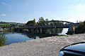
Reuss Bridge near Rottenschwil
-
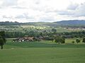
The hamlet of Werd


See also
 In Spanish: Rottenschwil para niños
